Little-known facts about cyclones
This is a continuation of our series about cyclones in temperate latitudes—so familiar, yet so unusual. In this article, we will share some unexpected and useful tips about what the weather is like inside cyclones, and what to pay special attention to when you look at a forecast.
Drizzle and fog
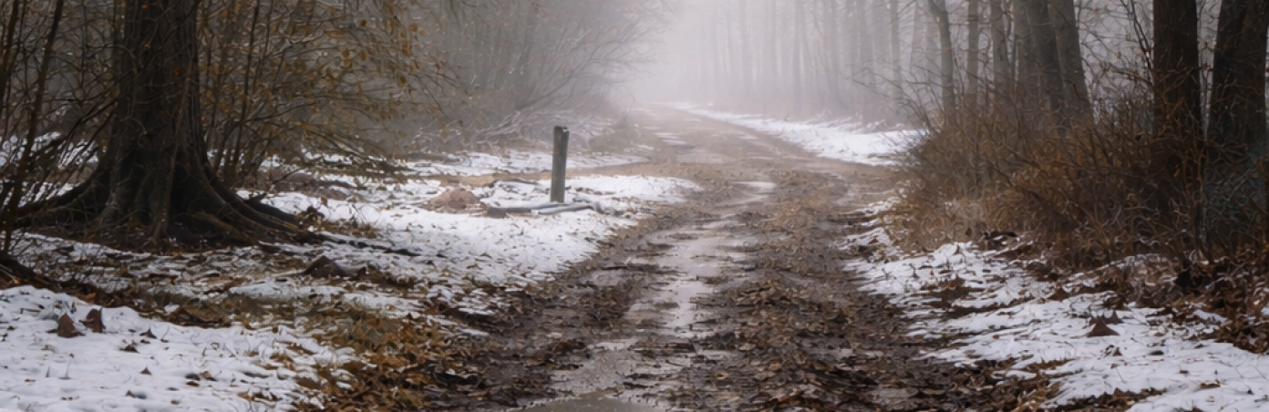
What do you imagine when you hear that you are in a warm sector? Perhaps lying on a beach under gentle sun rays? Unfortunately, that is not quite the way it works.
The warm sector of a cyclone is the area between the warm and cold fronts—when the warm front has already passed, and the cold front is still approaching. It is indeed warmer here than in most other parts of the cyclone, but the sun is rarely visible, the humidity is high, and drizzle or fog occurs from time to time.
The wind can also be quite strong. By the way, for outdoor enthusiasts who need strong but predictable winds, the warm sector often offers a good window of opportunity.
Squalls and showers
A cyclone has another sector: the cold sector. It begins right after the cold front passes, and it can rightly be called a realm of chaos. It is the zone where rain falls «here and there,» and near-calm conditions alternate with dangerous gusts. And this is exactly the kind of weather when it is hard to decide whether or not to take an umbrella with you.
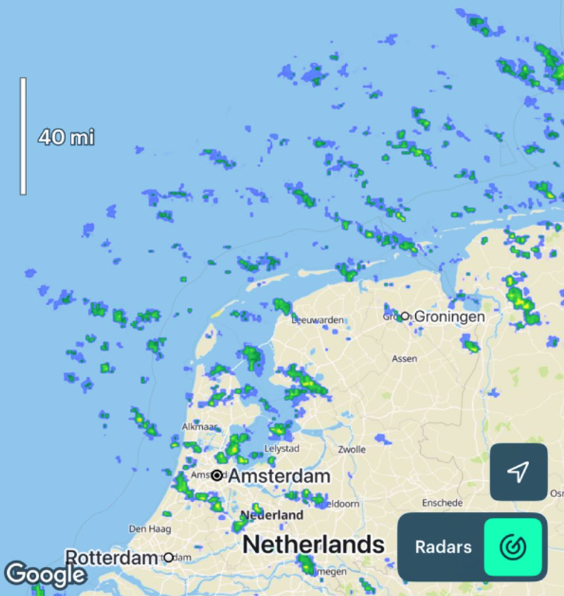
If you see something like this on the radar, you are most likely in the cold sector, and it is better to take an umbrella.
Being in the cold sector means that all of the main fronts are already behind you, and the sun has finally come out. Is it time to go outside? On the one hand, yes; but it is precisely in the cold sector that gusty winds are often much stronger than forecast. In addition, do not forget about secondary fronts. These are weaker «followers» of the main cold front, and they will certainly not allow you to escape wind and showers fully.
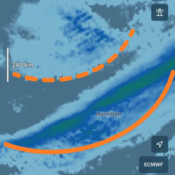
On this precipitation map, the cold front is shown as a solid line, and the secondary front is shown as a dotted line.
Therefore, in the cold sector, it is especially important to check the weather using all of the available data and, if possible, prepare for a worst-case scenario.
The centre of the storm
Many people are familiar with the "eye of the storm"—the area in the centre of a tropical cyclone with almost completely calm weather. It provides a brief break between heavy rain and violent winds, and it looks truly spectacular.

The eye of the hurricane. Source: Pierre Markuse. Contains modified Copernicus Sentinel data 2023.
Cyclones in temperate latitudes do not have an eye, although the steady wind near the centre is usually weak. However, even if the forecast promises zero wind, gusts can still be strong due to overall atmospheric instability. This is especially important for those going out on open water: in difficult conditions, we recommend paying at least as much attention to gusts as to the mean wind speed.
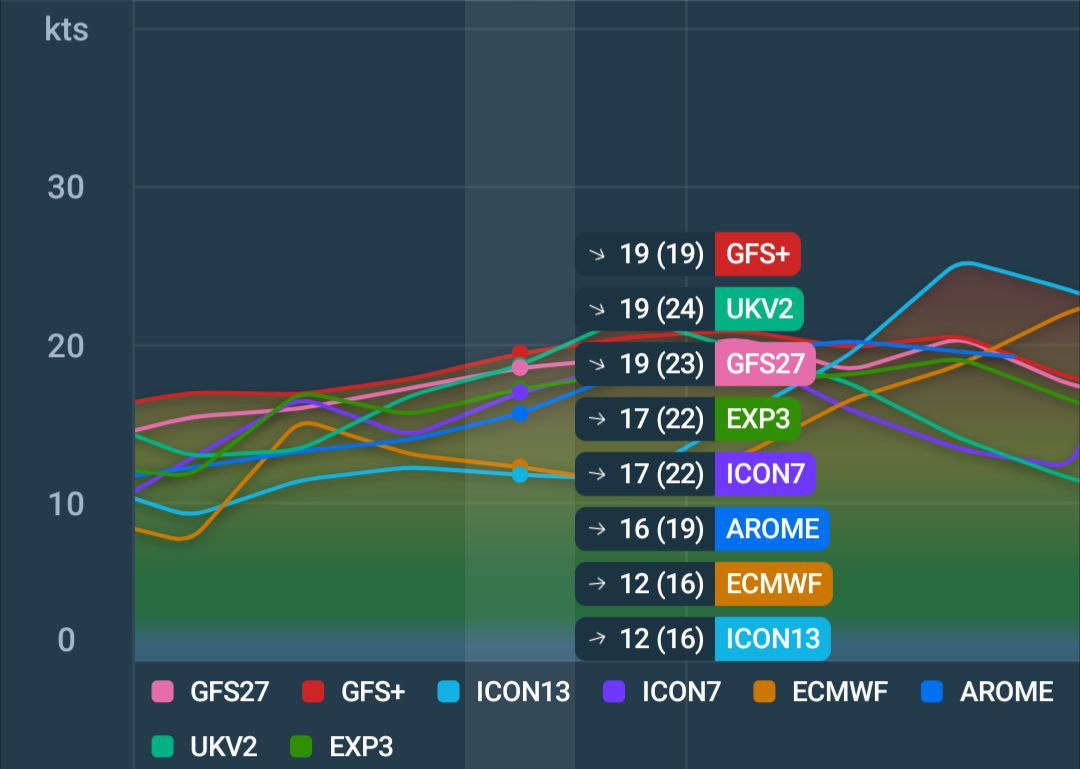
The centre of the cyclone in model comparison mode. Gusts are shown in brackets on the graph. Wind speeds from 12 to 24 knots can be a critical factor on the water.
Rain and thunderstorms in the centre of a cyclone do not disappear either; on the contrary, they can be among the strongest. Therefore, steering a vessel into the centre of a cyclone in the hope of waiting out the storm is not a good idea.
Fronts can become invisible
Did you dream of becoming invisible as a child? I still do! But fronts do not dream—they act. Only this does not happen at will, but depends on the time of day.
A cold front gets much of its strength from daytime heating of the ground. At night, when the surface cools and convection weakens, a cold front can almost completely «disappear.» Clouds and precipitation may vanish. Only a change in wind direction (the main sign of a front) and a temperature drop remain. During the day, when the ground warms again, the cold front can return as if nothing had happened.
A warm front, on the other hand, often becomes more active at night. If it brings mainly drizzle during the day, thunderstorms and gusty winds may appear after dark. Only the occluded front is deprived of this superpower: heavy precipitation can occur around the clock.
The better we understand cyclones, the easier it is to anticipate what to expect from them. That is why we strongly recommend using the «Fronts and Isobars» layer in Windy. app.
At the same time, most of what we know about cyclones is already built into modern weather models, and even professional meteorologists rely on them as a first indicator. Convenient tools, such as model comparison mode, allow you to quickly estimate how much forecasts differ. And if you combine this with an understanding of the «character» of the current weather, you will notice that you make the right decisions much more often.
Text: Eugenio Monti, a meteorologist and a climatologist
Read more:
Latest News
Professional Weather App
Get a detailed online 10 day weather forecast, live worldwide wind map and local weather reports from the most accurate weather models.
Compare spot conditions, ask locals in the app chat, discover meteo lessons, and share your experience in our Windy.app Community.
Be sure with Windy.app.


