
Why Do People See Dementors in the Sky?
Most clouds look harmless. But not all of them. Sometimes, you spot clouds that make you want to find shelter—and in some cases, that’s exactly what you should do.
Who’s Tearing the Clouds Apart?
All clouds form from water that evaporates, from the ground and bodies of water. This water rises into the sky as vapor, condenses when it collides with tiny airborne particles, and turns back into microscopic water droplets.
In areas of intense evaporation, condensation also happens rapidly. The droplets grow, and when enough water has accumulated, the cloud darkens—turning into a heavy cumulonimbus cloud, which eventually releases its moisture as rain or storms.
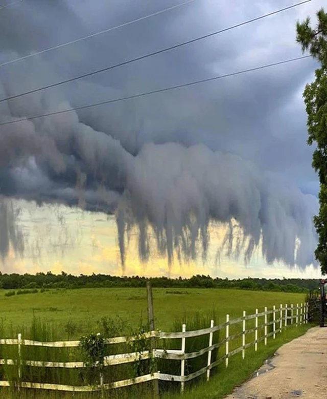
Scud clouds over South Carolina. Photo: Zachary Lane
Where there are thunderstorms and rain, there’s turbulence—not just high up where airplanes fly, but also closer to the ground. Cold downdrafts from rain collide with warm updrafts from surface evaporation, creating swirling air currents. The difference in temperature and pressure generates powerful winds, causing the air to shift direction constantly.
When a thunderstorm cloud encounters strong upward currents—such as when a cold front forces warm surface air to rise—condensation can intensify right beneath the cloud.
But in turbulent conditions like these, fully formed clouds don’t always develop. Instead, fragmented wisps of irregular shapes appear, as if someone scattered pieces of cotton candy across the sky. But not the fluffy pink or white kind—these are ominous, dark gray formations. (Does this flavor exist?)
These eerie, shredded-looking quasi-clouds, stretching toward the ground like the tendrils of some malevolent deity, are called scud clouds. And if you see them, it’s usually a sign that bad weather is nearby.
Not a Tornado, But Still a Warning
Scud clouds themselves aren’t dangerous. However, their dramatic appearance and rapid motion—twisting, breaking apart, and sometimes even moving faster than the thunderclouds above—often cause them to be mistaken for funnel clouds, the precursors of tornadoes. The key difference? Scud clouds do not rotate. That’s the easiest way to tell them apart from other storm-related formations.
Another distinguishing feature is that scud clouds are not attached to a parent cloud, unlike funnel clouds. They always move independently, constantly shifting shape until they dissolve into the air. They don’t last long—usually only a few minutes to an hour—so spotting and photographing them is a rare occurrence.
While scud clouds aren’t a direct threat, their presence signals nearby severe weather—often an approaching thunderstorm with heavy rain, strong winds, and turbulence. Experienced drivers and boaters recognize them as a warning sign, and meteorologists take them into account when forecasting storms.
If you’re eager to witness scud clouds in person (and plan to do so cautiously), look for them in areas prone to strong thunderstorms, high winds, and high humidity near the surface. Tornado-prone regions—such as the central and eastern United States—are prime locations.
Scud clouds are often spotted at the edge of weather fronts, beneath shelf or roll clouds—cumulonimbus formations shaped into a tube by intense turbulence.
If you ever capture scud clouds in a photo or video, you might impress your friends by saying you saw Dementors! These eerie, ragged formations are often compared to the ghostly creatures from the Harry Potter universe. Your millennial friends might even believe you.
Text: Jason Bright, a journalist and a traveller.
Cover photo: Jocelyn Hunter
Read more:
Latest News
Professional Weather App
Get a detailed online 10 day weather forecast, live worldwide wind map and local weather reports from the most accurate weather models.
Compare spot conditions, ask locals in the app chat, discover meteo lessons, and share your experience in our Windy.app Community.
Be sure with Windy.app.


