How to read wind rose. Look, it is not only beautiful, but useful to you
The wind rose is a diagram of the wind, or a picture of wind changes. It is indispensable to use for water sports that require strong wind or waves: kite-, wind- and regular surfing, sailing, paragliding. It’s also necessary for activities wind may ruin: fishing, cycling, and others. Let's learn more about what is wind rose and how to read it.
What is a wind rose?
The wind rose is a vector diagram or a graphical chart, presented in a circular format, that illustrates wind direction and speed, measured at weather stations. To be more particular, it shows the possibility of every direction of the wind and its strength.
Wind roses are also taken into account in the construction of runways of airports, highways, the layout of settlements (orientation of buildings and streets), and many other economic tasks in agronomy, forestry, parks, ecology, and others.
The wind rose, built on the basis of real observation data, allows to reveal the direction of the prevailing wind in a particular area by the length of the rays.
Wind roses are often used instead of wind tables to make information more vivid.
What are the types of wind roses and how to read a roses of wind?
The traditional wind rose is a circle with colored bars sticking out its center. It could be 8, 16, or 360 bars in it. It looks very similar to the compass with cardinal directions:
.jpg)
Wind rose. Illustration: Valerya Milovanova / Windy.app
On the wind rose diagram you see wind cardinal direction and wind speed (m/s, mph and so on).
The length of each bar shows the frequency of this direction. For example, if you see only one bar on the plot, just one direction of the wind is possible. If you see several bars, all of those directions will occur, and the longest bar will mean the most frequent direction. You also see the percentage (%) of time during which the wind blows in one direction or another.
There can be several colors for one bar. The colors means wind speed. In this case, the longest color is the most frequent.
Where to find and how to interpret a wind rose in Windy.app?
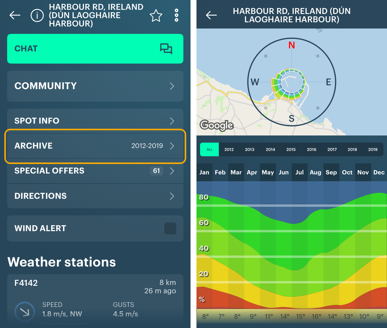
The wind rose you see in Windy.app is a traditional wind rose, like on the picture above, but in the app, it could be in two places: on the spot and in the Weather Archive. Let's deal with what we see on the wind rose in both cases. Reading a wind rose in the Windy.app is easy:
The wind rose on the spot
Open the spot and choose the date you want to get the forecast for: today, tomorrow or any day in the next 10 days. If you want, change the forecast step: 1 hour or 3 hours. So if you click on the forecast for a definite hour, on the wind rose you will see only wind speed and direction for this moment.
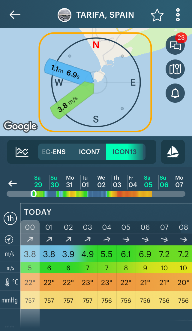
Now you are ready to read a wind rose. It looks a bit different here:

Direction. The green bar indicates the wind blowing FROM the definite cardinal direction, the direction is signed on the plot. In this case, from the southwest (SW) to the northeast (NE).
Speed. The same green bar shows the speed of wind blowing from its direction for the chosen day and forecast step (1 h or 3 h).
The speed measured in units, depending on the part of the world you live: meters per second (m/s), miles per hour (mph), kilometers per hour (kph), knots (knt: 0.514 m/s, 1.15078 mph, 1.852 kph, 1 nautical mile per hour), beaufort (Beaufort wind force scale).
The color of each bar also shows the speed, so it could be not only this type of green, but other colors. The color varies from dark blue for the lowest wind speed to purple for the strongest wind.
You can get this table of colors at the end of weather parameters list. Tap on weather profile icon right to the weather models, for example, kitesurfing.
The wind rose in the Windy.app is unusual. In addition to wind data you also see the data of waves, what is important to do different kinds of water sports and outdoor activities like surfing, kitesurfing, and kiteboarding, and windsurfing: swell size, direction, and period.
- Swell is a series of waves.
- Swell size (on the screen: 1.1 meters) is an average height of 1/3 of the highest waves in the swell. For an amateur surfer, the size of the good waves is from 1 meter, m (3.5 feet, ft) to 3 m (10 ft).
- Swell direction is the cardinal direction FROM which the swell is coming. For example, from the northeast (NE) to the southwest (NW). The more directed the swell is when hitting the beach, the stronger the waves.
- Swell period (on the screen: 6.9 seconds) is the time between successive waves, or swell frequency. The longer the period, the faster and more powerful the waves. 8 seconds (s) — normal surfing, 11 s — good, 14+ s — great (pure ground swell).
Now move the slider to see wind roses for more distant forecasts. If you click on the forecast for a definite hour, on the wind rose you will see only illustrated wind speed and direction for this moment. The same goes for wave characteristics.
The wind rose in Weather History
Weather history is statistical data on the state of the atmosphere and the ocean, collected on the basis of regular meteorological observations.
In Windy.app weather history is the weather that occurred on a spot in the past. This data is taken from the forecast for the spot and is available since 2012 — for the last 8 years. The feature is called Weather Archive. Learn more about the weather history feature.
Here you see the same wind rose with wind direction and wind speed (units and colors):

To see the wind speed colors data, slide from the left to the right of the screen:
Read guide to the app. Follow us in a Facebook, Instagram, Twitter, LinkedIn, YouTube. Subscribe to our newsletter to get Windy.app Meteorological Textbook (WMT) with 50+ lessons on better weather forecasting and receive a new lessons right to your email once a week. Write your own post in the blog. Cooperate with the team, if you are a business or content creator.
Read more meteo lessons in Windy.app Textbook.
Text: Evgeniy Petrov and Ivan Kuznetsov
Illustration: Valerya Milovanova, an illustrator with a degree from the British Higher School of Art an Design (BHSAD) of Universal University
Cover photo: marcreation / unsplash
You will also find useful
How to read Wind Chill Chart to stay comfortable outdoors
What are wind alerts and how to use them for your sport or outdoor activity
Latest News
Professional Weather App
Get a detailed online 10 day weather forecast, live worldwide wind map and local weather reports from the most accurate weather models.
Compare spot conditions, ask locals in the app chat, discover meteo lessons, and share your experience in our Windy.app Community.
Be sure with Windy.app.


