Hurricane Sally 2020 No More Dangerous and Left the US
The new hurricane Sally 2020 was category 2 tropical cyclone, which was active in the south of the United States.
Warning: if you live in the area affected by hurricane Sally 2020, follow all precautions recommended by local police, fire department, medical services, and other official government organizations to minimize the impact of typhoon. Contact the appropriate services if you experience difficulties.
Bookmart this page to get hurricane Sally 2020 updates, tracker and live map, forecast, latest news, quick facts, and detailed information from this page.
Update: September 20, 2020, Tuesday, 06:00 a.m. UTC. Hurricane Sally 2020 No More Dangerous and Left the US.
Hurricane Sally 2020 No More Dangerous and Left the US on Sep. 20, 2020.
Update: September 16, 2020, Tuesday, 06:00 a.m. UTC. Hurricane Sally 2020 Influences the Gulf of Mexico Coast As Landfall Is Expected in Several Hours
After a short period of weakening into Category 1 in SSHWS, hurricane Sally 2020 now strengthened back into Category 2. Wind speed near the center is now 90 kt (170 km/h or 105 mph).
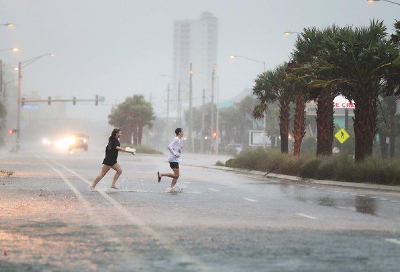
Hurricane Sally 2020 is now 50 miles (80 km) away from Mobile, Alabama. The city is expected to be mostly damaged by hurricane winds. Sally is now slowly moving to the north, towards the city. This track makes New Orleans safe from catastrophic winds and rains but it already suffers from storm surges. You can see the flooding on the video.
Meanwhile the influence of strong winds is already felt in southern Mississippi, Alabama and western Florida. Just as in New Orleans, the influence is now mostly felt as storm surges.
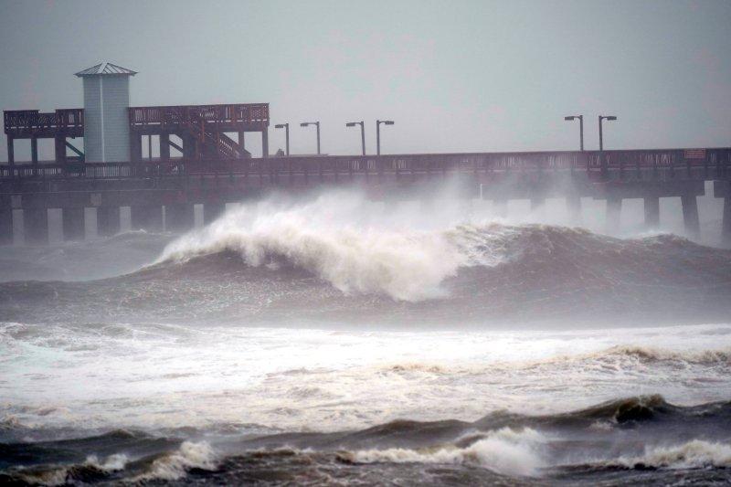

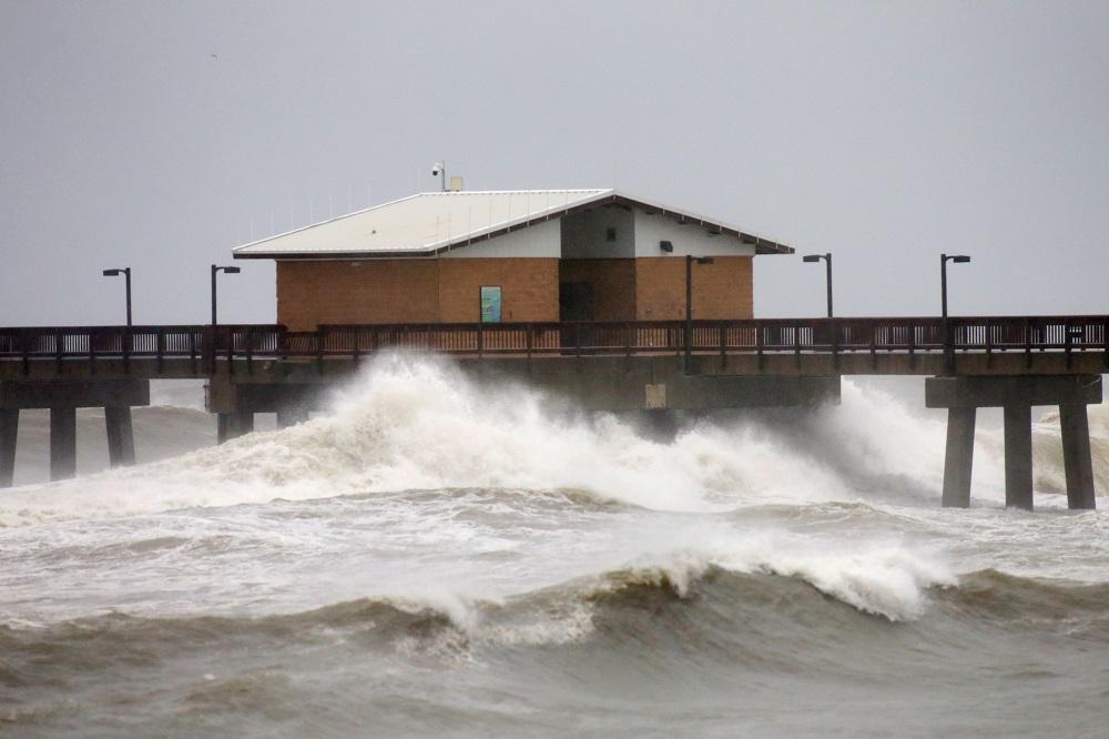
The damage is minor but the main action is still ahead. Surges up to 7 inches (2 meters) and record-beating rainfall of 30 inches (760 mm) are also expected in some spots.
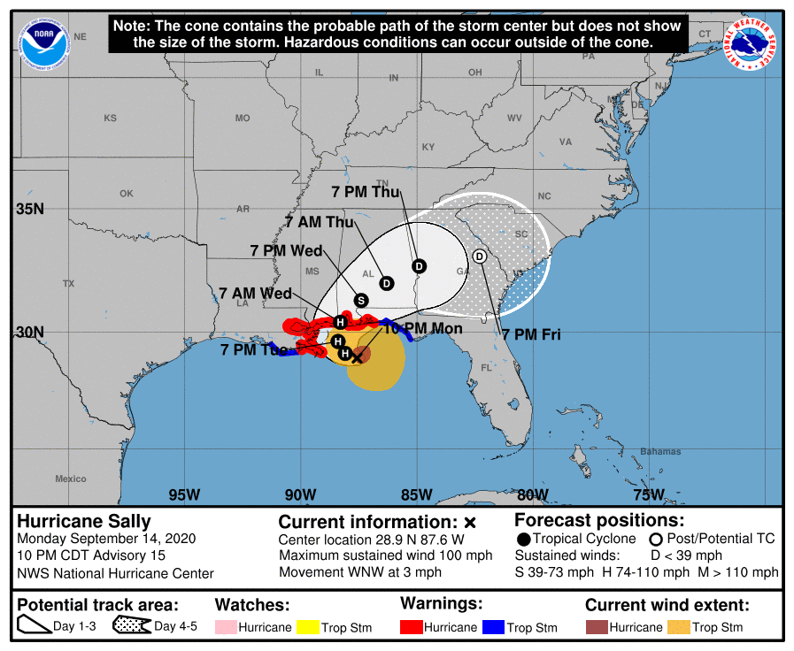
The landfall is expected in approximately 6 hours and will happen on Wednesday, September 16, 12-18 UTC. The closest and the most endangered cities are Mobile and Pensacola. Strong winds and great floodings are expected on the coast and on the continent. The next cities to be affected are Montgomery, Columbus and Dothan.

According to the forecasts, after the landfall the hurricane will turn east and weaken into tropical depression. The winds will become much slower but heavy rains and thunderstorms will exist in this low pressure system for several days.
It will influence Georgia, northern Florida, South Carolina and North Carolina with the cities of Macon, Warner Robins, Albany, Savannah, Wilmington and others.
Update: September 15, 2020, Tuesday, 06:00 a.m. UTC. New Category 2 Hurricane Sally 2020 Threatens Southern US States. The Landfall Is Expected on Wednesday, September 16
Hurricane Sally is less than 170 miles (270 km) away from New Orleans and less than 100 miles (150 km) from the coastline. Wind speed near the center is now 85 kt (155 km/h or 100 mph). It makes it a Category 2 hurricane in SSHWS.
Sally is now moving towards New Orleans. The impact on the continent is still pretty slight. The landfall is expected on Wednesday, September 16. The most endangered are eastern Louisiana, southern Mississippi and Alabama. Strong winds and heavy rains will affect large continental areas. High waves are possible at the coastline. Floods are highly possible.
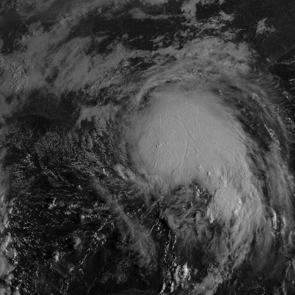
Satelite image of the hurrcane Sally 2020
After the landfall the hurricane will turn east and weaken into tropical depression. The winds will become much slower but heavy rains and thunderstorms will exist in this low pressure system for several days. It will influence Georgia, northern Florida and probably all the states of the Eastern Coast.
Hurricane Sally was formed on September 11 to the east from Florida. It was forecasted to be weak and not to get a category in SSHWS. Sally passed South Florida as a tropical storm or even tropical depression on Saturday, September 12. It had a wind speed of only 30 kt (55 km/h or 35 mph) but still left many households without power.
Projected path of the hurrcane Sally 2020
After entering Carribean Sea with its warm water the depression started to intensify. Soon it got hurricane wind speed and became real danger to Southern US states.
Quick Summary Updated Facts About Hurricane Sally 2020
- Name: hurricane Sally 2020.
- Other names: tropical storm Sally 2020, subtropical depression Sally 2020, tropical cyclone Sally 2020, named storm Sally 2020, and others.
- Start date: September 11, 2020.
- Number in the Pacific Typhoon Season 2020: 18th (eighteenth named storm).
- Type: hurrane.
- Category: 2 in a SSHS (Saffir-Simpson Hurricane Wind Scale).
- Speed: 90 knots (170 km/h or 105 mph) in 1 minute mean.
- Gusts: 105 knots (195 km/h or 120 mph).
- Central pressure: 986 mb.
- Place of activity: Gulf of Mexico, Carribean Sea, Atlantic ocean.
- Cities, regions and countries affected: Louisiana (New Orleans), Mississippi, Alabama (Mobile), Florida (Pensacola).
- Damage: no data.
- Possible end date: September 17, 2020.
- Total possible activity: 6 days.
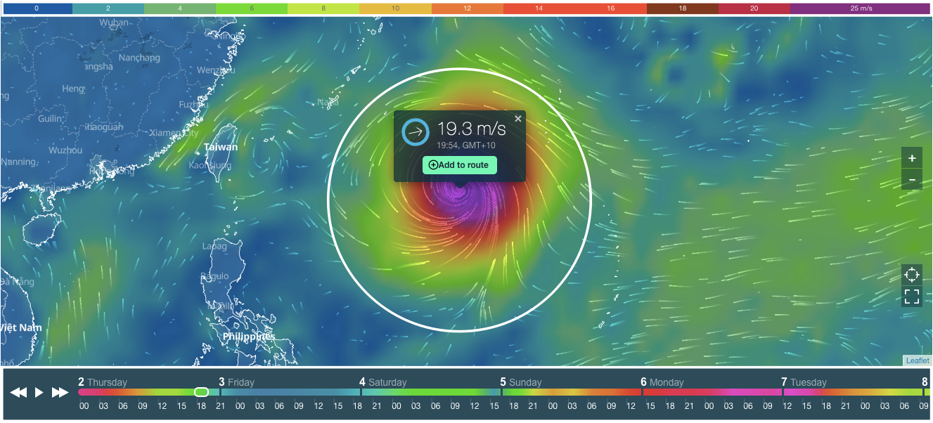
Hurricane Sally 2020 Tracker and Live Map
On the cover of this page, you see tracker and live map of the hurricane Sally 2020.
Scroll or zoom (+ / -) the cover to find out where the hurricane is now, and how strong it is. You can also determine the speed of the hurricane by its color. On top of the live map, there is a colorful scale. The speed is in m/s (meters per second).
At the bottom of the map, there is a weather forecast for the next 10 days. Scroll it to the right to see the projected path (track) of the hurricane Sally 2020. Or push the arrows or the "Play" button to get the forecast.
Weather Forecast for Hurricane Sally 2020
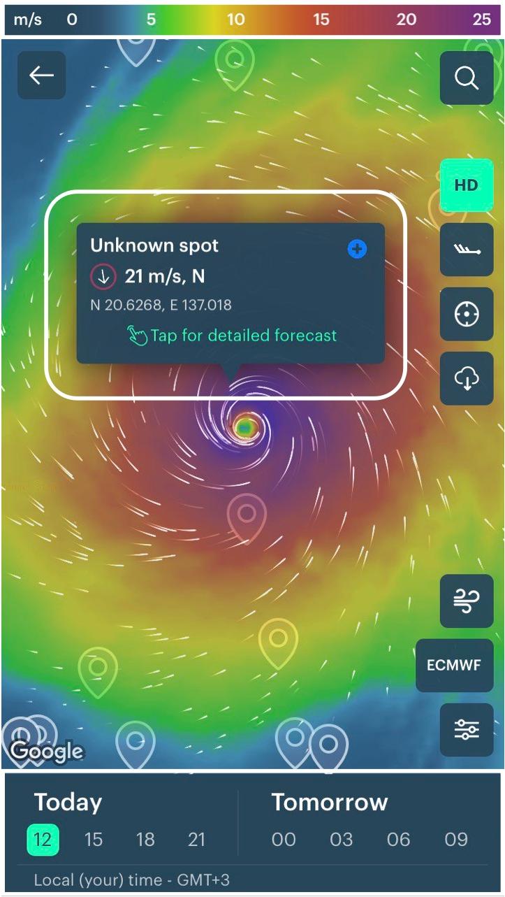
Check the weather forecast in your region in Windy.app for iOS and Android.
In the app you see then same tracker and live map. Do the same to find out where the hurricane is now, and how strong it is. Use many additional app features: 4x larger HD map, Wind Bards, Offline Mode, Wind Gusts, Precipitation, Weathter Models, and different Views of the Map, and other.
All new users living in the area of an active hurricane or typhoon get access to the free Pro version of the app on the time of hurricane or typhoon activity, so they can use professional tools to correctly evaluate weather conditions.
Professional Weather App
Get a detailed online 10 day weather forecast, live worldwide wind map and local weather reports from the most accurate weather models.
Compare spot conditions, ask locals in the app chat, discover meteo lessons, and share your experience in our Windy.app Community.
Be sure with Windy.app.


