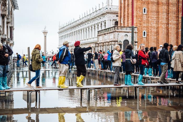
On November 13th, more than 85% of Venice was flooded.
The flood level hit a mark of 1.87 m. The critical level is considered to be at 1.3 m.
Two people died.
Italian government released 20 million euros in funds to tackle the devastation.
What is Acqua alta
«Acqua alta» is the term used to describe tidal peaks in the northern Adriatic Sea. The highest tides are registered in the Venetian Lagoon and consequently lead to the partial flooding of Venice.
October to January is the high water season. During this time Venice gives the impression of sinking.
The city can withstand the rise of water up to 1 m above sea level. However, when the water rises to 2 meters or more, the streets of Venice go underwater.
Acqua alta
Why is Venice flooded
There are 7 main reasons for floods in Venice:
The Venetian lagoon is shallow. Therefore, any changes in the sea level are reflected on the coast.
Winds. Northbound winds — bora and sirocco — often blow directly towards the harbors that connect the lagoon to the Adriatic Sea. Winds block the outflow of the water from the lagoon towards the sea. Therefore the ebb is isolated inside the lagoon. The following high tide overlaps the previous one.
Precipitation. Winter in the Mediterranean is usually rainy. Many alpine rivers have the potential to cause floods. Water flowing from the continent into the lagoon cannot reach the sea fast enough due to the three narrow straits.
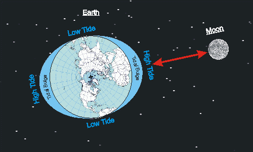
Tides. Let us explain tides. Tides affect the water level not only on the coast but also on the entire surface of the ocean. When the ocean level rises to its maximum it is called high tide.
The primary cause of tide formation is the gravity of Earth and that of the Moon. This leads to a peculiar hump and a wave forms on the water.
Tides
The second cause is the rotation of the Earth, a wave formed by the gravity pull of the Moon or the Sun changes its position relative to the globe. The wave follows the Moon, while the Earth continues to spin. This affects the constant movement of the water hump, which causes tides.
The good thing is that tides can be predicted years in advance.
Tides are amplified by a phenomenon such as seiche. A seiche is a standing wave in an enclosed or partially enclosed body of water. You can watch this phenomenon in your own bath. If you excite the water, then the wave begins to run back and forth. Seiches have been observed in the Adriatic Sea.
Global warming and the progressive rise of sea levels. Some experts say that by 2100 seawater will fully cover the Adriatic coastline because of global warming.
Subsidence or the natural sinking of the soil level. The city in the lagoon continues to sink by an average of 1-2 millimeters per year. Some scientists believe that this is due to the compaction of the soil under its own weight and the weight of the city. Others believe that the reason is tectonic vibrations of the Earth's crust. Another significant reason is the pumping of groundwater. For a long time, the city used fresh groundwater.
Infrastructure. The industrial area of Porto Marghera lies immediately behind Venice on the small islands. These islands have previously acted as natural sponges during high tides, absorbing a significant amount of water.
Moreover, the "Oil Channel" was built through the lagoon to allow oil tankers to reach the piers. It created new direct connection to the sea, so the city is more affected by severe high tides.
Flood in 1966
On November 4, 1966, high tides, three days of heavy rain and sirocco wind caused the water in the canals to rise to a mark of 194 cm. It was the worst flood in the history of Venice.
Thousands of citizens were trapped in their homes for days. Artworks valued at a total of $6b perished.
You can publish your own post in Windy.app's blog. Click here.
Windy.app is a professional weather app, created for water and wind sports and all outdoor activities.
Get a detailed online 10 day weather forecast, live worldwide wind map and local weather reports from the most accurate weather models.
Compare spot conditions, ask locals in the app chat, discover meteo lessons, and share your experience in our Windy.app Community.
Be sure with Windy.app.