
Here are the top four Finnish national parks out of forty
Thanks to the truly wild nature and the developed tourist infrastructure, Finland is one of the best countries in Europe for hiking. But not only that. It is a great place for kayaking, skiing, fishing, mountain biking, and some other outdoor activities.
The first national park in the country was created back in the early 20th century, just after the first national park in the world, Yellowstone in the United States. Finns have picked up the bright idea of the Americans and successfully implemented it in their native land. Today Finland has 40 national parks, which is quite a lot for such a relatively small country compared to the US, where there are 63 national parks.
If you are not already a fan of Finland and have never been there, it can be difficult to navigate through such a variety of parks. But I am a fan and live here for the past 10 years. So I’ve chosen four of the 40 parks — the main one in each of four of the country’s large natural and tourist regions: Helsinki, Archipelago, Lakeland and Lapland — and I’ll tell about their main features and hiking trails in this article.

Ivan Kuznetsov, an outdoor writer from the Dolomites, Italy, and Karelia, Finland
Nuuksio National Park

Narahari-k-r / Unsplash
- Location: Espoo municipality, Uusimaa region
- Area: 55 sq km (21 sq mi)
- Founded: 1994
- Visitors: 330,600 (2019)
- Symbol: flying squirrel
Nuuksio National Park is the main national park in southern Finland.
The park is located in the municipality of Espoo in the Uusimaa region, the capital of which is the largest city of Helsinki, which is also one of the four major tourist regions of the country. The distance from the city to the park is 38 km. Because of its proximity to the Finnish capital, the park is the most famous and popular in the country, because not many people get to its more remote parts, including Lapland.
The main feature of the park is the Haltia Nature Museum, located on its southern borders, where you can learn all about not only this region but all the others. The museum is also considered the largest of more than a dozen such museums in the country. The building is also known for being the first completely green building in Finland: it is built of wood, powered by solar energy, collects rainwater, and so on.
The park has about a dozen marked hiking trails, the longest of which is Korpinkierros, 8 km long, which runs around picturesque forest lakes with small climbs and descends to and from the granite rocks in the central part of the park.
Practical information
- You can get to the park directly from the center of Helsinki, first by train and then by bus. Travel time is no more than 2 hours.
- The Haltia Nature Center is also the visitor center of the park, which is located at Nuuksiontie 84, 02820, Espoo.
- When hiking in the park you can pitch a tent in one of the specially equipped places, use lean-to shelters or rent one of the two huts for 6–8 people in advance.
Get the weather forecast for Helsinki, Finland
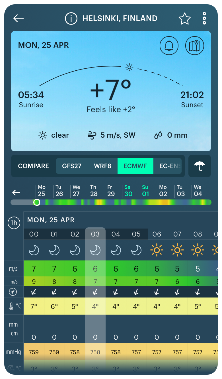
Weather forecast for Helsinki, Finland
Archipelago National Park

Sanna Linjos / Unsplash
- Location: Turku, Southwest Finland
- Area: 500 sq km (190 sq mi)
- Founded: 1983
- Visitors: 72,600 (2019)
- Symbol: eagle
Archipelago National Park is the main national park in southwest Finland.
It is the natural and tourist region of the same name called Coast and Archipelago, which also covers the entire sea coast of the country. Administratively, the park belongs to the municipality of Turku in the Southwest Finland region. You can say that the park starts right in the city limits because the city is also located on its islands.
The main feature of the park is numerous rocky islands and picturesque straits and bays, which form, in the Archipelago Sea in the Bothnian Bay of the Baltic Sea. The archipelago is considered to be the world’s largest archipelago by a number of islands — over 40,000 in total, of which about 2,000 are in the territory of the park itself.
Given that the park is located entirely on islands, there aren’t many hiking trails, let alone long hiking routes. But the park is known for the Archipelago Trail of the same name. It is an automobile and (more importantly for us) bicycle route through its main islands up to 250 kilometers long, which can be traveled in a few days, moving between islands by ferries. Nevertheless, on some islands of the park, you can walk up to 5 km on trails.
Practical information
- The park can be reached by bus or ferry from Turku, which in turn can be reached by train or bus from Helsinki. Be careful: transport links exist only between the largest islands and are more active in the summer season.
- The main visitor center of the park is called Skärgårdscentrum Korpoström, it is located on one of the islands at Korpoströmsvägen, 832, 21720, Korpoström.
- When hiking and traveling in the park, you can stay in one of the equipped campfire sites. The park also has three open wilderness huts on Konungsskär, Notvarpharun, and Gärskär islands for 2–4 people each.
Get the weather forecast for Rajakari, Turku, Finland
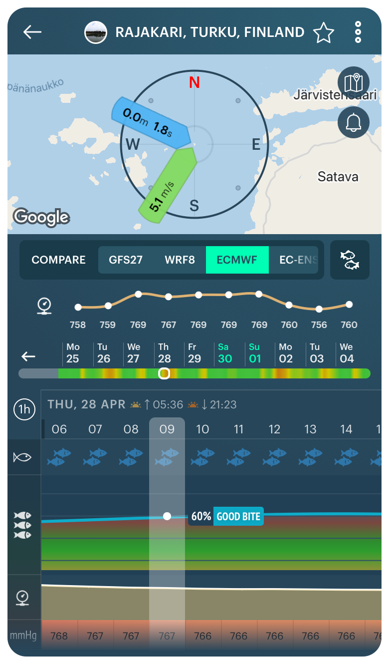
Weather forecast for Rajakari, Turku, Finland
Koli National Park

Panu Turunen / Unsplash
- Location: Joensuu municipality, North Karelia region
- Area: 30 sq km (12 sq mi)
- Founded: 1991
- Visitors: 201,800 (2019)
- Symbol: slash-and-burn agricultural landscape against the backdrop of the Kohli hills at sunset
Koli National Park is the main national park in the east of Finland.
The eastern part of the country is also the large natural region known as Finnish Lakeland. It is this part of the country — not Helsinki, the archipelago, or even Lapland — that the locals themselves and travelers associate with Finland most notably. The park is located on the shore of Finland’s fifth-largest lake Pielinen and belongs to the municipality of Joensuu, the capital of North Karelia.
The main feature of the park is the spectacular views of the lake, the islands in it, and the endless pine forests from its three highest peaks: Ukko-Koli (347 m / 1,138 ft), Akka-Koli (338 m / 1,109 ft), and Paha-Koli (331 m / 1,086 ft). These three granite cliffs are also the highest in all of southern Finland and belong to the non-existing Karelides Mountains, which were once as high as the Alps. This view is so beautiful that it is among the 27 national landscapes of Finland.
The park has a huge variety of hiking trails, the most famous and longest of which, the Herajärvi Trail, runs throughout the whole park. Its length varies from 30 to 60 km, depending on the route you choose. You can also walk the entire park from north to south or vice versa.
Practical information
- The quickest way to get to the park is to take a local bus from Joensuu. You need to get off at the Ahmovaara stop, from which it is another 10 km to the park. Transport does not go through the park itself. To overcome them you can hire a shuttle bus or hitchhike.
- The park visitor center, which is also a Koli Nature Center Ukko is located at the foot of the above-mentioned hills at Ylä-Kolintie, 39, 83960, Koli (Lieksa).
- You can spend the night in the park at one of the campfire sites, where you can use your own tent, or rent one of 11 huts. Right by the hills, there is also a luxurious hotel Break Sokos Hotel Koli.
Get the weather forecast for Joensuu, Finland

Weather forecast for Joensuu, Finland
Pallas-Yallastunturi National Park

Jaanus Jagomagi / Unsplash
- Location: Enontekiö, Kittilä, Kolari, and Muonio municipalities, Lapland region
- Area: 1,020 sq km (390 sq mi)
- Founded: 2005
- Visitors: 561,200 (2019)
- Symbol: wild birds on the backdrop of the Lapland hills
Pallas-Yallastunturi National Park is the main national park in the north of Finland.
It is also Finland’s most popular national park in terms of visitor numbers and is located in Lapland, the last of the country’s four main natural and tourist regions. More precisely, the park is located in the west of the region almost on the border with Sweden. The distance from the regional capital Rovaniemi to the park is 215 km.
The main feature of the park is a series of seven hills that make up the small mountain chain Pallastunturi, the highest and most famous of which is Taivaskero (809 m / 2,654 ft). The entire chain is famous for its magnificent scenery, which opens from its summits to the vast expanses of Lapland. Just like the view at Koli, this place is listed as one of Finland’s 27 national landscapes. The second most famous peak of the park, Yallastunturi (719 m / 2,358 ft), is located to the side and is a major ski resort with the same name Yallas.
Throughout the whole area of the park runs the most famous trail in all of Lapland called the Hetta-Pallas Hiking Trail of 50 km long in one direction. You can also do cross-country skiing in winter following this trail.
Practical information
- The park can be easily reached from Rovaniemi by buses, which run year-round. The city, in turn, can be reached by direct flight from Helsinki.
- The park has three large visitor centers in different parts: Pallastunturi Visitor Centre at Pallastunturintie, 557, 99330, Pallastunturi (Muonio); Yllästunturi Visitor Centre at Tunturintie, 54, 95970, Äkäslompolo (Kolari); and Fell Lapland Visitor Centre at Peuratie, 15, 99400, Enontekiö. The latter is the main center of the entire Lapland region.
- In addition to overnight accommodation in tents available throughout Finland, in the national park, you can stay overnight in one of the 22 always open wilderness huts, or rent a place in one of them in advance or an entire hut.
Get the weather forecast for Pallastunturi, Finland

Weather forecast for Pallastunturi, Finland
Text: Ivan Kuznetsov, an outdoor journalist, editor and writer from the Dolomites, Italy, and Karelia, Finland, with 10 years of professional experience. His favorite sports are cycling, hiking and sauna. Read his other articles
Cover photo: Unsplash
You will also find useful
Feature: Routes with weather at each point for sailing, cycling and hiking
Get the weather forecast for all US national parks ranked by your Google search
How to enjoy hiking in the rain. Tips from the (bad) weather experts
How to avoid a snowfall when winter hiking the mountains
The guide to Teide National Park — the most popular one in Spain
Latest News
Professional Weather App
Get a detailed online 10 day weather forecast, live worldwide wind map and local weather reports from the most accurate weather models.
Compare spot conditions, ask locals in the app chat, discover meteo lessons, and share your experience in our Windy.app Community.
Be sure with Windy.app.


