How the temperature changes in the Mediterranean Sea
Relatively similar conditions along the shores of the Mediterranean Sea have probably helped ancient civilizations to form close cultural and historical bonds. Despite the obvious similarities, however, there are plenty of differences, such as, the temperature of the water, which we will talk about today.
Temperature in general
The average summer temperatures in the Mediterranean region are quite high, so the water evaporates quickly. Precipitation and the rivers that flow into the Mediterranean Sea account for only one-third of all evaporating water; and as a consequence, the sea gets the rest from the surface water of the Atlantic Ocean.
The Mediterranean Sea comprises two deep basins: western and eastern. The western basin includes the territory from Cape Trafalgar and Gibraltar, where the sea meets the Atlantic Ocean, to the strait between Sicily and Tunisia. The eastern basin stretches from the eastern coast of Italy to the coast of Israel, Lebanon and Syria.
The water in the eastern basin is warmer than in the western one, partly because the уastern basin is located further to the south. Its corresponding latitude is 34o N, while the parallel of 40o N latitude runs through the middle of the western basin.

Ice is probably the last thing you imagine when you think of Venice. It is extremely rare but it does happen.
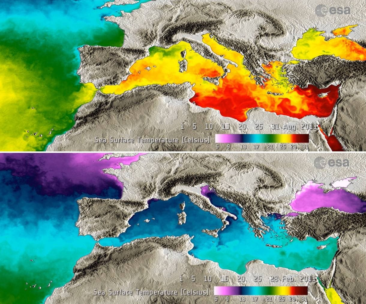
The highest temperature of the Mediterranean has been recorded off the coast of Libya, in the Gulf of Sidra. In August, the sea water reaches the whooping temperatures of 31 °C (88 °F). Sidra is closely followed by the Gulf of Iskenderun, Turkey. The average water temperature in the easternmost point of the Mediterranean Sea in August is 30 °C (86 °F).
The lowest water temperatures are found in the north of the Adriatic Sea close to Venice and Trieste, Slovenia. In February, the average water temperature there is as low as 5 °C (41 °F), and even ice occasionally forms in the Gulf of Trieste.
Generally, there is around 10°C range between winter and summer average temperatures in the Mediterranean.
Temperature in particular
It would be wrong to assume that the differences in water temperature are always dependent on their more northerly or more southerly location. The image below shows that the southern coast of France, particularly the Gulf of Lion, where Marseille is located, is significantly colder than the more northern, Italian part of the western basin.

Mediterranean Sea surface temperatures on August 15 (top) and February 15 (bottom) in 2011. Image: ESA / Medspiration
This is where the influence of currents comes into play. Warm water entering the sea through Gibraltar first flows along the northern coast of Africa and gradually reaches the Strait of Sicily, where it splits: a part of the surface water goes further east, while another part circulates along the western coast of Italy.
This relatively warm current gradually cools down. Italian shores are blessed with warm surface water but by the time the same water reaches the Gulf of Lion, it has already cooled down to the temperatures shown in the picture above. Another important factor that influences the temperature of the water in the bay include upwelling (strong winds drive warm surface water into the sea, forcing colder water to rise from the bottom) and the Rhone River, which flows into the sea here.
Complex currents, upwelling and other factors contribute to the temperature difference in surface water throughout the Mediterranean. Below you can see the average temperature in some regions of the sea by month.
- Alexandria. January — May temperature: 18–20 °C, June — December temperature: 23–26 °C. Average: 21.4 °C
- Antalya. January — May temperature 17–21 °C, June — December temperature: 22-28 °C. Average: 21.8 °C
- Athens. January - May temperature 15-18 °C, June - December temperature 19-24 °C. Average 19.3 °C
- Barcelona. January - May temperature 13-17 °C, June - December temperature 15-25 °C. Average 17.8 °C
- Venice. January - May temperature 10-18 °C, June - December temperature 14-26 °C. Average 17.4 °C
- Gibraltar. January - May temperature 15-17 °C, June - December temperature 17-22 °C. Average 18.4 °C
- Larnaca. January - May temperature 17-20 °C, June - December temperature 19-27 °C. Average 21.7 °C
- Malta. January - May temperature 15-18 °C, June - December temperature 19-26 °C. Average 19.9 °C
- Marcel. January - May temperature 13-16 °C, June - December temperature 14-22 °C. Average 16.6 °C
- Naples. January - May temperature 14-18 °C, June - December temperature 16-27 °C. Average 19.3 °C
- Tel Aviv. January - May temperature 17-21 °C, June - December temperature 20-28 °C. Average 22.1 °C
Text: Windy.app team
Cover photo: Osman-Yunus-Beckan / Unsplash
You will also find useful
What Is Thermohaline Circulation
How Do Bioluminescent Waves Occur
The 2022 Atlantic Hurricane Season is expected to be above-normal according to the NOAA's Outlook
Latest News
Professional Weather App
Get a detailed online 10 day weather forecast, live worldwide wind map and local weather reports from the most accurate weather models.
Compare spot conditions, ask locals in the app chat, discover meteo lessons, and share your experience in our Windy.app Community.
Be sure with Windy.app.


