How anvil clouds form
What is an anvil cloud?
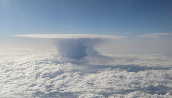
Sometimes a mass of warm air can rise to such a height that it encompasses the entire lower layer of the earth’s atmosphere (that is, the troposphere). Such monsters grow to 15-18 km up.
At an altitude of about 15 kilometers (in different latitudes differently), there is the tropopause.
The tropopause is the boundary between the troposphere and the stratosphere.
In the troposphere, located below, the temperature gradually decreases with increasing altitude (0.5-0.7 ° C every 100 meters). In the tropopause, the temperature slide noticeably slows down, to about 0.2 ° C / 100 m.
In the tropics, the tropopause is located at an altitude of 15-18 km, and at the temperate and polar latitudes — at an altitude of 7-12 km. In some places, the width of the layer is two hundred meters, and somewhere it reaches three kilometers.
When it reaches the tropopause, the cloud stops growing and, due to strong winds at this height, begins to blur, forming the shape of an anvil cloud.

The shape of the anvil is visible from afar and portends a barrage of wind.
The density of warm air is less than the density of cold air. Because of this, cold air drops down. Then, hitting the surface of the earth, it continues to move horizontally by inertia. This process can be observed at home if you open a window on a cold day. Cold air from the street will go down and spread along the floor. In nature, these streams form squall winds.
A squall is a sudden sharp increase in wind. A squall differs from a hurricane by its brief character (usually about a minute).
The wind speed in a squall can exceed 40-50 knots (20 m / s).
Text: Windy.app team
Cover photo: Unsplash
You will also find useful
Where does the downpour come from
Latest News
Professional Weather App
Get a detailed online 10 day weather forecast, live worldwide wind map and local weather reports from the most accurate weather models.
Compare spot conditions, ask locals in the app chat, discover meteo lessons, and share your experience in our Windy.app Community.
Be sure with Windy.app.


