
What is cloud top and how else do we measure clouds
Cloud top is a well-known weather parameter for outdoors enthusiasts who engage in a various wind sports in the air — for example, paragliders but not only them. If you haven't tried this or other air sports yet but want to do, this article is right for you.
Learn what the cloud top is, why you may need it, how else do we measure clouds, and how to use it all for your outdoor activity.
What is cloud top?
A cloud is the tiny liquid particles of water vapor, frozen water crystals, and other particles suspended in the air. Clouds form in the sky because the air becomes saturated with moisture when it cools to the dew point, or when much water evaporates from the earth's surface and water vapor forms.
The cloud top is the height at which the upper visible part of the clouds is located as opposed to the cloud base, which is the lower visible part. So it is measured with the same instrument we use to measure the base of the cloud called a “ceilometer” or a type of atmospheric lidar. Its working principle is based on the laser. We also measure cloud top with the same units as cloud base, although sometimes not meters or feet, but hectopascal (hPa) as the corresponding pressure level.
The concept of a cloud top is opposite to the concept of a cloud base, but they are related. The height of the cloud top is often more variable than the height of the cloud base. It is also at the top and not at the base that rain, snow, sleet, and other types of precipitation form.
Knowing cloud top is useful for anyone who practices various wind sports and outdoor activities in the air, such as paragliding, parachuting, air ballooning and different types of aviation. It helps you navigate and avoid loss of visibility, which is vital weather element in the air. But you don’t have to be a paraglider to see top of the clouds. Mountaineers and even many hikers often climb above the clouds because they often lie so low that they are below the tops of the mountains. In this situation you are sure to find yourself in clear and cloudless weather without precipitation. Plus, you can take stunning photos like this one:

Clouds under the top of the mountains. Photo: Samuel Ferrara / Unsplash
How else do we measure clouds?
Clouds are measured not only by this weather parameter but by several others. Here we will mention them very briefly, and later we will talk more about each of them in the separate articles. But if you see a link, there is already one, so go to learn more about it:
- Cloud formation is an understanding of the very nature of the process of cloud formation in different layers of the atmosphere and in all the variety of cloud types.
- Cloud type is a kind of clouds in the general classification of clouds by their formation, size, shape, composition, height above the ground, and other parameters.
- Cloud base or the base of the cloud is the altitude of the lowest visible part of the cloud, answering the question of how high the clouds are from the Earth.
- Cloud top is the altitude of the top of the visible part of the cloud as opposed to the cloud base but they are also related to each other in many ways.
- Cloud height is the distance between the base of the cloud and the top of the cloud, which is also called cloud thickness or cloud depth.
- Cloud level is the altitude at which the clouds are located according to cloud base, expressed as a range, for example, between 2 and 5 km above the ground or the sea level.
- Cloud layers is a set of clouds, which are usually of one or more types, and are located at the same altitude above the ground or the sea level, separated by a certain minimum distance.
- Cloud ceiling is the height of the base of the lowest visible clouds, which should cover more than half of the sky, and shouldn't be confused with the cloud base.
- Cloud cover or cloud amount is total part of the sky covered by clouds expressed as a percentage, although it was a special symbol on paper weather map before.
- Cloud reflectivity or cloud albedo is the ability of the cloud to reflect sunlight and not allow it to reach the ground in whole or in part.
- Cloud feedback is the effect of changes in surface air temperature on clouds and vice versa, i.e. the relationship between the two weather elements.
- Сloud forcing or cloud radiative effect (CRE) is the difference between the Earth's radiation (energy) budget components for average cloud and cloud-free conditions.
- Cloud seeding is the artificial alteration of processes within clouds by adding reagents into them from aircraft as an attempt to regulate precipitation.

How do we measure clouds. Valerya Milovanova / Windy.app
Where to get clouds forecast?
The forecast of clouds is one of the main in the Windy.app, along with the wind speed and direction, air and water temperatures, precipitation and other forecasts. Of all the above types of cloud measurements, you can find two in the app: cloud base and cloud cover (clouds).
Cloud base
You can find the cloud base parameter in a special weather profile for all wind sports in the air called the same — "Air". To do so:
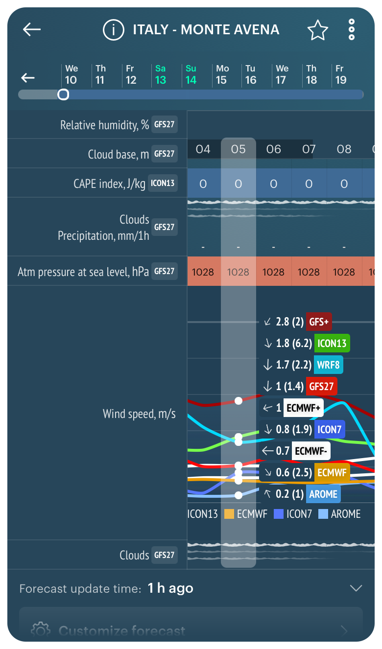
1. Open your favorite or nearest spot from the Home Screen of the app or from the Weather Map. Let's take the Monte Avena paragliding spot located in the Dolomites mountains in Veneto region in Italy, as an example. It is a fairly flat mountain that is easy to jump from. The height of this mountain is 1,450 m (4,770 ft) above sea level.
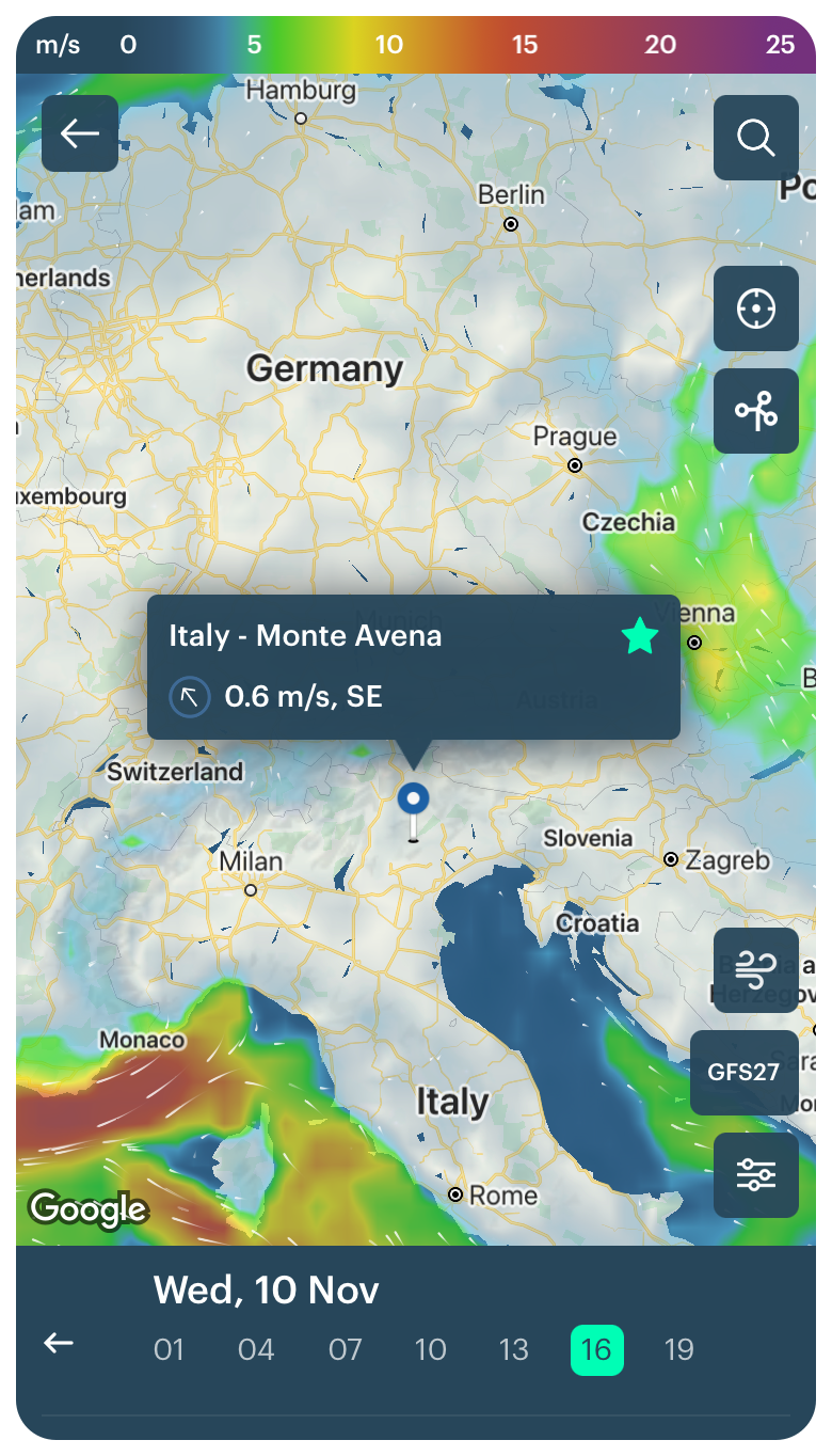
Monte Avena paragliding spot in the Dolomites, Italy, in the Windy.app for iOS
2. Select the Air Weather Profile using the icon to the right of the weather models:
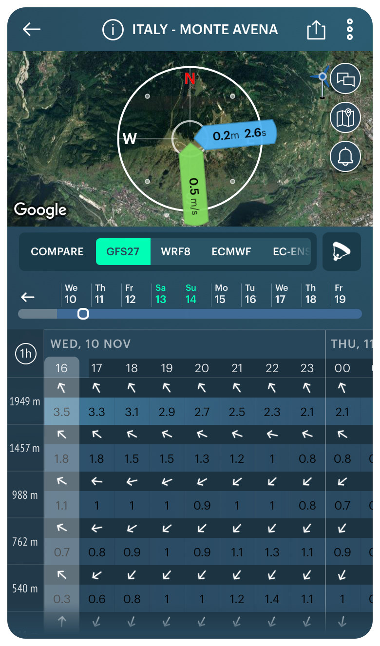
Air Weather Profile in the Windy.app for iOS
3. Get a cloud base forecast for today as well as for the next 10 days. You can also change the forecast step from 1 to 3 hours.
On the date of the writing of this particular text, in the forecast we see that the maximum cloud base on Monte Avena in the next three days will be 3,200 m (10,498 ft) on Friday, November 12 at 7 am, and the minimum cloud base will be 1,100 m (3,608 ft) on Saturday, November 12 at 08 am.
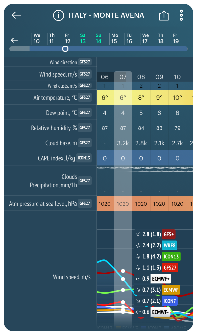
Maximum cloud base for Monte Avena in the Dolomites, Italy, in the Windy.app for iOS
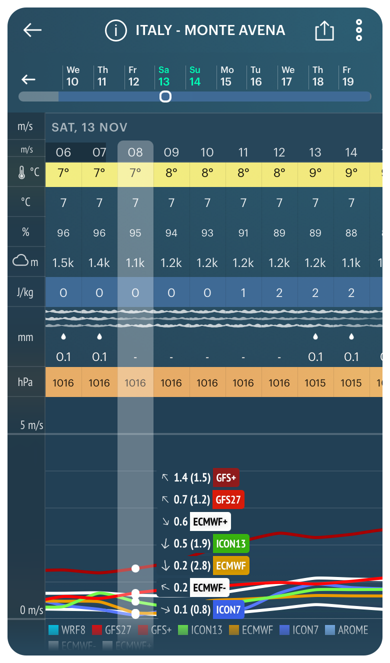
Minimum cloud base for Monte Avena in the Dolomites, Italy, in the Windy.app for iOS
This means that at the minimum cloud base the clouds will cover the highest point of the mountain, so jumping on that day and at that time may be problematic.
Looking at the forecast for many days, you can also calculate the average base of clouds for the spot by yourself. This is somewhere around 1500–2000 m (4,921–6,561 ft).
Clouds (cloud cover)
The cloud cover is available in the same Air Weather Profile, as well as in all other 10 weather profiles according to all 10 weather models in the application under the general name “Clouds”.
Cloud cover in the Windy.app for iOS
In contrast to the common expression of the parameter in percentages or oktas on weather maps, in the Windy.app you see a graph with layers of clouds. It can be one layer, two layers, or three layers — but no more, or no layers at all.
- One layer means few clouds — up to 50% cloud coverage of the sky
- Two layers — middle amount of clouds — about 50% cloud coverage
- Three layers — lots of clouds — more than 50% cloud coverage
- No layers — no clouds — 0% or so of the sky is covered by clouds
The number of layers also literally shows how many layers of clouds are in the sky in a system of three main layers, which refers to the clouds layers parameter.
Pay attention also to the color and thickness of each layer itself, I mean, the line. The darker it is and the thicker it is, the more clouds are in the sky and the denser the layer. And vice versa: the lighter and thicker the line, the thinner the layer, and the fewer clouds in the sky.
In any case, before you get in the air to do your favorite wind sport, check the forecast by different models, as well as just visually on the day of your trip.
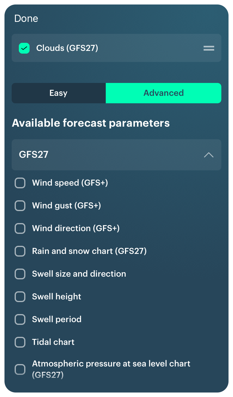
Last but not least, you can select the Clouds forecast as a separate item and add it to your Custom Weather Profile using the Cusmotization feature. To do this, go to the Weather Profiles Screen and select it in one of the models. Then check the forecast.
Adding cloud cover on the Weather Profile Screen in the Windy.app for iOS
Learn more about clouds in the Windy.app Meteorological Textbook.
Text: Ivan Kuznetsov, an outdoor journalist, editor and writer from the Dolomites, Italy, and Karelia, Finland, with 10 years of professional experience. His favorite sports are cycling, hiking and sauna. Read his other articles
Cover photo: Raman Balakrishnan / Pexels
You will also find useful
What is cirrus uncinus clouds. Simple explanation
Latest News
Professional Weather App
Get a detailed online 10 day weather forecast, live worldwide wind map and local weather reports from the most accurate weather models.
Compare spot conditions, ask locals in the app chat, discover meteo lessons, and share your experience in our Windy.app Community.
Be sure with Windy.app.


