
What is the dust storm and how does it work
In a nutshell: a dust storm occurs when a strong wind (more than 10 m/s) makes a huge amount of dust rise up into the atmosphere - millions of tons! This dust can be transported up to several thousand kilometers. In this new lesson of the Windy.app Meteorological Textbook (WMT) and newsletter for better weather forecasting you will learn more about dust storm and how it works.
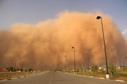
Dust storm
Where does the dust come from?
Imagine the soil in a forest or a field. Plants, in particular their roots, strengthen the soil and help it retain moisture. Moisture makes soil particles heavier and binds them together, just like water and flour do. The stems and leaves of plants are, so to speak, a blanket that protects the soil from wind and sunlight.
But there are areas on our planet where nothing grows (or barely does). These are deserts and semi-deserts. There is very little moisture in the air, so the soil is also dry.
Dry soil is like flour — light and loose, and if you blow on it, it scatters in different directions.
When the wind speeds up over bare dry soils (and it also speeds up due to the lack of trees and other plants), loose soil particles begin to vibrate: first, a little, and then, after speeding up, “jump”. When these particles repeatedly hit the ground and each other, they create fine dust.
1.jpg)
Bare dry soils
How does a storm appear
Something like a dust storm can be seen when you go into the water from a muddy bank and it starts to blur as the silt rises from the bottom.
When the wind rises the dust from the ground, it continues to rise into the atmosphere because of so-called convection currents — warmer and lighter air from the heated surface rises upwards as long as it is surrounded by colder air.
From there, all this dust is carried by the wind in a layer several meters to several kilometers high. An interesting thing happens regularly when the dust is transported from the Sahara to the west across the Atlantic Ocean.
The surface of the desert warms up during the day and this contributes to the rise of air (convection), and with it — dust particles. When the air mass enters the ocean, it is above a colder and wetter atmospheric layer. Cold air is below warm air, which means it is not able to rise. As a result, the warm and cold layers do not mix, and this allows the dusty layer of air cross the entire ocean and get to America. There, the dust either simply settles or is washed out of the atmosphere with precipitation. Usually, there is a period of several hours to 10 days between the moment the dust rises and the moment it settles.
You’d think a dust storm would do nothing but harm — bad visibility, traffic disruptions, trouble breathing, etc. But in Hawaii, for example, the dust helps banana cultures grow! And in the Caribbean sandy beaches grow...
Yes, in addition to dust storms there are also sandstorms. The difference is that the latter occurs in sandy deserts, and wind, in this case, carries not only dust but also larger particles of sand (particle diameter for comparison: dust < 0.1 mm < sand < 5 mm).
It is possible to predict dust or sandstorms — to do this you need to predict a strong wind over an area with exposed dry soils. Strong thunderstorms often cause dust storms, as they are associated with stronger winds.
Text: Windy.app team
Cover photo: Unsplash
You will also find useful
What Is a Dust Devil And How Does It Work
Latest News
Professional Weather App
Get a detailed online 10 day weather forecast, live worldwide wind map and local weather reports from the most accurate weather models.
Compare spot conditions, ask locals in the app chat, discover meteo lessons, and share your experience in our Windy.app Community.
Be sure with Windy.app.


