
When Fire Rises Above the Clouds
What could be worse than a tornado? Only a tornado made of fire—kilometers high, consuming entire cities. Today, we’re going to talk about how these terrifying phenomena form.
Children of Fire
Ordinary tornadoes begin in the sky. Clouds swirl due to differences in wind speed and direction, forming a funnel that rotates and stretches toward the ground.
With fire tornadoes, it’s the opposite—they are born on the ground, in the heart of a fire, and reach upward toward the sky.
It all comes down to the enormous amount of heat that fires release, which drastically alters the movement of air around them. Remember: cold air is denser and heavier than warm air, and it always tends to rush in to replace warm air. That means large volumes of cold air are pulled in from all sides toward the fire.
Fire whirl in Missouri. Photo: Janae Copelin/Barcroft USA
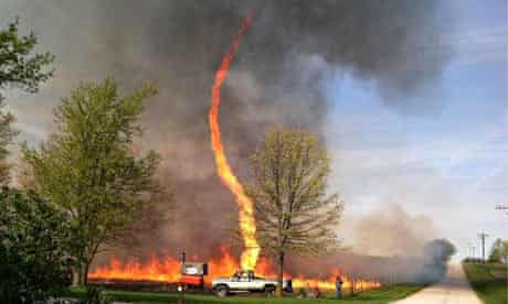
As a result, the fire draws in air from all directions. These multidirectional air currents cause rotation. Turbulence, pressure drops, and rapidly rising hot air combine—and the hottest part of the fire becomes a spinning column, filled with burning gases, branches, and debris.
The more intense the fire—that is, the hotter and wider it is—the stronger the winds, the faster the spin, and the higher and wider the column grows. Fire whirls are typically between 10 and 50 meters tall, and range from under a half meter to a couple of meters wide.
When there’s nothing left to burn inside, or the vortex collapses due to side winds or cooling, the fire whirl dissipates. These whirls usually last only a few minutes, and don’t cause major destruction on their own.
But not all fires are the same—some are much more powerful than others. And under the right conditions, a fire whirl can evolve into something far more destructive.
From Charmander to Charizard
While the media often mixes them up, scientists distinguish between two types: the fire whirls we’ve just described, and the far rarer fire tornadoes.
Fire tornadoes have the structure and power of regular tornadoes, and can last up to 30 minutes. They form from the most intense fires, and are connected to clouds that the fires themselves generate.
So how does a fire produce a cloud? Quite simply: the hot air from a fire rises rapidly, due to the extreme temperature difference with the surrounding air, and carries soot particles with it. Moisture condenses onto these particles high in the atmosphere, forming a brown or gray pyrocumulus cloud.
Fire tornadoes have been recorded only a handful of times. The largest one ever caught on camera appeared during the Carr Fire in California in 2018. The fiery column reached 5.5 kilometers in height, was about 300 meters wide, and had wind speeds inside it reaching 230 km/h (143 mph).

Fire tornado during the Carr Fire. It’s hard to believe that it all started with just a few sparks from a car tire igniting dry grass. Photo: California Department of Forestry and Fire Protection
In terms of destruction, the Carr Fire was not the worst case: while three people died, it is believed that the 1923 fire tornado in Tokyo—triggered by the Kanto earthquake—killed over 30,000 people in just 15 minutes. However, it remains difficult to determine how many of those deaths were caused by the tornado itself, and how many were due to the widespread fires and the earthquake.
Fire tornadoes can also occur during volcanic eruptions, major urban or forest fires, and especially following large-scale bombings, including nuclear explosions. They were witnessed during World War II in Hamburg, Dresden, and of course, Hiroshima.
Due to the high concentration of soot particles rubbing against each other in the air, fire tornadoes can even generate lightning through static electricity buildup.
Scary? Definitely. Preventable? Often.
Many fires are avoidable. Let this article serve as a reminder to follow simple forest safety practices—extinguish campfires properly, and never leave cigarette butts behind. Even if dramatic fire tornado photos don’t convince everyone....
When it comes to fighting wildfires, accurate weather forecasts are critical for effective containment and saving lives. For example, low humidity and high temperatures signal more intense burning, while wind direction and speed help predict the fire’s spread.
The PRO version of Windy.app offers a wide range of advanced weather models, including hyperlocal ones, along with detailed maps, weather station data, radar imagery, and more to improve forecasting.
For several years, we’ve been offering free access to PRO for those who use it to protect people and the environment. If you work in firefighting, just open the Windy Care section in the app’s main menu and tell us about your work.
Text: Jason Bright, a journalist and a traveller.
Cover photo: Ivan Prokhorov / Unsplash
Read more:
What is a tornado and how does it form
What are hurricanes, and why do they occur in a certain season
Latest News
Professional Weather App
Get a detailed online 10 day weather forecast, live worldwide wind map and local weather reports from the most accurate weather models.
Compare spot conditions, ask locals in the app chat, discover meteo lessons, and share your experience in our Windy.app Community.
Be sure with Windy.app.


