
What is a tornado and how does it form
Today we are going to look at tornadoes, one of the most dramatic and violent weather conditions.
What is a tornado?
A tornado is a rotating column of air with low pressure at its centre. The most violent tornadoes with wind speeds of up to 130 m/s are capable of tremendous damage. It’s not surprising that they can tear entire towns apart.
The appearance of tornadoes is always associated with cumulus clouds, which distinguishes them from other vortices similar in appearance, such as dust devils which we have already discussed.
Tornado sizes vary greatly. A typical tornado is several hundred metres high. The upper edge of a tornado is easy to spot as it is within the cloud it originates from. The width of a tornado funnel on the ground usually ranges from 5 to 30 meters, while the largest ones can reach several kilometers. They last from several minutes to several hours, and sometimes manage to travel dozens of kilometers before dying out.

A pair of tornadoes barrel toward Pilger, Neb., on June 16, 2014. Eric Anderson / AP
The types of tornadoes
Tornadoes are usually classified according to maximum wind speed, but measuring wind speed in a violent vortex is a challenging and often dangerous task. Weather stations are not suitable for the task as one might wait for years until a tornado hits that particular area. As a consequence, in the United States “tornado hunting” is popular both among scientists and weather enthusiasts who drive around the country in search of tornadoes using specialist tools and equipping their cars with protection systems against the strong winds and flying debris. The data they collect in the middle of the storm makes a huge contribution to the study of tornadoes. Unfortunately, sometimes such endeavours end in tragedy.
Due to the difficulties in measurements, tornadoes are often ranked by the damage they cause using the Enhanced Fujita scale. EF0 tornadoes on the scale cause minimal damage, while EF5 are considered devastating. The most violent tornadoes rip apart brick and stone houses, destroy bridges and flyovers, pick up heavy trucks and drop them over a kilometer (mile) away. Each point of the scale is based on the estimated wind speed of the tornado.
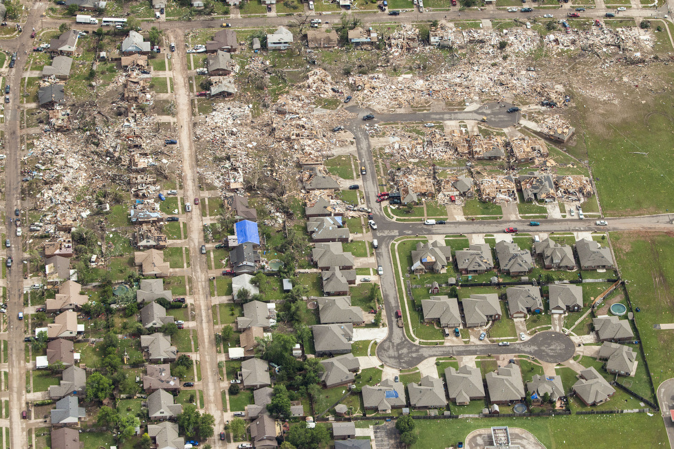
An aerial view of the destruction caused by the massive tornado that struck areas south of Oklahoma City, 2013. Photo: David McNeese / CNN
So let’s take a look at two main types of tornadoes:
- Supercell tornadoes come from ‘supercells’, large thunderstorms with a rotating updraft.
- Non-supercell tornadoes are formed in actively growing cumulus clouds, where the size of the cloud isn’t really important; the key is that it is still growing
Interestingly, there are more differences than similarities between these. They form in places using different mechanisms and under different weather conditions. We will now explain more details of the process of tornado formation.
How do tornadoes form?
For a tornado to form, two elements are crucial: cumulus clouds and severe vertical wind shear.
1. Cumulus clouds. They develop as the surface of the earth gets very hot. In polar regions, for instance, the surface is never warm enough for cumulus clouds so tornadoes are extremely rare there.
On the contrary, in temperate and tropical climate, cumulus clouds and tornadoes are quite common.
There are several reasons why cumulus clouds form. One of them is the unstable stratification of the atmosphere when cold air meets a heated surface. In temperate climate, this situation is quite common. If the temperature difference is large, and there is a lot of water vapour in the atmosphere, cumulus clouds can develop into cumulonimbus clouds; these are over 10 km in height and 15 km in diameter.
The United States environment provides ideal conditions for the collision of cold and warm air. Powerful cumulonimbus clouds are often observed in this region making it a perfect place for over a thousand tornadoes every year. Tornadoes also frequently occur in Europe, Bangladesh, parts of South America, Australia, New Zealand and China.
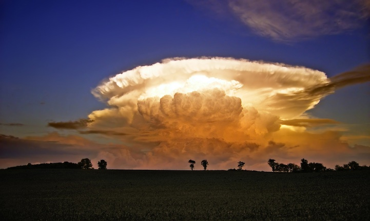
Beautiful cumulonimbus clouds
However, even in mid-latitudes this is not possible everywhere; Siberian summers for example, can be boiling hot, but cold air reaches there relatively rarely and the air humidity is low so cumulonimbus clouds and tornadoes are not common in that region.
In tropical regions, by definition, the air is warm; convection can be amplified by heat from the condensation of water vapour in a cloud. So, in tropical climates where there is plenty of water vapour, in combination with a very hot surface, it leads to the formation of the most powerful cumulonimbus clouds, which can be found at an altitude of 16 km. The development of cumulus clouds without cold air is possible in temperate climates, in most cases, occurring over heated water bodies, because the air above them is very humid. This is also possible over land if it’s really hot and humid.
Thus cumulus clouds necessary for the formation of tornadoes can therefore develop in tropical and temperate climate with these clouds forming in the following conditions:
- Cold air hits a warm surface (only in temperate climate)
- High humidity is combined with a very hot surface (both in tropical and temperate climate)
The cumulus cloud is the first element which is necessary for the development of a tornado. Now let’s consider the second element required for a tornado to form, wind shear and this has several forms.
2. Vertical wind shear. Vertical wind shear refers to the variation of wind speed and its direction with altitude. The wind near the ground might blow from the north, while at the same time at an altitude of 5km it can blow from the west. The greater the difference between wind speed and direction at different altitudes, the greater the vertical wind shear and the scale of wind shear can vary.
Wind shear is considered of a significant or large-scale magnitude when the main wind direction at an altitude of 10m is different from that at an altitude of only several kilometers. The most significant wind shear occurs where cold and warm air meet, for example, where cold air hits a warm surface.
Small-scale wind shear may occur for a number of reasons, such as the friction of air against the underlying surface. On the ground, air meets with trees, hills and other objects, whilst on the water it hits waves. Colliding with these, the wind can change speed and direction but at the same time, friction is not always felt over irregularities and the wind can still move freely. The difference between the wind at the height of irregularities and the wind above these result in small-scale wind shear.

Vertical wind shear. Illustration: Valerya Milovanova / Windy.app
This can be the cause of the formation of tornadoes in tropical and temperate climate, in the absence of cold air. It is clear that small-scale wind shear is present almost everywhere, not only under cumulus clouds but for the formation of a tornado a cumulus cloud is required.
Furtherr, we’ll look closely at the formation of tornadoes, but let’s briefly summarise what we’ve established so far:
Cumulus clouds can be divided into two types. Some are formed due to the ingress of cold air onto a warm surface. In clouds formed this way, large-scale vertical wind shear is very strong and they are found only in temperate climates. The second type of cloud is formed over a heated surface with high air humidity, and cold air is not required. There is always small-scale vertical wind shear underneath such clouds and they can form in both temperate and tropical climates. Looking ahead, these two types of clouds correspond to two different types of tornadoes.
Now it’s time to talk about how exactly a tornado forms:
Tornado formation in a supercell
A supercell is a very large and developed cumulonimbus cloud that, like a cyclone, has begun to rotate. How can this happen? We already know about the Coriolis force — it makes cyclones and anticyclones rotate. But in the case of our clouds, the rotation is of a different nature, because they are still too small for the Coriolis force to significantly affect them. The cause of supercell rotation is a large-scale vertical wind shear.
Wind shear can cause swirls to form, right inside a cumulonimbus cloud. Imagine a vortex lying on its side: the wind at its top and bottom will blow in the opposite direction.
Of course, wind shear in a real cloud can’t create such a beautiful and slender vortex, but a non-ideal one is enough. And the size of such vortices is quite large. Since a large-scale vertical wind shear is observed almost over the entire height of the cloud, and not in some small part of it, the resulting vortices occupy almost the entire cloud, and may even go beyond it.
Now let us recall again that a cumulonimbus cloud is formed by air currents rising from the ground. Reaching horizontal vortices inside the cloud, the rising air can interact with them. It can lift the vortices up, change the direction of their rotation, and destroy them. Or it can also turn them in such a way that these vortices will no longer lie on their sides, but “stand up” and get their usual orientation (the vertical axis around which the air rotates).
As we wrote above, these vortices are comparable in size to the cloud itself — and if they turn, they can make the entire cloud rotate. At that point, the cumulonimbus cloud becomes a supercell.

Tornado formation in a supercell. Illustration: Valerya Milovanova / Windy.app
The cloud rotates, and contact with it makes the air surrounding the cloud rotate as well. In particular, the air under the cloud begins to rotate. At the same time, some of the water droplets that make up the cloud are pulled down by rotation — a funnel (“tail”) appears directly under the cloud — this is the very first stage of formation of a future tornado.

Composite of eight images shot in sequence as a tornado formed in Kansas in 2016
And now let’s look at the supercell in more detail. We keep saying that air rises in cumulonimbus clouds. But it has to go down somewhere, too! Otherwise, all the air would go up from the ground and there wouldn’t be any air left below. It turns out that some of the air goes down right inside the cloud itself. In the rear part of the cloud, where there is no heavy precipitation, small hailstones that didn’t fall to the ground melt, and small droplets evaporate. Energy is spent on these processes, the air in this place cools, becomes heavy, and begins to descend.
Further development of the tornado will take place if in the area of our funnel (future tornado) there are powerful upward air movements (which once caused the cloud to form) and a strong wind blowing down from the cloud. The cold air comes down from above, and the warm air is at the bottom.

Development of the tornado in a supercell. Illustration: Valerya Milovanova / Windy.app
As in the cloud itself, we get unstable stratification, but already on a smaller scale, and with rotation as well. The upward movements of air intensify, and the pressure at their center becomes even lower (the pressure always drops when the air moves upward — we wrote about this in the article about cyclones). New air rushes into the low-pressure zone to fill the resulting void, and this leads to very strong winds. But it happens in such a way that the cold air is again above the warm air, and the upward movements, and with them the winds, only intensify. The longer the process lasts, the farther down the supercell rotation manages to penetrate, the funnel from the cloud continues to descend toward the ground. Eventually it touches the ground, merging with a zone of strong winds and low pressure — so the tornado appears.
The most important thing about this mechanism is that it is self-sustaining. As long as the supercell rotates and the air flows near the ground interact according to our scheme, the tornado will continue to exist. And it will dissipate only with the disappearance of one of the causes. It is also important to remember that this whole long and complex chain can be broken at any stage — the absence of any part of it is enough for the tornado not to form. That is why this phenomenon is so rare.
Tornado formation in a cumulonimbus cloud
It is not necessary for a cloud to rotate to form such tornadoes. Nor, accordingly, is a vertical wind shear within the cloud necessary. Any cumulonimbus cloud that is actively developing is sufficient. Therefore, it is critical that the underlying surface is very warm and humid, then the development of the cloud will be most interesting. This is why such tornadoes are most often formed over water, in warm tropical seas, and are called water tornadoes.
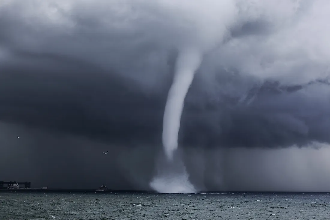
Waterspouts form over water bodies such as lakes, seas, and harbors
The formation of water tornadoes involves a small-scale wind shear observed right near the surface of the water. A horizontal vortex is formed near the surface (as in a supercell), and powerful upward air currents can make this vortex vertical, after that it touches the cloud, and a water tornado appears. Once on land, water tornadoes usually collapse quickly, so they rarely cause serious damage.
Once again, let’s remember how the two main types of tornado differ. Ordinary tornadoes are born inside a supercell due to its rotation and cold air sinking in it, and then descend to the ground. And water tornadoes are born under a cumulonimbus cloud due to wind friction against the underlying surface and then grow upward under the influence of rising air currents. By the way, water tornadoes can form not only over water, but also over wet areas of land. And not only water tornadoes can form over water, but also tornadoes in supercells (this requires cold air over very warm water). But such exceptions don’t scare us now! We know the difference between the two types of tornadoes and the conditions that lead to each.
People living in areas with frequent tornadoes almost always have a special bunker underground to wait out the bad weather. And sometimes they purposefully build houses of cheap materials — not to be sorry. Tornadoes pose a serious threat to your property and your life. If you see signs of this terrible phenomenon, be extremely careful. Look for shelter in the most solid constructions, preferably underground, and be careful.
Text: Evgeniy Petrov, a meteorologist and a climatologist
Illustration: Valerya Milovanova, an illustrator with a degree from the British Higher School of Art an Design (BHSAD) of Universal University
Cover photo: NOAA / Unsplash
You will also find useful
What are the main types of wind
The 2022 Atlantic Hurricane Season is expected to be above-normal according to the NOAA's Outlook
Latest News
Professional Weather App
Get a detailed online 10 day weather forecast, live worldwide wind map and local weather reports from the most accurate weather models.
Compare spot conditions, ask locals in the app chat, discover meteo lessons, and share your experience in our Windy.app Community.
Be sure with Windy.app.


