
Learn to read the Enhanced Fujita scale for rating tornado intensity
In North America, where tornadoes occur as regularly as heat waves, heavy rains, or snowfalls, the Enhanced Fujita scale is used to estimate their intensity. In this article, we’ll explain what this scale is about, how to read it, and where to find the tornado forecast to prepare for this phenomenon of severe weather.
What is the Enhanced Fujita scale?
The Enhanced Fujita scale is the primary and most common scale used to estimate the intensity of tornadoes in the United States and Canada based on the damage they cause. It is used nationwide since February 2007 in the first country and since April 2013 in the latter. The scale is also known as the EF-scale, or simply the Tornado scale. (Read lesson about tornadoes in the meteotextbook.)
As the name suggests, this is a new version of the scale, which was called the Fujita scale or F-scale. The original scale was developed and introduced by the Japanese-born American meteorologist and professor at the University of Chicago, Tetsuya Theodore “Ted” Fujita, in 1971. He spent his entire career specializing in severe weather: thunderstorms, tornadoes, hurricanes, typhoons, and so on. The original scale was also created in collaboration with Allen Pearson, who was the Director of the US National Severe Storms Forecast Center from 1965 to 1979, so the scale is also known as the Fujita Pearson scale (FPP scale).
However, it became clear almost immediately that it was still difficult to use the scale to compare the wind speed of tornadoes with the degree of destruction they caused. In general, it is very hard to measure tornadoes and hurricanes due to the fact that they are destructive phenomena, which are constantly moving, so it is almost impossible to put measuring instruments right near them for the most accurate measurements. In any case, the weather devices themselves will also be destroyed.
But for lack of another scale, the Tornado scale made by Ted Fujita was used for the next 40 years until the Enhanced one was introduced. It does a better job. The main difference of the new scale from the Fujita scale is that it takes into account the quality of construction and standardizes different kinds of structures. But in general, it remains a damage scale and only a proxy for actual wind speeds.
In the US, the scale is used by national weather services such as National Oceanic and Atmospheric Administration (NOAA) to warn the public about tornadoes and their severity. Knowing the value of the scale, you can better prepare for them or try to avoid them.
Kelly l / Pexels
How to read the Enhanced Fujita scale of tornadoes intensity?
The Enhanced Fujita scale is like many other such scales: the Beaufort scale for wind speed and power conditions, or the Saffir-Simpson Hurricane scale, the purpose of which can be guessed from its name. All of these scales are tables with numbers and colors, as well as descriptions of the consequences of these phenomena.
In the case of the Tornado scale, it consists of seven categories: EFU, EF0, EF1, EF2, EF3, EF4, and EF5 — one more than in the old scale. Answering a logical counter-question: tornadoes of categories EF0 — EF2 occur most often in the USA and Canada, less often in higher categories. So here’s how to read it:
EFU (Enhanced Fujita scale U) — No surveyable damage
Wind speed: N/A
Potential damage: The intensity of a tornado cannot be determined due to a lack of information. This estimate applies to tornadoes that, for example, pass through areas that cannot be surveyed or cause damage that cannot be distinguished from that of another tornado, etc.
EF0 (Enhanced Fujita scale 0) — Light damage
Wind speed: 65–85 mph (29–37 m /s)
Potential damage: Tornadoes break windows in cars and buildings; tear roof tiles of house roofs, move objects like plastic tables, chairs, sports equipment, etc., into the air; significantly damage barns and other light buildings; rips out bushes and small trees from the ground, and tear branches off large trees.
EF1 (Enhanced Fujita scale 1) — Moderate damage
Wind speed: 86–110 mph (38–49 m/s)
Potential damage: Tornadoes overturn cars and mobile homes, and bring down telephone poles; tear siding and roof tiles off houses or sections of entire roofs, and severely destroy or even completely demolish barns and other light structures; uproot small trees and break branches on large trees.
EF2 (Enhanced Fujita scale 2) — Considerable damage
Wind speed: 111–135 mph (50–61 m/s)
Potential damage: Tornadoes tear the roofs off frame houses and damage their interiors, and completely destroy weak structures such as barns and mobile homes; uproot small and medium-sized trees.
EF3 (Enhanced Fujita scale 3) — Severe damage
Wind speed: 136–165 mph (62–74 m/s)
Potential damage: Tornadoes displace large vehicles such as tractors and buses; tear down the roofs and exterior walls of frame houses, blow out windows of large and high buildings and severely damage industrial structures (factories, power plants, and construction sites); uproot and fall all trees in their path.
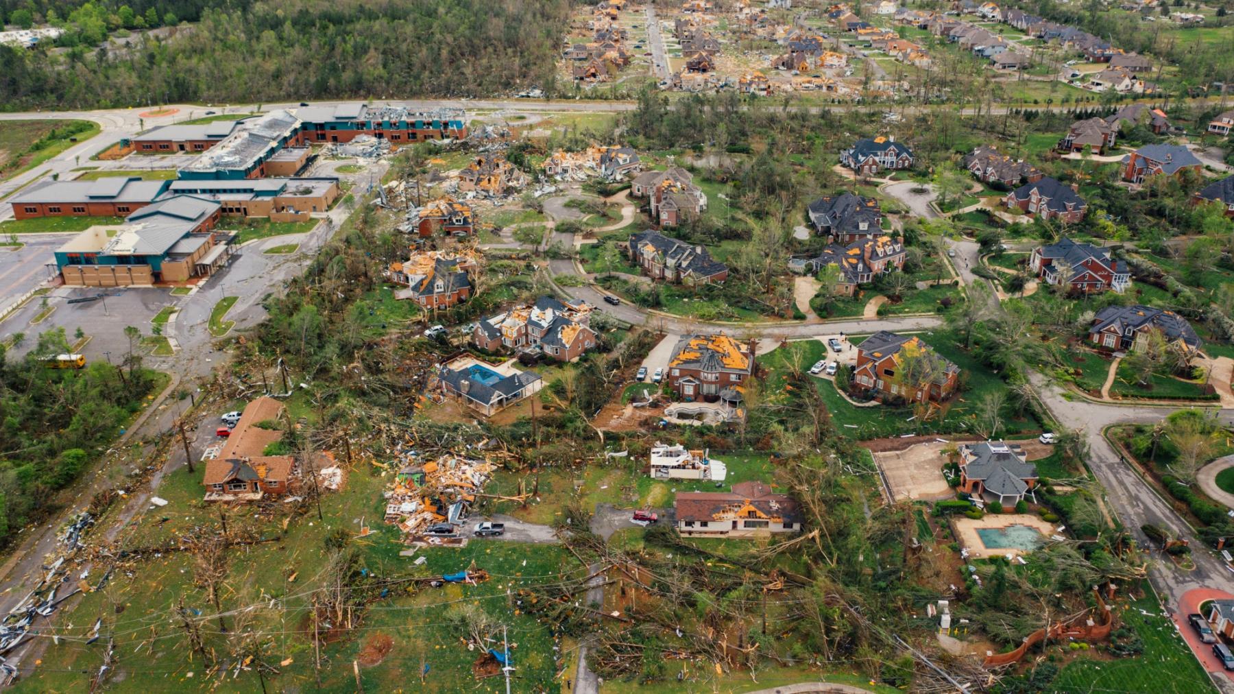
EF4 (Enhanced Fujita scale 4) — Devastating damage
Wind speed: 166–200 mph (75–89 m/s)
Potential damage: Tornado throw cars into the air and even move moving trains off railroad tracks; completely destroy barns and frame houses; and chops down large trees.
EF5 (Enhanced Fujita scale 5) — Incredible damage
Wind speed: >200 mph (>90 m/s)
Potential damage: Tornadoes move cars and other vehicles hundreds and thousands of yards (meters) from their parking places; completely sweep away frame houses and other small buildings, and leave serious structural damage on large buildings; tear out grass, corn, and other plants, and break and roll trees to the ground and move them to become a dangerous flying object in the air.

Enhanced Fujita Scale. Valerya Milovanova / Windy.app
Where to get tornado forecast?
In some way, you can find the tornado forecast on the Weather Map in the Windy.app. To do this, select the Wind or Wind gust layer (rather than Precipitation or Waves), although it is by default.
A tornado or a hurricane/typhoon can be defined as a small area on the map that stands out strongly due to its purple color in its center, indicating very high wind strength in the area. At the edges of the area, the colors change from purple through red and orange to yellow, green, and blue — that is, the farther from the center of the tornado or hurricane/typhoon, the lower the wind speed or wind gusts.
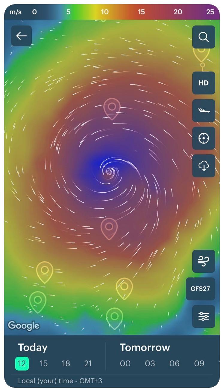
Typhoon Maysak 2020 in the Southeastern Asia the Windy.app for iOS
The colors of the map are commonly used to indicate wind speed. For convenience, you can change them to any other color you like.
Under the Units section in the app's Settings, you can also select the wind speed units that are used in your region: meters per second, miles per hour, or knots.
You can also try to track tornadoes and hurricanes/typhoons on the Windy.app website on a similar Live Wind Map clicking on the link of the same name in the main menu.
Text: Ivan Kuznetsov, an outdoor journalist, editor and writer from the Dolomites, Italy, and Karelia, Finland, with 10 years of professional experience. His favorite sports are hiking, cycling and sauna. Read his other articles
Cover photo: Extreme Tornado Tours
You will also find useful
How to read wind direction. Even if it sounds too simple
What are wind alerts and how to use them for your sport or outdoor activity
Latest News
Professional Weather App
Get a detailed online 10 day weather forecast, live worldwide wind map and local weather reports from the most accurate weather models.
Compare spot conditions, ask locals in the app chat, discover meteo lessons, and share your experience in our Windy.app Community.
Be sure with Windy.app.


