
The Saffir-Simpson Wind Scale — the key to understanding the power of hurricanes
Every year from early June to the end of November, a series of tropical cyclones occur in the Western Hemisphere. They are called "Hurricane Season". They come one after another from the Atlantic Ocean toward the coast of the United States and other countries, often reaching not only coastal but also continental areas.
As with other meteorological phenomena, different scales are used to determine hurricane strength, the most common of which is the Saffir-Simpson Hurricane Wind Scale (SSHWS). It has been familiar since childhood to anyone who lives on the South and East Coasts of the United States, but if you are only traveling to the region from another part of the world, you may be hearing about it for the first time.
In this article, we’ll tell what the Saffir-Simpson Hurricane Wind Scale is and how to read it so you know what to expect from cyclones.
What is Saffir-Simpson Hurricane Wind Scale?
The Saffir-Simpson Scale is a scale used to classify hurricanes — strong tropical cyclones in the Western Hemisphere. Knowing the category of a hurricane, help people to prepare for it, warn about it and minimize the damage from it.
The scale was invented in the United States in 1971 by two specialists: civil engineer Herbert Saffir and meteorologist Robert Simpson. It’s not hard to guess that the names of the scale are their last names. At the time the scale was created, the latter was also director of the US National Hurricane Center (NHC), the main hurricane forecasting and warning organization in the United States. Given its necessity and importance, the scale began to be used universally after two years.
The scale is only used to classify tropical cyclones, which occur in the Atlantic and North Pacific oceans. In the rest of the world other organizations use other scales, and hurricanes are called typhoons there. They can also occur in the seas — for example, Medicanes in the Mediterranean.
The full long name of the scale is often abbreviated for convenience: the Saffir-Simpson Hurricane Scale (SSHS), Saffir-Simpson Wind Scale (SSWS), or just the Saffir-Simpson Scale (SSS).
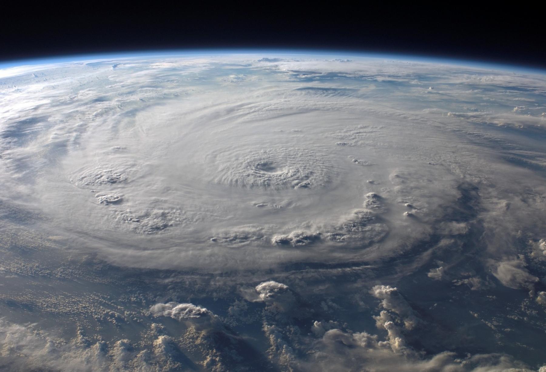
A huge tropical cyclone from space. Photo: Pexels
How to read Saffir-Simpson Hurricane Wind Scale?
The Saffir-Simpson Wind Scale is a simple scale that divides hurricanes into five categories. When we talk about the category of a hurricane, we talk about very strong wind, the basis of any storm. But hurricanes also bring heavy rain (downpoor), thunderstorms and lightning, and other kinds of extreme weather that the scale does not take into account.
For this reason, the scale is often criticized by some forecasters. The authors respond: "We don't want to make it difficult to understand."
So, to be considered a hurricane, a tropical cyclone must have a one-minute average maximum sustained wind of at least 33–42 m/s. Such winds are considered very dangerous, and stronger winds of 43–49 m/s are extremely dangerous. (Recall that winds are measured at 10 meters above sea level.) In this case, a tropical depression (less than 17 m/s, 38 mph, 62 km/h, 33 kn) or a tropical storm (18–32 m/s, 39–73 mph, 63–118 km/h, 34–63 kn), two types of weaker cyclones, are considered a Category 1 hurricane. Accordingly, the stronger it is, the higher its category — up to the strongest 5th. Beginning with the 3rd category, the hurricane is also assigned a "Major" type, which equals severe destruction.
The higher category also indicates the hurricane’s movements and its duration in time: the higher it is, the longer it lasts. "Minor hurricanes" of Categories 1–2 often end in just a few days or even bypass the coasts. Strong hurricanes of Categories 3–5 usually always reach the coasts and even continental areas and last about 5–7 days on average.
Hurricane strength is also often color-coded: blue for tropical depressions and storms, yellow and orange for hurricanes in Categories 1 through 3, and red for maximum Category 5 hurricanes.
According to History.com, "since 1924, there have been 35 documented hurricanes in the North Atlantic that reached this level. Five of them have hit the US at this maximum strength."
Below we list all five categories of hurricanes and the impact they have according to the primary source — the National Hurricane Center (NHC) of the US National Oceanic and Atmospheric Administration (NOAA). Data from the center also allows you to know not only the actual wind strength of a particular hurricane but also the devastating effects that it brings.

Saffir-Simpson Hurricane Wind Scale. Valerya Milovanova / Windy.app
Category 1 hurricane — Some damage
Category 1 hurricane is a hurricane with a wind speed of 33–42 m/s (74–95 mph, 119–153 km/h, 64–82 kn). Such a hurricanes damages the roof of frame houses and their structural elements, breaks tree branches and uproots entire trees with shallow roots, and damages power lines, causing power outages or blackouts over large areas for up to several days.
Examples of Category 1 hurricanes include Irene in 1999 and Katrina in 2005.
Category 2 hurricane — Extensive damage
Category 2 hurricane is a hurricane with a wind speed of 43–49 m/s (96–110 mph, 154–177 km/h, 83–95 kn). Such a hurricanes significantly damages frame buildings, uproots bigger trees over much larger areas and destroys power grids, which usually take days to weeks to repair in certain hard-to-reach areas.
An example of a Category 2 hurricane is Frances in 2004.
Category 3 hurricane (major) — Devastating damage
Category 3 hurricane is a hurricane with a wind speed of 50–58 m/s (111–129 mph, 178–208 km/h, 96–112 kn). These hurricanes tear off the roofs of frame houses and cause other structural damage to buildings, uproot trees and block roads, and damage or destroy power lines that can take weeks to repair.
Examples of Category 3 hurricanes include King in 1950, Betsy in 1965, Jeanne in 2004, Irma in 2017, and many unnamed hurricanes between 1909 and 1945.
Category 4 hurricane (major) — Catastrophic damage
Category 4 hurricane is a hurricane with a wind speed of 58–70 m/s (130–156 mph, 209–251 km/h, 113–136 kn). Such a hurricane severely damages frame houses, including the loss of much of the structure (roof, walls), rips out most trees with their roots in the area, and also brings down power poles, resulting in a total loss of electricity for several weeks to a month or more.
Examples of Category 4 hurricanes are Donna in 1960 and many unnamed hurricanes between 1888 and 1947.
Category 5 hurricane (major) — Catastrophic damage
A category 5 hurricane is a hurricane with a wind speed of 70 m/s or higher (157 mph or higher, 252 km/h or higher, 137 kn or higher). Such a hurricanes destroys large numbers of frame houses entirely, breaks and moves trees that isolate entire neighborhoods, and causes a complete lack of electricity and problems restoring it, making large areas uninhabitable for months or more.
Examples of Category 5 hurricanes include Andrew in 1992, Felix in 2007, Matthew is 2016, and Maria in 2017.
Where to get a hurricane forecast?
You can find the hurricane forecast on the Weather Map in the Windy.app. To do this, select the Wind or Wind gust layer (rather than Precipitation or Waves), although it is by default.
A hurricane or typhoon can be defined as a small area on the map that stands out strongly due to its purple color in its center, indicating very high wind strength in the area. At the edges of the area, the colors change from purple through red and orange to yellow, green, and blue — that is, the farther from the center of the hurricane/typhoon, the lower the wind speed or wind gusts.
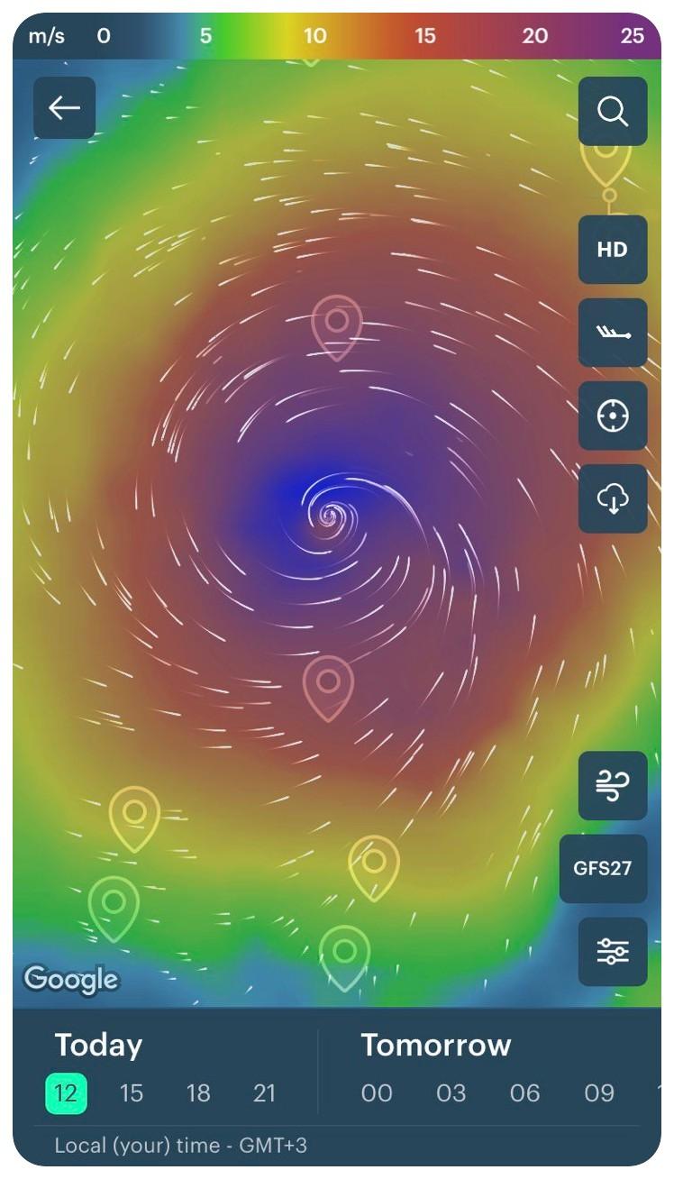
Typhoon Maysak 2020 in the Southeastern Asia the Windy.app for iOS
The colors of the map are commonly used to indicate wind speed. For convenience, you can change them to any other color you like.
Under the Units section in the app's Settings, you can also select the wind speed units that are used in your region: meters per second, miles per hour, or knots.
Hurricanes can also be tracked on the Windy.app website on a similar Live Wind Map in the section of the same name.
Text: Ivan Kuznetsov, an outdoor journalist, editor and writer from the Dolomites, Italy, and Karelia, Finland, with 10 years of professional experience. His favorite sports are hiking, cycling and sauna. Read his other articles
Cover photo: George Desipris / Pexels
You will also find useful
Learn to measure wind speed by the Beaufort scale
How to read wind barbs — wind speed and direction symbols
How to read wind direction. Even if it sounds too simple
Learn to read a tide table so you don't run aground (or end up in the sea)
Latest News
Professional Weather App
Get a detailed online 10 day weather forecast, live worldwide wind map and local weather reports from the most accurate weather models.
Compare spot conditions, ask locals in the app chat, discover meteo lessons, and share your experience in our Windy.app Community.
Be sure with Windy.app.


