
Weather models used in the Windy.app
On this page, we want to introduce you to our models, from which we get forecasts of atmospheric and ocean conditions.
Windy.app has two main types of forecast models: global - with forecasts at each point on the Earth and regional - with forecasts for particular areas or countries. Regional models pay close attention to the specific geographical features and surface conditions, but they offer a shorter-term forecast.
This is a comparison table and the main features of each model:
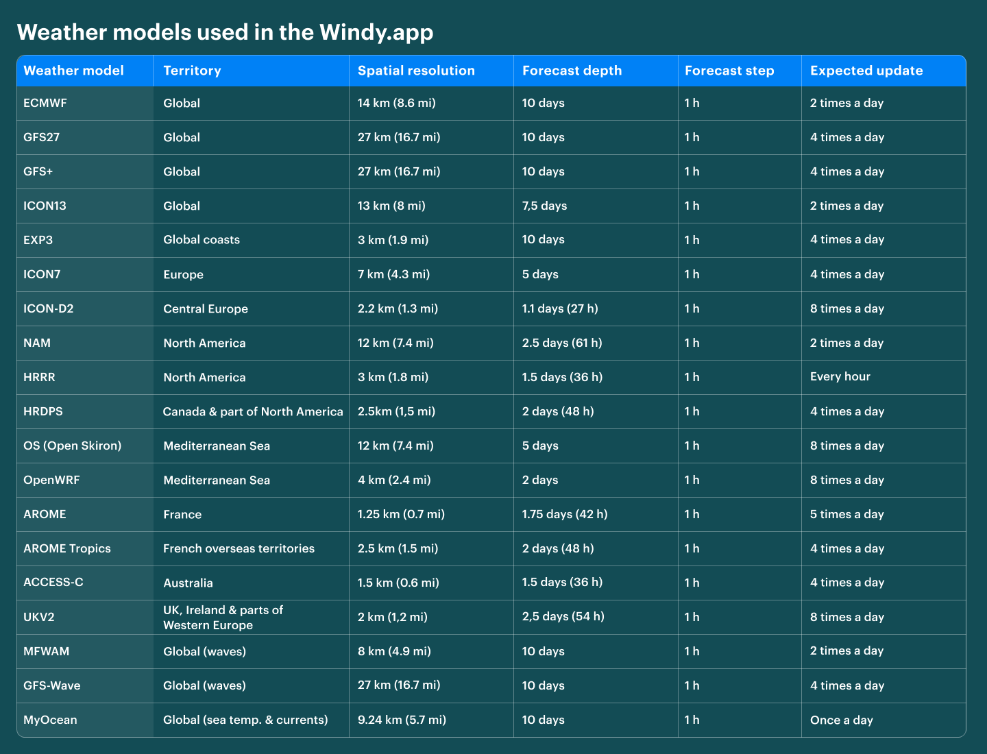
Weather models comparison table. Illustration: Valerya Milovanova / Windy.app
Let's understand what the data in the table means:
- The weather model is the source of the forecast. The model name is usually an acronym consisting of two or more words describing its origin, purpose, and other features, for example, ECMFW (European Centre for Medium-Range Weather Forecasts).
- Territory is an area of land and sea for which the weather model makes a forecast. A regional model may cover parts of the world and separate natural and geographical regions, such as Europe or the Mediterranean Sea.
- Spatial resolution is the distance between two points of the weather model grid. Bigger resolutions of 50 to 10 km in size are usually deployed in relatively flat terrains, while mountain ranges require the nodes to be a lot closer to each other, usually 5, 2, or 1 km.
- Forecast depth is the period or number of days (hours) for which the forecast is made. As a rule, the further the forecast is from the time of its calculation, the less accurate it is, since atmospheric conditions change very quickly
- Forecast step frequency There are two common step types: 1 h and 3 h. In the Windy.app, you can choose one or another because in models with 3 h step, we divide it up to 1 h.
- Expected update is a frequency of forecast updates during the day. For example, the forecast can be updated once a day, 2 times per day, and even every hour.
Now more about each model:
Global weather models
ECMWF

ECMWF weather model, London weather in the Windy.app for iOS
ECMWF (European Centre for Medium-Range Weather Forecasts) is a global weather model created and operated by the European Centre for Medium-Range Weather Forecasts with headquarters in Reading, Berkshire County, United Kingdom, since December 9–10, 1971. The main feature of the model is that it is one of the two leading global weather models on par with GFS from the United States. It is also considered the best for precipitation and cloudiness.
- Spatial resolution: 14 km (8.6 mi)
- Forecast depth: 10 days
- Forecast step frequency: 1 h
- Expected update: 2 times per day (every 12 h)
Learn more about ECMFW weather model in the Windy.app blog
GFS27
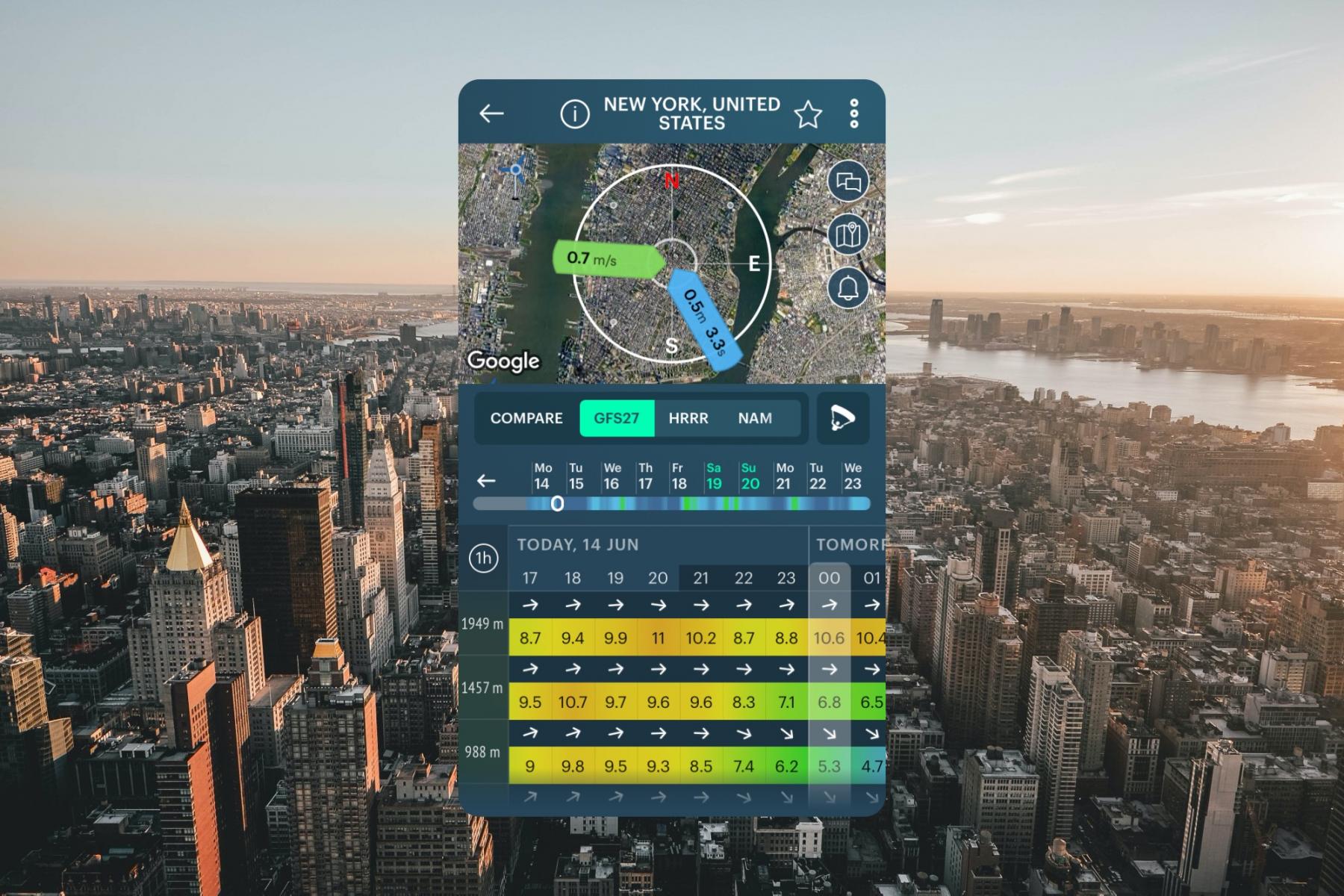
GFS27 weather model, New York weather in the Windy.app for iOS
GFS27 (Global Forecast System) is a global weather model by the United States' National Weather Service.
- Spatial resolution: 27 km
- Forecast depth: 10 days
- Forecast step frequency: 1 h for the first 5 days, after - 3 h (in Windy.app we divide it up to 1 h)
- Expected update: 4 times per day (every 6 h)
Learn more about GFS weather model in the Windy.app blog
GFS+
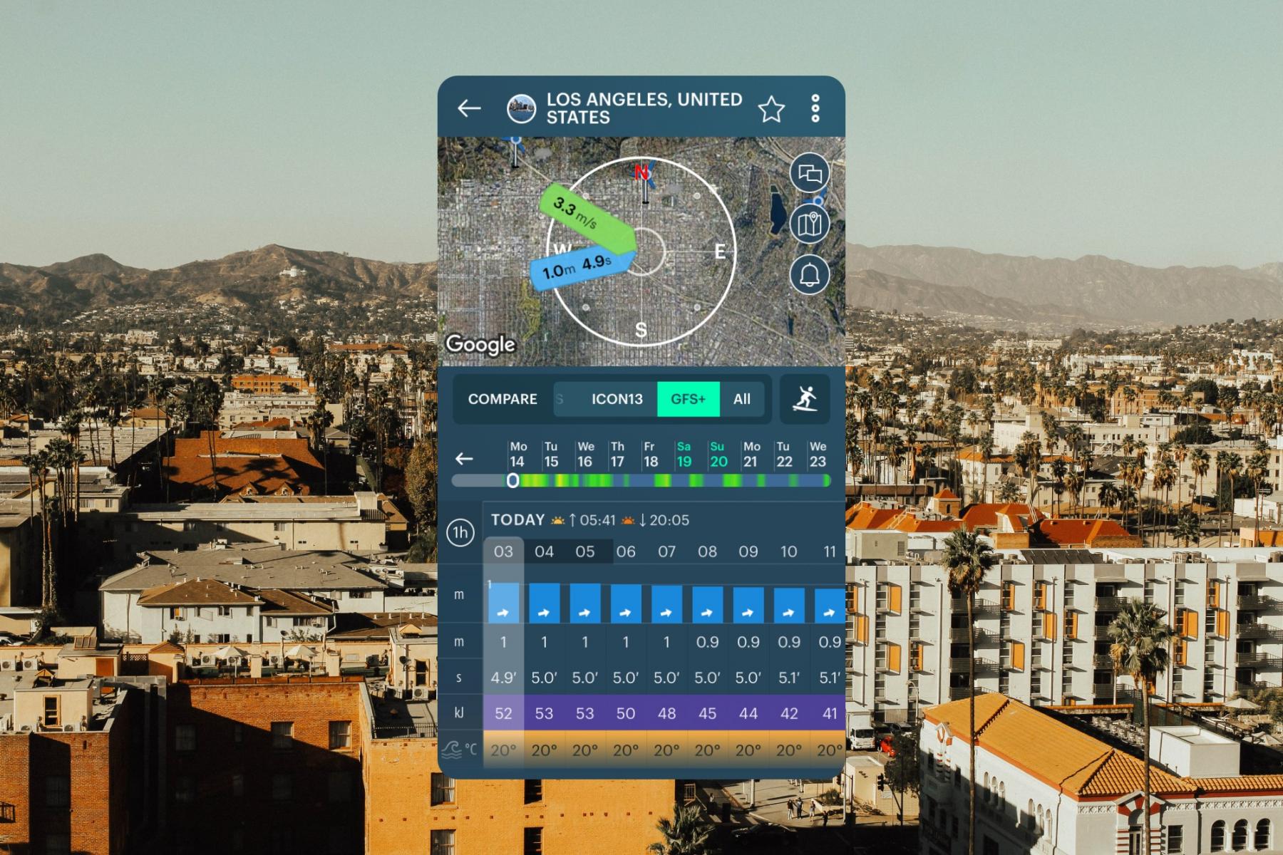
GFS+ weather model, Los Angeles weather in the Windy.app for iOS
GFS+ (Global Forecast System +) is Windy's modification of a global weather model by the United States' National Weather Service. While the GFS27 interpolates data for every dot within a 27 km x 27 km square, GFS+ always shows only the maximum result in each square.
- Spatial resolution: 27 km
- Forecast depth: 10 days
- Forecast step frequency: 1 h
- Expected update: 4 times per day (every 6 h)
Learn more about GFS weather model in the Windy.app blog
ICON13

ICON13 weather model, Rio de Janeiro weather in the Windy.app for iOS
ICON13 (Icosahedral Nonhydrostatic) is a global weather model by the Deutscher Wetterdienst (German National Meteorological Service).
- Spatial resolution: 13 km
- Forecast depth: 7.5 days
- Forecast step frequency: 1 h
- Expected update: 2 times per day (every 12 h)
Learn more about ICON weather model in the Windy.app blog
EXP-3 - AI-powered coastal wind forecast
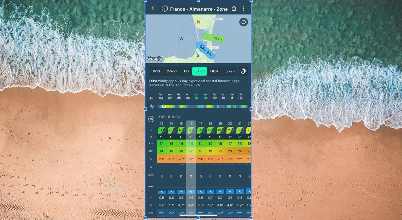
EXP-3 is a unique, high-resolution wind forecast model developed by Windy.app. Unlike traditional low-resolution global forecasts, EXP3 uses AI to provide detailed, terrain-aware predictions of wind flow along coastlines.
- Spatial resolution 3 km
- Forecast depth: 10 days
- Forecast step frequency: 1 hour
- Expected update: 4 times a day
Regional weather models
ICON7 — Europe

ICON7 weather model, Munich weather in the Windy.app for iOS
ICON7 (Icosahedral Nonhydrostatic) is a regional Europe weather model by the Deutscher Wetterdienst (German National Meteorological Service).
- Spatial resolution: 7 km
- Forecast depth: 5 days
- Forecast step frequency: 1 h
- Expected update: 4 times per day (every 6 h)
Learn more about ICON weather model in the Windy.app blog
ICON-D2 — Central Europe

ICON-D2 weather model, Vienna weather in the Windy.app for iOS. Jacek Dylag / Unsplash
ICON-D2 (Icosahedral Nonhydrostatic) is a regional hyper-local weather model for Central Europe by the DWD (Deutscher Wetterdienst), German National Meteorological Service. Thanks to its high resolution, it takes into account the terrain and also predicts severe weather better.
- Spatial resolution: 2.2 km (1.3 mi)
- Forecast depth: 2 days (48 h)
- Forecast step frequency: 1 h
- Expected update: 8 times per day (every 3 h)
Learn more about ICON weather model in the Windy.app blog
NAM — North America
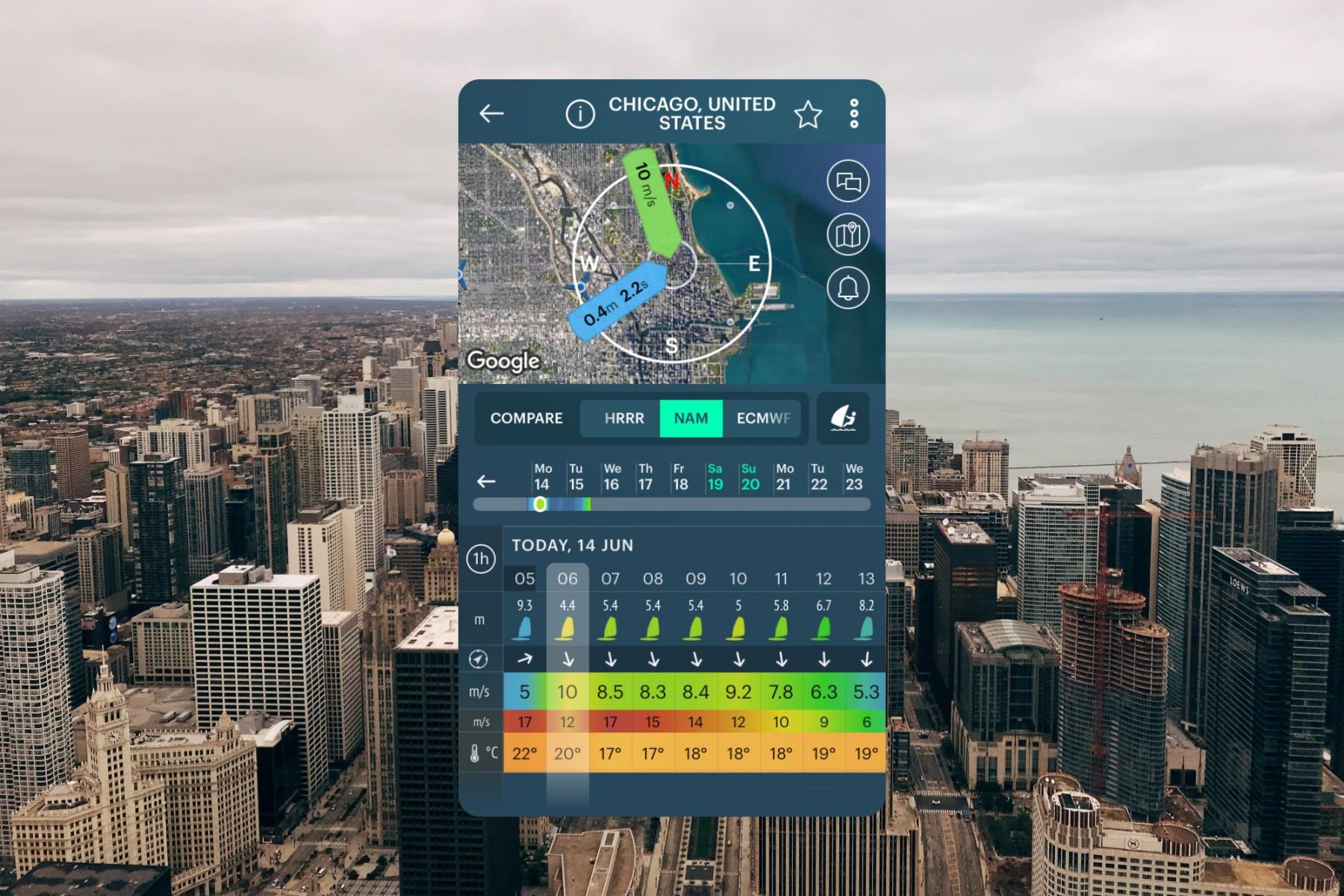
NAM weather model, Chicago weather in the Windy.app for iOS
NAM (North American Mesoscale Forecast System) is a regional North American weather model by the National Centers for Environmental Prediction (NCEP) of the National Oceanic and Atmospheric Administration of the US (NOAA).
- Spatial resolution: 12 km
- Forecast depth: 2,5 days
- Forecast step frequency: 1 h
- Expected update: 2 times per day (every 12 h)
Learn more about NAM weather model in the Windy.app blog
HRRR — North America
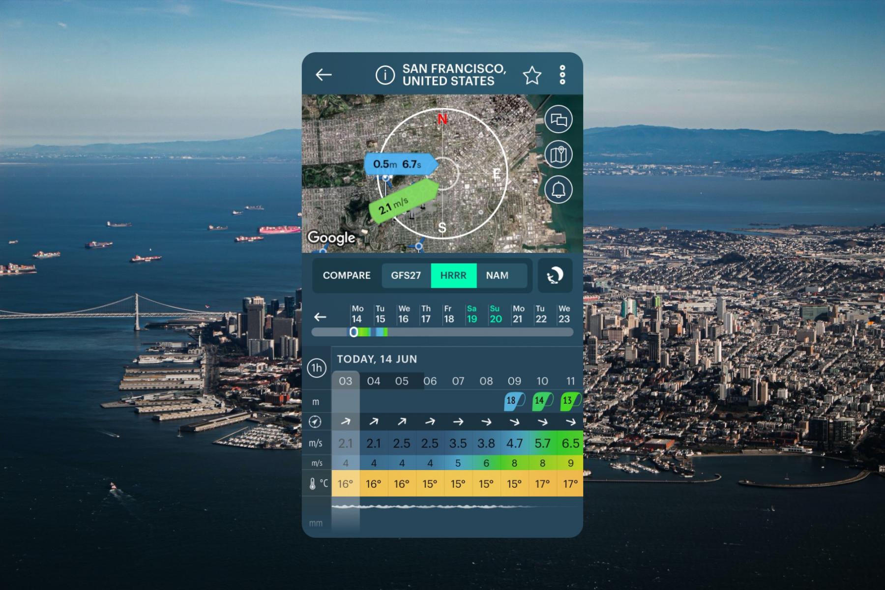
HRRR weather model, San Francisco weather in the Windy.app for iOS
HRRR (High Resolution Rapid Refresh) is a regional North American weather model by the National Oceanic and Atmospheric Administration of the US (NOAA). It provides a great forecast for the continental US, Canada, and Mexico based on radar data — the unique advantage of HRRR. It is assimilated every 15 min over a 1 h period. It gives short-range weather forecasts with pretty good accuracy.
- Spatial resolution: 3 km
- Forecast depth: 1.5 days (36 h)
- Forecast step frequency: 1 h
- Expected update: 24 times per day (every hour)
Learn more about HRRR weather forecast model in the Windy.app blog
HRDPS — Canada and part of North America
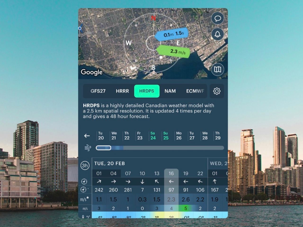
HRDPS is a highly detailed Canadian weather model. The high resolution allows the model to take into account complex terrain and topography. It can reproduce breezes and local circulations, providing accurate mean wind speed, direction, gusts, air temperature, precipitation, cloudiness, atmospheric pressure at sea level, and relative humidity.
- Spatial resolution: 2,5 km
- Forecast depth: 2 days (48 h)
- Forecast step frequency: 1 h
- Expected update: 4 times per day (every 6 hours)
OS (OpenSkiron) — Mediterranean

Open Skiron weather model, Athens weather in the Windy.app for iOS
OS (Open Skiron) is a regional Mediterranean weather model by the University of Athens.
- Spatial resolution: 12 km
- Forecast depth: 5 days
- Forecast step frequency: 3 h (in the Windy.app, we divide it up to 1 h)
- Expected update: 8 times per day (every 3 h)
Learn more about Open Skiron weather model in the Windy.app blog
OpenWRF — Mediterranean

OpenWRF weather model, Barcelona weather in the Windy.app for iOS
The Open WRF (Open Weather Research and Forecasting) is a regional Mediterranean weather model by the University of Athens and a group of enthusiasts based on the WRF technology.
- Spatial resolution: 4 km
- Forecast depth: 2 days
- Forecast step frequency: 1 h
- Expected update: 8 times per day (every 3 h)
Learn more about OpenWRF weather model in the Windy.app blog
AROME — France and the surrounding territories

AROME weather model, Paris weather in the Windy.app for iOS
AROME is a highly detailed regional weather model by the Meteo France (French National Meteorological Service). It is calculated for France and the surrounding territories and takes into account terrain and local processes.
- Spatial resolution: 1.25 km
- Forecast depth: 1,7 days
- Forecast step frequency: 1 h
- Expected update: 5 times per day (every 5 h)
Learn more about AROME weather model in the Windy.app blog
AROME Tropics — French overseas territories
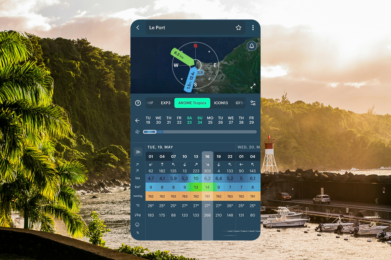
AROME Tropics is a version of the AROME model designed specifically for the French overseas territories. It originally consists of five separate regional segments that we combined together: Réunion–Mayotte, French Guiana, the Antilles, New Caledonia, and French Polynesia.
The high resolution of this model significantly improves forecast accuracy in coastal areas.
-
-
- Spatial resolution: 2.5 km
- Forecast depth: 2 days (48 hours)
- Forecast step frequency: 1 h
- Expected update: 4 times per day (every 6 h)
-
ACCESS-C — Australia
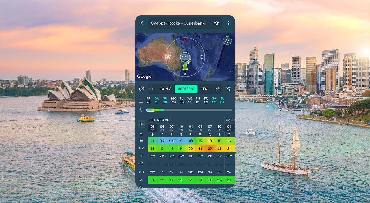
ACCESS-C (Australian Community Climate and Earth-System Simulator – Convective) is a regional Australian weather model developed by the Bureau of Meteorology. It covers Australia’s capital city regions and their surroundings. The model excels at forecasting wind, precipitation, and extreme weather events and is especially well known for its high accuracy in coastal areas.
- Spatial resolution: 1.5 km (0.6 mi)
- Forecast depth: 1.5 days (36 hours)
- Forecast step frequency: 1 h
- Expected update: 4 times a day (every 6 h)
UKV2 — the UK, Ireland, and the surrounding territories

Met Office weather model for the UK, Ireland, and parts of Western Europe. It’s detailed enough to show breezes and local circulations in the wind forecast and it’s perfect for short-term planning in terms of accuracy.
- Spatial resolution: 2 km
- Forecast depth: 2,5 days (54 hours)
- Forecast step frequency: 1 h
- Expected update: 8 times per day (every 3 h)
Special global weather models
MFWAM (waves/swell)
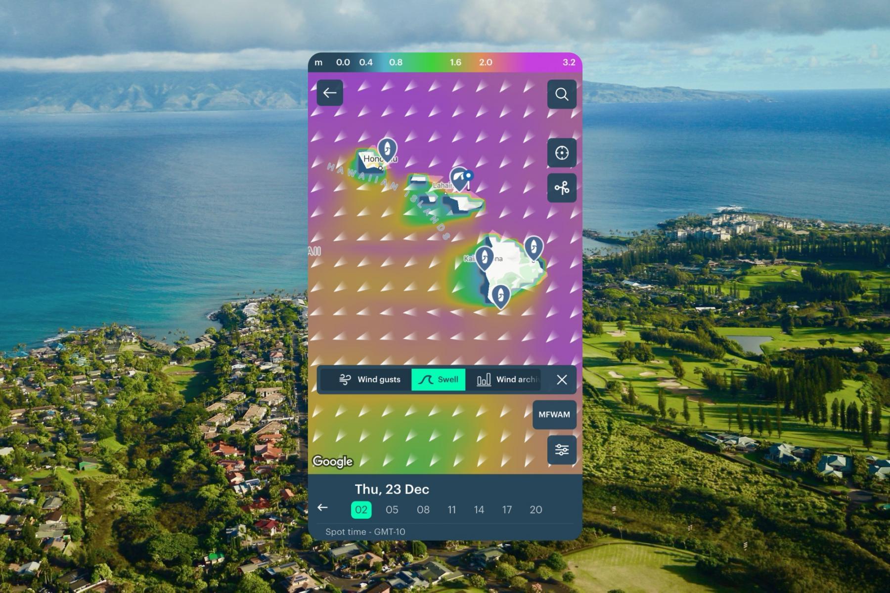
MFWAM weather model, Maui, Hawaii, USA, weather in the Windy.app for iOS
MFWAM (Météo-France WAve Model) is a third-generation numerical weather forecast model provided by the Météo-France, the French Main National Meteorological Service, which uses it as the basis of its global wave system.
- Spatial resolution: 8 km
- Forecast depth: 10 days (240 h)
- Forecast step frequency: 3 h (in the Windy.app, we divide it up to 1 h)
- Expected update: 2 times per day (every 12 h)
Learn more about MFWAM weather model in the Windy.app blog
GFS-Wave

- Spatial resolution: 27 km
- Forecast depth: 10 days (240 h)
- Forecast step frequency: 1 h
- Expected update: 4 times per day (every 4 h)
My Ocean (currents and sea temperature)

My Ocean weather model, Palermo, Sicily, Italy, weather in the Windy.app for iOS
The MyOcean weather model is the world's main model with currents, tides and sea temperature forecasts. These are typically updated once a day and cover oceans, seas and coastal areas but not rivers and lakes, even big ones. The model is part of the Copernicus Marine Service (CMS), which, in turn, is run by the Copernicus Programme, which is the European Union's Earth Observation Programme, looking at our planet and its environment for the ultimate benefit of all European and global citizens.
- Spatial resolution: 9.24 km
- Forecast depth: 10 days
- Forecast step frequency: 1 h
- Expected update: once a day (every 24 hours)
Learn more about MyOcean weather model in the Windy.app blog
Get the list of all world's major weather models, including the ones, that are not used in the Windy.app such as UM by UK Met Office, GEM by Canadian Meteorological Center, ALADIN by Météo-France, and others.
Updated on December 21, 2025
Text: Windy.app team
Cover photo: Markusspiske / Unsplash
Latest News
Professional Weather App
Get a detailed online 10 day weather forecast, live worldwide wind map and local weather reports from the most accurate weather models.
Compare spot conditions, ask locals in the app chat, discover meteo lessons, and share your experience in our Windy.app Community.
Be sure with Windy.app.


