What is MyOcean weather model and how it works
The MyOcean weather model is the world's main forecast model that provide currents, tides and sea temperature forecasts. If you're looking at the forecast for surfing, sailing, diving, and other water sports and outdoors activities right now, it probably comes from this model.
In this post, you will learn about MyOcean weather model, its working principles and the main features, as well as where to find the weather forecast by this model.
What is MyOcean weather model?
The MyOcean weather model is the world's main model with currents, tides and sea temperature forecasts. These are typically updated once a day and cover oceans, seas and coastal areas but not rivers and lakes, even big ones.
The model is part of the Copernicus Marine Service (CMS), which provides open and systematic reference information on the blue (physical), white (sea ice), and green (biogeochemical) ocean state, variability and dynamics across the global ocean and European regional seas.
The CMS, in turn, is run by the Copernicus Programme, which is the European Union's Earth Observation Programme, looking at our planet and its environment for the ultimate benefit of all European and global citizens.
The program is coordinated and managed for the European Commission by the European Union Agency for the Space Programme in partnership with the European Space Agency (ESA), the EU Member States.
MyOcean is also composed of a consortium of 60 partners from across Europe and is structured around a core team of Marine Core Service operators, and connected to key R&D players and experts. These include UK Met Office, Danmarks Meteorologiske Institut, Météo-France and others.
The official websites of MyOcean weather model and Copernicus Marine Service are: Copernicus.eu/en/myocean and Marine.copernicus.eu.

Palermo, Sicily, Italy weather forecast from MyOcean weather model. Photo: Henrique Ferreira / Unsplash
What are the main features of MyOcean weather forecast model and how it works?
The model has a resolution of 9.24 km (5.7 mi). The resolution is the distance between two points of the weather model grid. Bigger resolutions of 50 to 10 km in size are usually deployed in relatively flat terrains, while mountain ranges require the nodes to be a lot closer to each other, usually 5, 2, or 1 km.
The forecast depth is 10 days (240 h). The depth of the weather forecast is the number of hours or days for which the forecast is made. As a rule, the lower the depth, the more accurate the forecast.
The forecast step is 1 hour. The forecast step is for how long you can see a forecast in the application or on a website. There are two main step types: 1 h and 3 h.
The updates frequency is once a day (every 24 h) for both regions. The update frequency of the forecast is the regular time interval after which new forecast data is received from the supercomputers. There are other models like HRRR with 24 times a day updates, but in general, the frequency of the updates of weather models is 1, 2, or rather 4 times a day.
Let's sum up the main features of MyOcean model:
- Resolution (grid): 9.24 km (5.7 mi)
- Depth (period): 10 days
- Step: 1 h
- Updates: once a day (every 24 hours)
Where to get the weather forecast from the MyOcean model in the Windy.app?
The MyOCean is the one of the main models in the app among 10+ others. To get a weather forecast from it, do the following easy steps:
1. Open your favorite or the nearest spot to your current location, for example, Marina di Palermo, Sicily, Italy, in the app from the Home Screen or the Weather Map. To see the nearest spots, allow the app to see your location in Settings.

Home Screen in the Windy.app for iOS
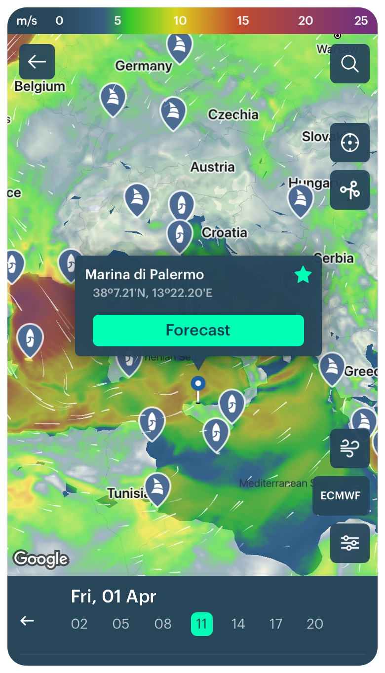
Marina di Palermo sailing spot on the Weather Map in the Windy.app for iOS
2. Click on the spot and go to the Spot screen (page) to get the detailed forecast:
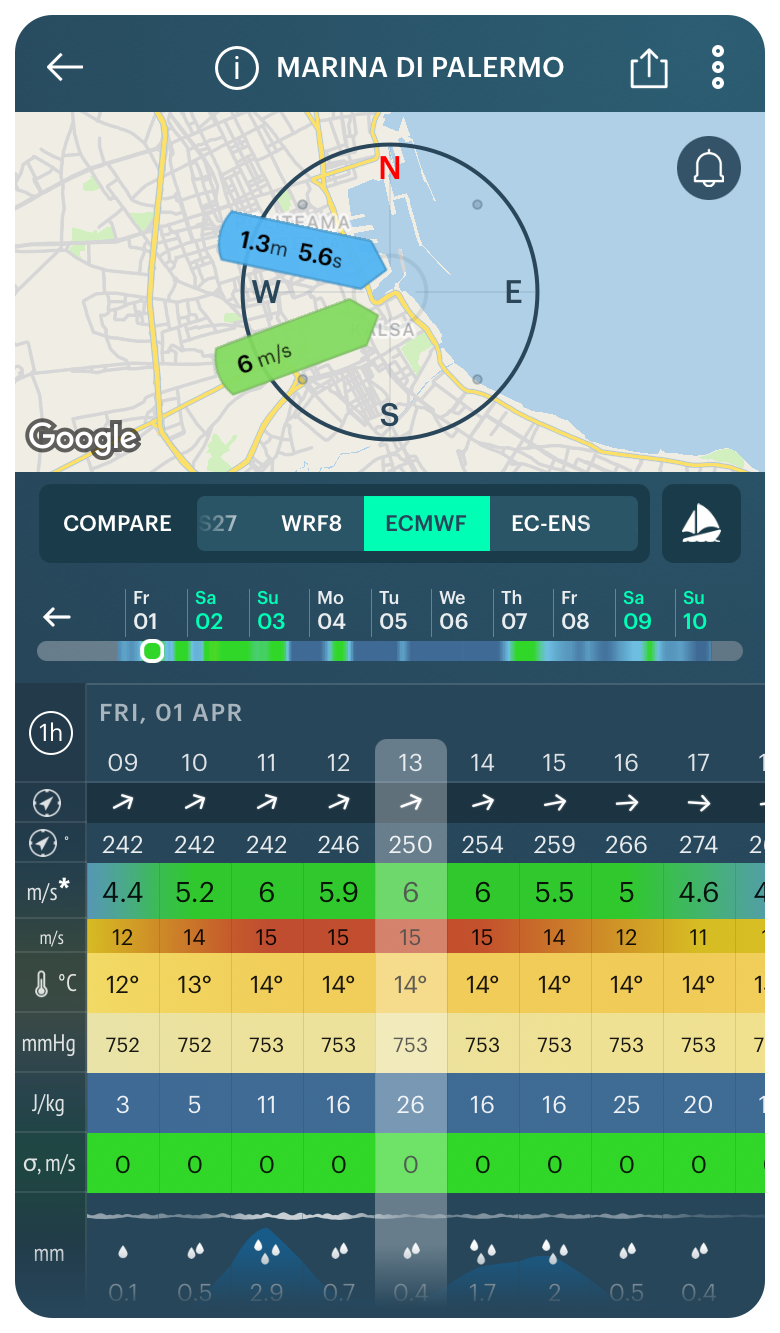
Marina di Palermo weather forecast in the Windy.app for iOS
3. Choose any weather forecast model in the slider to get the general weather forecast, for example, the global weather model ECMWF from the US Natonal Weather Service. Then, choose Sail Weather Profile by an icon right to the weather models slider to get sea forecast.
Read the forecast in the forecast table. In the Windy.app, you can get the following weather parameters from the MyOcean weather model:
- Currens direction
- Currents speed
(Remember that on the screen, there are additional weather parameters, which comes to form the different models.)

Currentds forecast from MyOCean weather model in the Windy.app for iOS
You can also have two other important water parameters: sea temperature and tides represented by a special chart. The first could be find in the Surf Weather Profile. To get this forecast, change the weather profile from Sail to Surf before. The second is in both profiles.
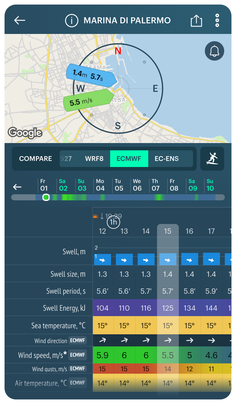
Sea temperature and tides forecast in the Windy.app for iOS
Read about other weather forecast models used in the Windy.app, as well as the complete guide to all major weather models in the world.
- ECMWF
- ECMWF-ENS (Ensembles)
- GFS
- ICON
- NAM
- HRRR
- Open Skiron
- OpenWRF
- AROME
- Windy.app's WRF8
- MFWAM
- MYOCEAN
Text: Ivan Kuznetsov, an outdoor journalist, editor and writer from the Dolomites, Italy, and Karelia, Finland, with 10 years of professional experience. His favorite sports are hiking, cycling and sauna. Read his other articles
Cover photo: Victoria Palacios / Unsplash
You will also find useful
What is a weather forecast and how it works
What does a 10 day and other weather forecast durations mean
Latest News
Professional Weather App
Get a detailed online 10 day weather forecast, live worldwide wind map and local weather reports from the most accurate weather models.
Compare spot conditions, ask locals in the app chat, discover meteo lessons, and share your experience in our Windy.app Community.
Be sure with Windy.app.


