
What is MFWAM weather model and how it works
The MFWAM weather model is the world's main weather forecast model for the global ocean sea surface waves. If you're looking at the forecast for surfing and other water activities right now, it probably comes from this model.
In this post, you will learn about the MFWAM weather model, its working principles, and the main features, as well as where to find the weather forecast by this model.
What is MFWAM weather model?
MFWAM (Météo-France WAve Model) is a third-generation numerical weather forecast model provided by the Météo-France, the French main national meteorological service, with headquarters in Paris, France, which uses it as the basis of its global wave system.
The operational model is driven by 6-hourly analysis and 3-hourly forecasted winds from the IFS-ECMWF atmospheric system.
From this model, you can get swell forecasts for surfing and other water sports and outdoor activities, including such wave parameters as significant height, period, direction, Stokes drift, wind wave, primary and secondary swell, and others.
The official website of the model is Météo-France.com.

MFWAM weather model, Maui, Hawaiian Islands, United States, weather in the Windy.app for iOS. Photo: Andrew Bain / Unsplash
What are the main features of MFWAM weather forecast model and how it works?
The MFWAM model has a resolution of 1/12 degrees or roughly 8 km (4.9 mi). The resolution is the distance between two points of the weather model grid. Bigger resolutions of 50 to 10 km in size are usually deployed in relatively flat terrains, while mountain ranges require the nodes to be a lot closer to each other, usually 5, 2, or 1 km.
The forecast depth of MFWAM weather model is 10 days or 240 hours. The depth of the weather forecast is the number of hours or days for which the forecast is made. As a rule, the lower the depth, the more accurate the forecast.
The MFWAM weather model updates frequency is twice a day. The update frequency of the forecast is the regular time interval after which new forecast data is received from the supercomputers. There are other models like HRRR with 24 times a day updates, but in general, the frequency of the updates of weather models is 2, or rather 4 times a day.
Let's sum up the main features of MFWAM model:
- Spatial resolution: 1/12 degree of roughly 8 km (4.9 mi)
- Forecast depth: 10 days (240 h)
- Forecast step: 1 h
- Forecast update frequency: twice a day (every 12 h)
Where to get the weather forecast from the MFWAM model?
The MFWAM model is one of the 13+ weather models used in the Windy.app. From all the parameters of this model, we use combined swell+wind waves forecast and primary swell period. In the app, the model has the same 8 km (4.9 mi) resolution. Waves forecast in the Windy.app app updates twice a day (around 00:00 UTC and 12:00 UTC). To get a weather forecast:
1. Open your favorite or the nearest spot to your current location, for example, Maui, Hawaiian Islands, United States, in the app from the Home Screen or the Weather Map. To see the nearest spots, allow the app to see your location in Settings.
Home Screen in the Windy.app for iOS

Maui surfing spot on the Weather Map in the Windy.app for iOS
2. On the Weather Map, select the Swell layer to see the swell forecast for this particular location, the region and the whole world. Learn about how to read a Swell Map in a separate post in the News.
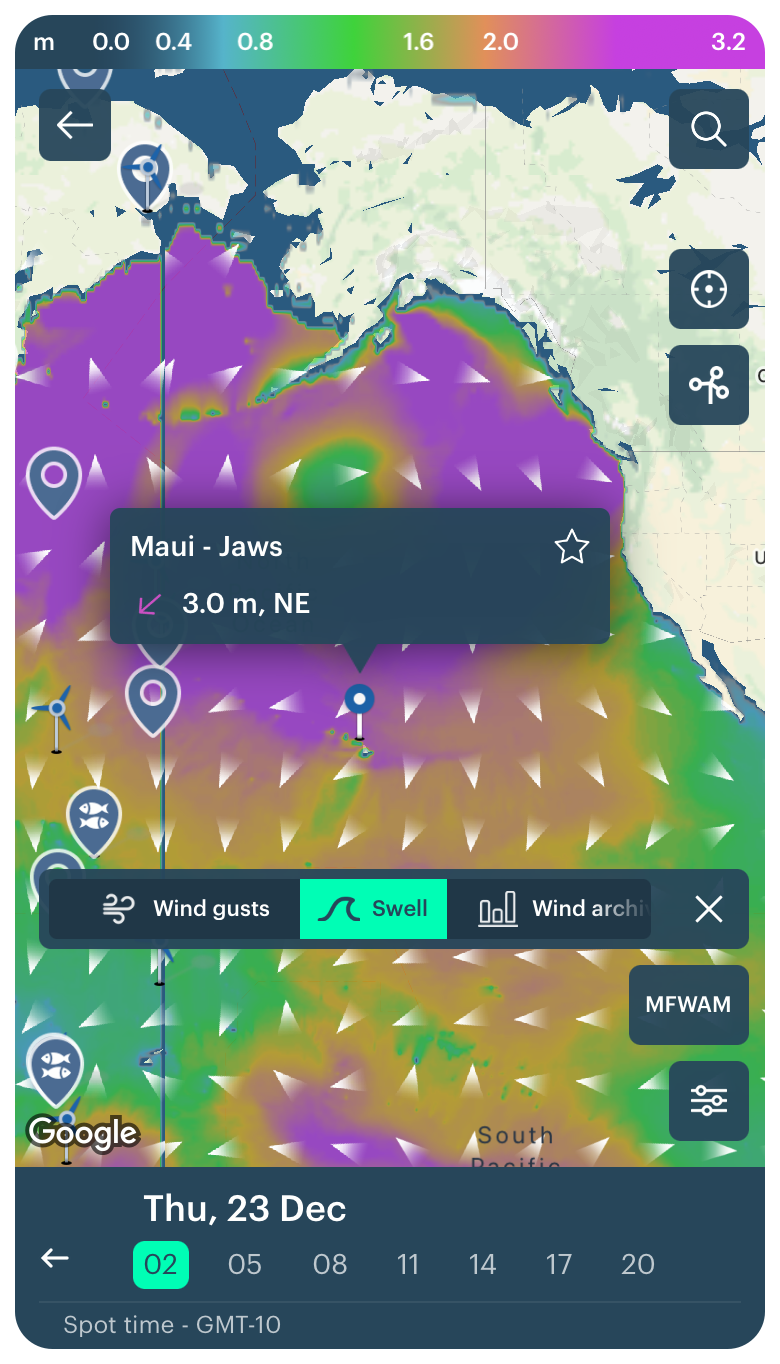
Maui surfing spot swell map on the Weather Map in the Windy.app for iOS
3. Then, click on the spot and go to the Spot screen (page) to get the detailed swell and weatherf forecast.

Maui swell forecast from the MFWAM weather model in the Windy.app for iOS
3. Choose any weather forecast model in the slider to get the general weather forecast, for example, the global weather model ECMWF from the US Natonal Weather Service. Then, choose Surf weather profile by an icon right to the weather models slider to get swell forecast. The swell forecast on the spot screen is still provided by the same MFWAM model.
Read the swell forecast in the forecast table. In the Windy.app, you can get the following weather parameters from the MFWAM weather model:
- Swell direction
- Swell size (or swell heigh)
- Swell period
- Swell energy
Learn how to read a surf forecast to get the best surfing experience.
(On the screen, there are additional weather parameters, which come to form the different models.)
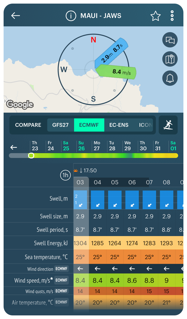
Swell forecast from the MFWAM weather model and weather forecast from the different weather models in the Windy.app for iOS
You can also have two other important water parameters for surfing: sea temperature and tides represented by a special chart, in the Surf profile.

Sea temperature and tides forecast in the Windy.app for iOS
Read about other weather forecast models used in the Windy.app:
Read the complete guide to all major weather models in the world.
Text: Ivan Kuznetsov, an outdoor journalist, editor and writer from the Dolomites, Italy, and Karelia, Finland, with 10 years of professional experience. His favorite sports are hiking, cycling and sauna. Read his other articles
Cover photo: Jeremy Bishop / Unsplash
You will also find useful
How to learn surfing. A brief instructions
How to choose the right wetsuit
Latest News
Professional Weather App
Get a detailed online 10 day weather forecast, live worldwide wind map and local weather reports from the most accurate weather models.
Compare spot conditions, ask locals in the app chat, discover meteo lessons, and share your experience in our Windy.app Community.
Be sure with Windy.app.


