Weather forecast
10 day weather forecast for Zion National Park, United States contains useful information about local wind speed, direction, and gusts, temperature, cloud coverage and precipitation based on the global GFS weathel model. All data updates four times a day with a forecast step of 3 hours. There is also a real-time wind forecast for Zion National Park from the nearest weather station to the spot, and a live Wind Map of the region and the world.
Get the weather forecast for all 63 US national parks on this website and in the Windy.app with more weather for hiking in the US, and other sports.
Weather, climate and seasons
Zion National Park weather is characterized by a cold semi-arid climate with a limited amount of precipitation throughout the year. It is usually very hot in summer and quite cold in winter. Temperature variations can be up to 30 °F, depending on altitude, time of day, and season.
Winter
Winter in the Zion National Park lasts from December through March. This time is considered the low season.
- Temperatures range from 30 and 50 °F but often drop to freezing at night.
- There are many snowfalls during the winter. Some popular roads — such as Kolob Canyons Road and Kolob Terrace Road — may be closed due to snow. Some trails, especially in the shade, may be covered by ice. The average snow precipitation is around 1 inch a month, or 7 days. At low altitudes, snow usually melts immediately. On the tops of the mountains the snow stays for a long time. This makes the bright red mountains look especially beautiful. In winter, it rains also the most throughout the year: Up to half of the annual precipitation. Average rain precipitation in winter is between 1.63 and 1.98 inches a month, or 21 days for the whole season of three months. Learn how to enjoy hiking in the rain from this article.
Spring
Spring in Zion National Park comes in late February or beginning of March. The first visitors arrive at the park for hiking and other activities.
- Spring temperatures are comfortable between 40 and 60 °F.
- The snow is starting to melt on the park's mountains, as well, but high elevation areas may still be closed because of the snow, if there was a lot of snow during the winter. The meltwater is good for wildflowers, which bloom here around April. The rivers in the park, including the Virgin River, fill with water and overflow heavily. Spring is the most dangerous time to hike in the Zion because of the flash floods. Some areas with lots of water, such as Narrows, are closed to hikers in spring. Average precipitation in spring is between 0.67 and 2.04 inches a month, or 19 days for the whole season of three months.
Summer
Summer in Zion National Park begins in May-June. This is the most popular season with millions of people in the park.
- Average high air temperatures in summer are between 60 and 100 °F. It could be above 100 °F in the middle of the day during all three summer months. In summer, the weather in the park is very hot, especially if you go down into the Zion Canyon. To avoid heatstroke the Heat Index may be useful to you. But it gets cooler as the altitude rises. Ideal places for summer outdoor activities are Kolob Canyons, Kolob Terrace, and Narrows where it is not so hot as in Zion Canyon. Be sure to bring more water. Use long sleeves clothes, a hat and other sun protection.
- From July to mid-September, the monsoon season comes. During this time, the weather can change frequently: sun in the morning, and in the afternoon thunderstorms with rain and floods. Average precipitation is between 0.31 and 1.45 inches a month, or 15 days.
Fall
Fall in Zion National Park is September, October and November. There are fewer people in the park in fall than in summer, but still more than in spring and winter. Autumn is an ideal time for outdoor activities. It is also a very beautiful time in the park as the poplars and aspens turn yellow. The park is good for photography.
- This time of year the temperature is usually between 60 and 90 °F. Then, it can already be 10 degrees colder in October than in September. Bring warm clothes with you. In November, the park's trees are usually already bare and it gets even colder, with the first frosts at night.
- Rains are also quite possible in fall. The average precipitation in fall is between 1.04 and 1.42 inches a month, or the same 15 days the whole season of three months.
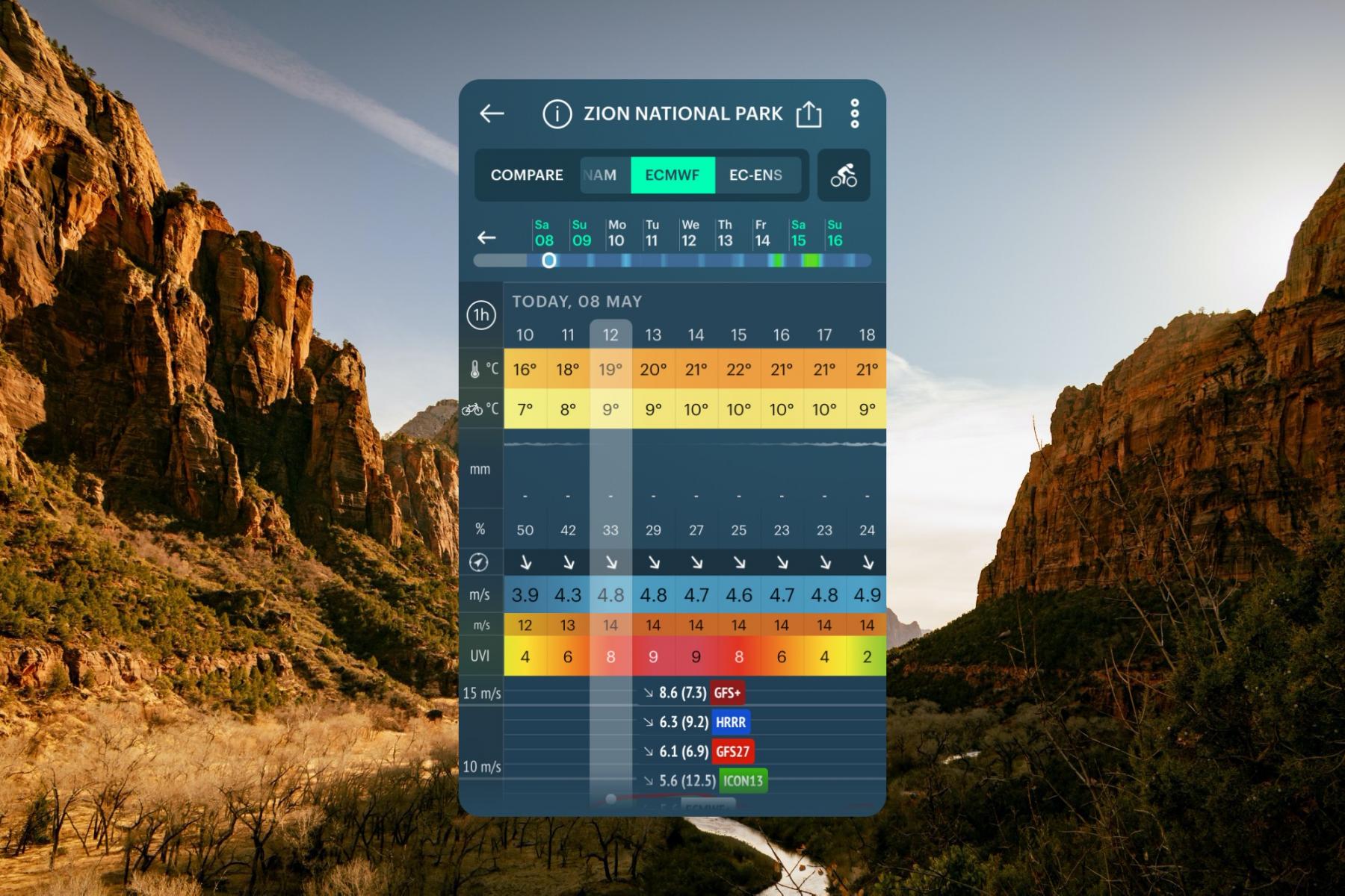
Zion National Park weather forecast in the Windy.app Bike Weather Profile showing many weather parameters including very high UV Index 9 on May 8, 2021 between 13 and 15 pm. Photo: Mani-bhargava / Unsplash
Best time to travel
The best time to travel to Zion National Park is a warm season: spring, summer, and fall. The best months to visit are April through October, except maybe the hottest time in July and August. During the summer there are also shuttle buses that will take you to different parts of the park. But at the same time, there will be more people.
Choosing when to visit Zion National Park, consider the time when spring turns to summer and summer to fall, but not early spring, when rivers are flooding and you can't go down into the canyon. Fall is better for outdoor activities than the hot summer or spring with rains. In winter it is worth coming to Zion to see its mountains in the snow and to enjoy recreation without the crowds.
Spot overview and travel information
Zion National Park is one of the most popular parks in the United States in the last few years, which is located in the heart of Utah. The nearest towns are Springdale, Saint George, Orderville, Rockville, Cedar City. The nearest airports are Las Vegas McCarran International Airport in Las Vegas, Nevada (170 mi), and Salt Lake City International Airport in Salt Lake City, Utah (300 mi).
The park's main feature is the Zion Canyon, composed of red and bronze-colored mountains. The canyon was formed by the Virginia River in the Navajo Sandstone rocks. Its total length is 24 kilometers (15 miles) and its depth is 800 meters (2,640 ft).
The best hiking trail in the park is a hike to Observation Point (4 mi). You'll have to gain 2,000 feet of elevation to get to the point, but the effort is worth it: The views of Zion Canyon from there are spectacular, and it's less crowded than the more popular Angel's Landing viewpoint. In addition to hiking and backpacking, in the park you can do climbing, canyoneering, kayaking, horseback riding, wildlife watching, camping and other sports and outdoor activiries.
There are two visitor centers in the park: Zion Canyon Visitor Center (1 Zion Park Blvd, Springdale, UT, 84767, USA, phone: 1-435-772-3256) and Kolob Canyons Visitor Center (3752 E Kolob Canyon Rd, New Harmony, UT, 84757, USA, phone: (435) 586-9548). The park's tickets cost $20 per person, $35 per vehicle, $30 per motorcycle. Park's annual pass is $70.
- Date of origin: November 19, 1919 (102 years)
- Area: 1.635.19 sq. km (229.058 sq. mi)
- Coordinates: 37.299219, -113.026386
- Time zone: MST, Mountain Standard Time (GMT -7), and MDT, Mountain Daylight Time (GMT -6) time zones of the US: -4 h to New York, +5 h to Los Angeles
- Visitors: 3,591,254 (2020)
Official websites: Nps.gov, Visitutah.com.


