
How to read the latitude and longitude of your outdoor spot (and any other location)
Latitude and longitude are two of the most essential things you need to know to determine your exact location in this chaotic world or to find any point on the map, whether it is a spot for outdoor activities or a natural/cultural landmark, as well as for navigation purposes. In this article, we will understand how to read the latitude and longitude, so you can say "I'm right here" or "I need to be in this place".
What are latitude and longitude?
Latitude and longitude are two relatively simple concepts that are the basis of the geographic coordinate system (GCS). These are imaginary lines that circle the entire earth, at some distance from each other, and are measured in degrees, that is, located at a certain angle in relation to the imaginary point at the very center of the globe.
We have developed it to determine our location on earth (as well as generally any point in space) and to move around it, that is, for navigation purposes.
Geographical coordinates are measured using various instruments. In the past these were analog devices, today longitude and latitude are easily determined with a variety of electronic tools, including smartphones with GPS (Global Positioning System).
- Latitudes are lines that circle the earth horizontally, that is, going from left to right or from west to east (or vice versa). They are also called parallels because they run parallel, not touching each other.
- Longitudes are lines that circle the earth vertically, that is, from bottom to top or from south to north (or vice versa). They are also called meridians because they pass between the Earth’s North and South Poles, in other words, they meet at one point.
To make it easier to understand, this is similar to the way city streets are arranged. With one important nuance: these are structured and well-planned streets of Manhattan in New York, crossing each other at right angles and not at any other angle, as may be the case in the labyrinth of streets in medieval cities of Europe. For example, there are so many crossroads in New York, so it is customary to say: "Let's meet at Broadway and 5th Avenue".

NY at night from space. NASA / Unsplash
However, there is another important concept in the coordinate system: the reference point, or rather, the line of reference, or rather, two lines:
- Equator. Zero latitude is the equator or 0°. It divides the globe into north and south, being neither one nor the other. What’s above the equator is north or Northern Hemisphere or northern latitudes from 0° to 90°, what’s below is south or Southern Hemisphere or southern latitudes from 0° to −90°. So the latitude coordinates are always between −90° and 90°.
- Prime meridian. Zero longitude is zero meridian or 0°, a different, vertical, line from the previous one. It divides the globe into west and east, itself also being neither. The zero meridian is also called the "Prime median" or Greenwich meridian, because it passes through the Royal Observatory in Greenwich, London, UK, at 51.5°N, 0.0°E, which was taken as the basis for this part of the coordinate system. What is to the left of the zero meridians is the west or Western Hemisphere or western longitudes from 0° to −180°, and what is to the right is the east or Eastern Hemisphere or Eastern longitude from 0° to 180°. So the longitude coordinates are between −180° and 180°.
A necessary side-step: why this place? According to NOAA, "in 1884, representatives at the International Meridian Conference in Washington, D.C., met to define the meridian that would represent 0 degrees longitude. For its location, the conference chose a line that ran through the telescope at the Royal Observatory in Greenwich, England. At the time, many nautical charts and time zones already used Greenwich as the starting point, so keeping this location made sense."

What are latitude and longitude. Valerya Milovanova / Windy.app
The next thing to know, which, however, has already become clear, is that the distance from one parallel or meridian to another is 1°. In actual terms, one degree covers about 111 kilometers (69 miles). But that's only at the equator. Because of the most round shape of the earth, by 60 degrees north or south, that distance is down to 56 kilometers (35 miles) and by 90 degrees north or south (at the poles) it reaches zero km (mi).
Then degrees are also divided into minus and seconds, just as an hour is divided into minutes and seconds into milliseconds, i.e. they are smaller units for greater accuracy. Accordingly, one degree is equal to 60 minutes and equal to 3600 seconds (1° = 60′ = 3600″) or one minute is equal to 1/60 degrees (1′ = (1/60)° = 0.0166666767°) and one second is equal to 1/3600 degrees (1″ = (1/3600)° = 2.77778e-4° = 0.000277778°).
The place where the equator and the prime meridian meet is located in the Atlantic Ocean roughly 600 km south of the coast of the country of Ghana in West Africa. This place is called the "Null Island", which is also imaginary. There is a weather buoy moored at the coordinates of Null Island, in the Gulf of Guinea at 0°N 0°E.
Summarizing the above, if you stretch the globe into a two-dimensional plane in the form of an ordinary paper map, it can be divided into four parts (the name of the part of the world is given in parentheses but in the broadest sense):
- Top right part (Asia): northern latitudes (+), eastern longitudes (+)
- Bottom right part (Australia): southern latitudes (-), eastern longitudes (+)
- Bottom left part (South America): southern latitudes (-), western longitudes (-)
- Top left part (North America): northern latitudes (+), western longitudes (-)
Thus, due to a geographic coordinate system consisting of latitude and longitude, each point on earth has precise coordinates consisting of these two units. (To fully determine the position of a point in three-dimensional space, you need a third coordinate — the altitude above sea level).
For example, the exact coordinates of the Halti Nature Museum in Finland are as follows: 60°17'39.0"N 24°33'25.0''E or 60.29476182376479, 24.556903544244555.

The Finnish Nature Center “Haltia”. Photo: Mika Huisman via Archdaily.com
How to read longitude and latitude?
To correctly read geographic coordinates — longitude and latitude — it is important to know three main things:
First, they always start with latitude (equator and north and south from it), followed by longitude (prime meridian and west and east from it. Once again, latitude always comes first.
Second, there are three common systems of showing latitude and longitude as geographic coordinates of a place, in order of popularity of their use in modern devices. In particular, Google uses them. For example, the coordinates of the famous unfinished cathedral La Sagrada Familia in Barcelona, Spain are:
- Decimal degrees (DD): 41.40338, 2.17403
- Degrees, minutes, and seconds (DMS): 41°24’12.2 "N 2°10’26.5 "E
- Degrees and decimal minutes (DMM): 41 24.2028, 2 10.4418
So, coordinates are most commonly specified in DD format. The DMS format was used previously, but it is still actively used: for example, in the metadata of pictures on your camera. The third, DMM, is the rarest format, but you can also find it.
How to read decimal degrees (DD)
Let's start from the first one, DD. 41 is 41 degrees (°) north latitude and 2 is 2 degrees (°) east longitude. How do we understand this without the N and E designations, as in the case of the DMS? Because north latitudes and east longitudes are always positive. Remember it, but we will come back to it later.
Next, the long row of numbers after the dot is actually why it is called "decimal degrees". In different devices, you may see a different number of digits, and they may change after the point. Don’t be confused, there is no error here.
For example, when you see the coordinates of a place on Google Maps, they show six digits after the dot, but when you copy and paste them elsewhere, you see 15 digits. The rule of thumb is: that the more digits, the more accurate the coordinates are (assuming the accuracy of the device itself), but sometimes there are fewer because different devices measure differently. Usually, 8 digits indicate very accurate coordinates. Here is an object of what scale can be determined by this system:
- 0 digits — country or large region, 111 km at the equator
- 1 digit — large city or district, 11.1 km
- 2 digits — town or village, 1.11 km
- 3 digits — neighborhood, street, 111 m
- 4 digits — individual street, large buildings, 11.1 m
- 5 digits — individual trees, houses, 1.11 m
- 6 digits — individual humans, 111 mm
- 7 digits — practical limit of commercial surveying, 11.1 mm
- 8 digits — specialized surveying, 1.11 mm
By the way, to find out the geographical coordinates of any place on the Google Map, just right-click on it, and then on the coordinates themselves to copy them. By analogy, you can paste the coordinates into the search field and determine what place is behind them.
How to read degrees, minutes, and seconds (DMS)
In the case of DMS, this historically older coordinate system, minutes (') and seconds ('') are written in the coordinates themselves. According to this system, the coordinates for New York City are as follows: 40°42'51'' N (40 degrees, 42 minutes, 51 seconds of the north latitude), 74°0'21'' W or 74 degrees (0 minutes, 21 seconds of the west longitude).
How to read degrees and decimal minutes (DMM)
The third format, DMM, consists of degrees and decimal minutes, i.e. is a mix of the first and the second.
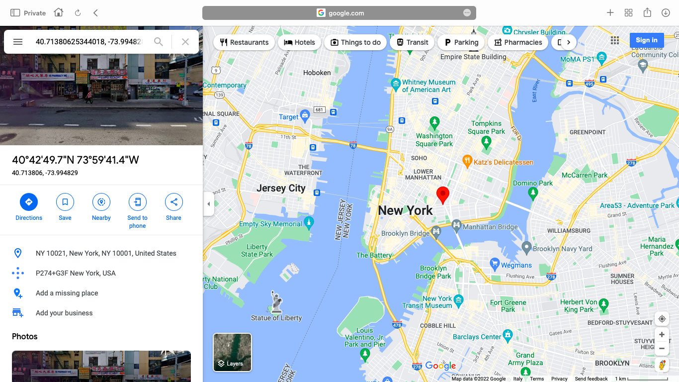
Geographical coordinates of New York in Google Map / Google
Third, ther are a few more rules for reading geographic coordinates
Another important difference between the three systems is that the DMS uses the letters to represent one of the four cardinal directions: N, S, E, and W (north, south, east, and west), but the DD and DMM usually do not. How, then, do we know which part of the earth we’re talking about? Note the minus (-) signs in front of the numbers with degrees.
The minus in latitude tells you that it is south (S), i.e. degrees with negative values, which are located BELOW the equator, i.e. below zero.
Similarly, a minus in longitude tells us that it is west (W), that is, degrees with negative values, which are located to the LEFT of the zero meridian, that is, below zero. It is like with time zones, which are also counted from Greenwich: +1 hour, +2 hours, and so on as one moves eastward. When it's evening in Japan, it's still morning in France, and it's the previous day in the United States.
So, northern latitudes and eastern longitudes are always positive. Southern latitudes and western longitudes are always negative.
For example, let's go back to the four-parts-of-the-world example:
- Top right part: Moscow is 55.7558° N (latitude), 37.6173° E (longitude) or 55.7558, 37.6173
- Bottom right part: Sydney is 33.8688° S (latitude), 151.2093° E (longitude) or −33.8688, 151.2093
- Bottom left part: Sao Paulo is 23.5558° S (latitude), 46.6396° W (longitude), or −23.5558, −46.6396.
- Top left part: San Francisco is 37.7749° N (latitude), 122.4194° W (longitude) or 37.7749, −122.4194
But in some sources, such as Google search results or in the Windy.app mobile application, you do not need to remember the minus. In the decimal degrees (DD) format, you can also sometimes see letters for the side of the world before or after degrees, for example, N 41.40338, E 2.17403 or 41.40338 N, 2.17403 E. This is done for a quicker understanding of coordinates.
Also, pay special attention to the punctuation in all three formats, and especially in DD coordinates — it is very important. Degrees are and should be followed by a dot, not a comma. If you use a mobile app on your smartphone, for example, to search for a place, it probably won’t find it:
- Correct: 41.40338, 2.17403
- Incorrect: 41,40338, 2,17403
In DD and DMM formats, latitude and longitude are also separated by commas, while in DMS format there is a space between them, but there can also be a comma. There is also a space between the degrees and minutes in DMM format, along with the degree sign (°).
Finally, what to do if you see one format but you need another? You can easily convert one to the other. This can be done with any online converter, which can be found on the Internet, although there is also a manual conversion for those who had an A in algebra in school.
Where to get longitude and latitude?
In the Windy.app, which contains a database of tens of thousands of spots for dozens of sports, you can find the exact geographic coordinates of these spots or any point of the world in different formats in several places and in different ways.
The easiest one is to simply click on the Weather Map at any location and get the coordinates in a pop-up window.
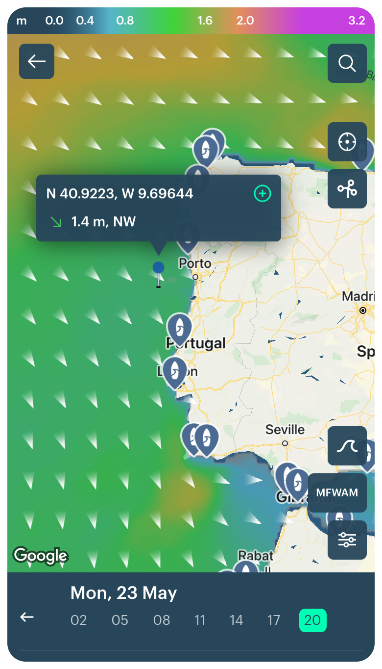
Geographic coordinates in the DD format on the Weather Map in the Windy.app for iOS
Or, it could be a particular spot, where you can see the DMS format. In the Windy.app, it is available for marinas as in the case of Marina de Cascais in Portugal.

Geographic coordinates in the DMS format on the Weather Map in the Windy.app for iOS
Learn how to find out geographic coordinates for other marked spots or the spots themselved using coordinates in a separate tip in the Support section of the site.
Text: Ivan Kuznetsov, an outdoor journalist, editor and writer from the Dolomites, Italy, and Karelia, Finland, with 10 years of professional experience. His favorite sports are hiking, cycling and sauna. Read his other articles
Cover photo: Blair Fraser Onoebmehmcc / Unsplash
You will also find useful
Contour lines — a useful tool for better weather forecasting
How to read wind direction. Even if it sounds too simple
What is the Karman line and how it defines the edge of space
Latest News
Professional Weather App
Get a detailed online 10 day weather forecast, live worldwide wind map and local weather reports from the most accurate weather models.
Compare spot conditions, ask locals in the app chat, discover meteo lessons, and share your experience in our Windy.app Community.
Be sure with Windy.app.


