
What is the Karman line and how it defines the edge of space
In July 2021, Richard Branson and Jeff Bezos went to space. But the question about edge of space remains open even after their successful flights.
In this article, you will learn what the Karman line is, which says right the same thing. Considering recent events of the first two tourists sent to space by the private companies, this line may be changed, which could lead to reviewing a few historical facts of who has been beyond the Earth and who has not.
What is the Karman line and the edge of space?
In the 20th century, there was a Hungarian physicist Theodore von Kármán. He was into aeronautics and astronautics and spent his whole life working in these fields.
He was born in Budapest, however, he did most of his research in the USA. His contribution in the fields of aeronautics and astronautics is immeasurable because of his theories of non-elastic buckling, stability of laminar flow, and many others.
Kármán also was the first person to calculate where the Earth’s atmosphere becomes too thin for airplanes to fly. In 1957, he set this boundary at 275,000 ft (83.82 km), or Von Karman line.
There are different layers of the atmosphere that are distinguished based on their temperature, chemical composition, movement, and density. These layers are the troposphere, the stratosphere, the mesosphere, the thermosphere, and the exosphere.
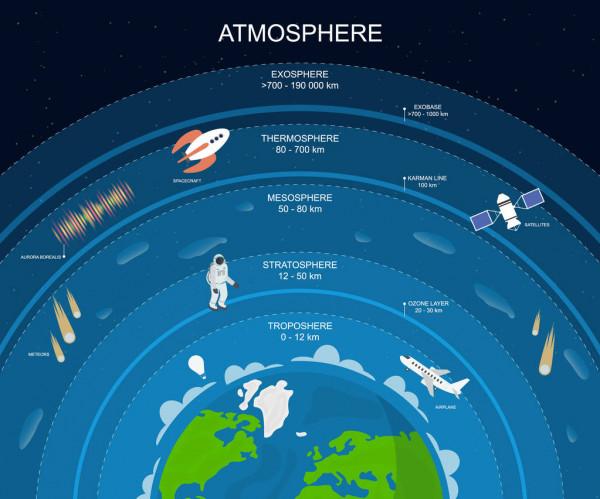
Layers of atmosphere. Photo: Depositphotos.com
- The troposphere is the lowest layer, the one where we live; It starts at the Earth’s surface and extends 8 to 14.5 kilometers high (5 to 9 miles). Planes, balloons, drones-all fly here.
- The next layer is the stratosphere, which extends to about 50 km (31 miles). The ozone layer is there. This is the highest layer that can be accessed by jet-powered aircraft.
- After it goes the mesosphere with its highest point at about 85 km (53 miles). Meteors burn up in this layer and it’s accessed by sounding rockets and rocket-powered aircraft.
- The thermosphere starts just above the mesosphere and extends to 600 kilometers (372 miles) high. Aurora and satellites are in this layer. The International Space Station is also there, between 350 and 420 km (220 and 260 mi).
- The last layer is the exosphere with only a few oxygen and hydrogen atoms. There you can find artificial satellites.
The Karman line (Kármán line) or can be found between the mesosphere and the thermosphere. However, even there the atmosphere still exists and it lasts for many kilometers and miles. So why is this interpreted as the edge of space?
To tell you the truth, this is only an attempt to define the space boundary that is used by the Fédération Aaéronautique Internationale (FAI) based in Lausanne, Switzerland, an international record-keeping body for aeronautics. There are many other space edge theories: from the concept of free molecular flow to the NASA limitation at 80 kilometers or 50 miles.
How do we define the boundary of space and what can it be important for?
However, the official space boundary by the FAI is set at 100 km while Kármán set it at 83,82 km. How could this happen?
According to Thomas Gangale, an expert on space law and executive director of OPS-Alaska, Kármán didn’t try to define the edge of space, he was trying to find an altitude where planes can fly and still generate lift. Gangale and another spaceflight expert Jonathan McDowell suppose that the FAI changed that value because people simply started rounding up to a nice easy-to-remember number. “Around 1960, the FAI decided to set the limit at 100 kilometers, just for the purpose of record-setting flights — that any flight above that would be considered to be a spaceflight.”
So, there are different definitions of the space edge:
- 52 miles or 83.82 km — by Karman
- 80 kilometers or 50 miles — by NASA
- 100 km or 62 miles — by FAI

Edge of space. Photo: NASA
So what do we define the space boundary for? This parameter is very important not only for the astronauts and pilots but for some people from other fields. Here are some examples:
Meteorology
Many meteorological organizations, for example, the NOAA, set their meteorological satellites in the atmosphere. There the satellites detect the development and movement of storm systems and clouds that helps to predict the weather. Sometimes they are also used to detect other dangerous phenomena like fires and sand storms.
With the help of these weather satellites, scientists collect precious data. For example, they are used to monitor the volcanic ash cloud from Mount St. Helens and activity from other volcanoes such as Mount Etna.
There are two types of satellites around the Earth: polar-orbiting (covering the entire Earth asynchronously), or geostationary (hovering over the same spot on the equator). For each of them, the scientists calculate the height so that the satellites provide accurate data and don’t fly away from the Earth or burn up in the atmosphere, and that’s where they use the Karman line.
Satellites for global Internet from Elon Musk and others
The CEO of Tesla announced in January 2015 that he was going to place around 4,000 satellites in low Earth orbit to provide low-cost internet to remote locations. They have to use the Kármán line to define the right place to set their satellites so they could fly around the planet and don’t crush or burn in the atmosphere.
However, he’s not the only one who wants to build a global satellite-internet network. There’s a whole competition among the biggest companies in the world. For example, the founder of Amazon Jeff Bezos revealed in 2018 “Project Kuiper”, which aims to blast 3,236 satellites to 630 kilometers into orbit. 50% of them should be there by July 30, 2026.
The other participants of this race are Google, ViaSat, Hughes Net, the UK’s OneWeb, Eutelsat, and Canada’s Telesat.
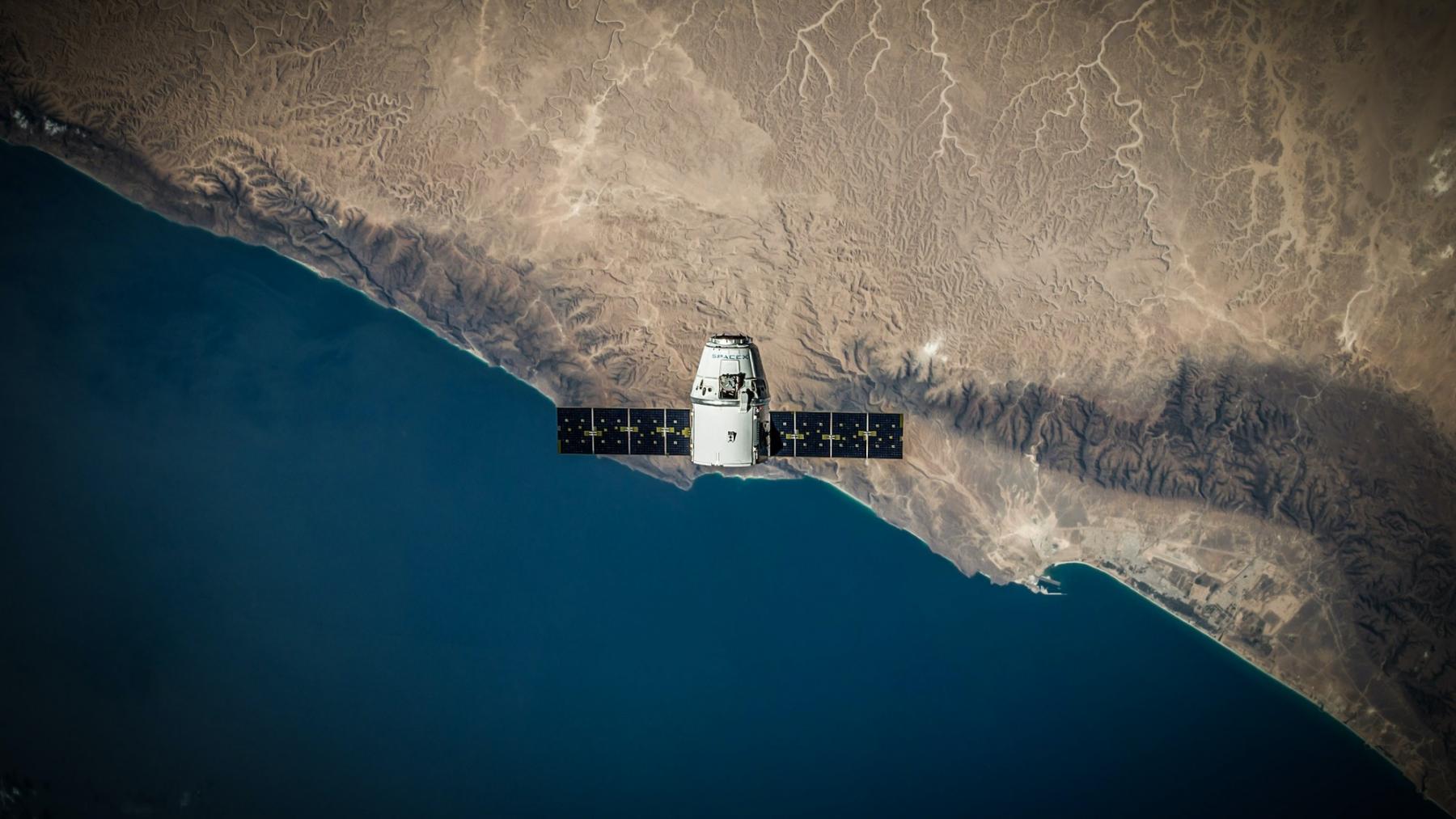
Satelite. Photo: Spacex / Unsplash
Air forces and boundaries of countries
It’s necessary to define air borders of countries because you can’t lawfully cross them as you wish. However, space is free to use.
In the 1950s the concept of “Freedom of Space” appeared, which means that outside the national airspace, nations are allowed to conduct peaceful space operations without concern for international borders. This concept exists today and many countries use it to make scientific research in space without any political restrictions.
So, in theory, you can get to another country through space or just fly above it without breaking the law. That’s why it’s essential to define space borders to prevent such actions.
Space tourism
There is another sphere where the space definition is important and it’s space tourism. Defining space could help companies to set the flights at direct heights and allow certain people to fly.
Two recent flights from Richard Branson and Jeff Bezos show how important it is to find this definition.
- The first one flew to the height of around 86 km (53 miles) on Virgin Galactic’s SpaceShipTwo (VSS Unity) on July 11, 2021.
- The second one with Bezos and other people on board of the “New Shepard” spaceship reached 107 km (66.4 mi )on July 20, 2021.
Virgin Galactic argues that it went to space; however, many scientists disagree with this. They use the definition of the Karman line by the FAI, so it has to be at 100 km, which Unity didn’t reach.
On the other hand, Virgin Galactic is appealing to NASA and the original Karman line height where it is below 86 km. This disagreement is yet to be solved.
The fact that Jeff Bezos was in space is beyond criticism. However, now he has to prove that he’s an astronaut in order to get the astronaut wings and be recognized as one.

SpaceX rocket going to the boundary of space and beyong. Photo: Spacex / Unsplash
Extreme sports and outdoor activities
In some sports, it’s necessary to know where the atmosphere ends. For example, skydivers have to know where space starts in order to achieve spots from which it can be less dangerous to jump. If they know where space starts, they can set records and experience amazing feelings when they skydive.
One of the most impressive jumps called "Skydive from the edge of space" was made by Alan Eustace in 2014. He made a parachute jump from 135,890 feet (41,419 meters). He was wearing some kind of spacesuit because of the rarefied air up there. This suit could also save him from burning during the fast falling.
Falling down, he broke the sound barrier and set some skydiving records. This is considered one of the greatest skydiving jumps the world has ever seen.
Where to find information about the atmosphere and space in Windy.app?
Weather is the current state of the atmosphere, which means that all weather phenomena on earth take place in it. Therefore, almost everything you see in the app is about the atmosphere. It also has some data about space.
Here are some examples of weather parameters and where to find them:
Atmospheric pressure
Atmospheric pressure is the pressure of the air on the Earth. The ligher you are, the less air there is above you, so the pressure decreases. Thanks to all this, you can use atmospheric pressure to predict the weather the following way: High pressure signals sunny and calm weather, and low pressure allows cloud growth and more precipitation. The faster the pressure drops, the sooner the weather gets worse.
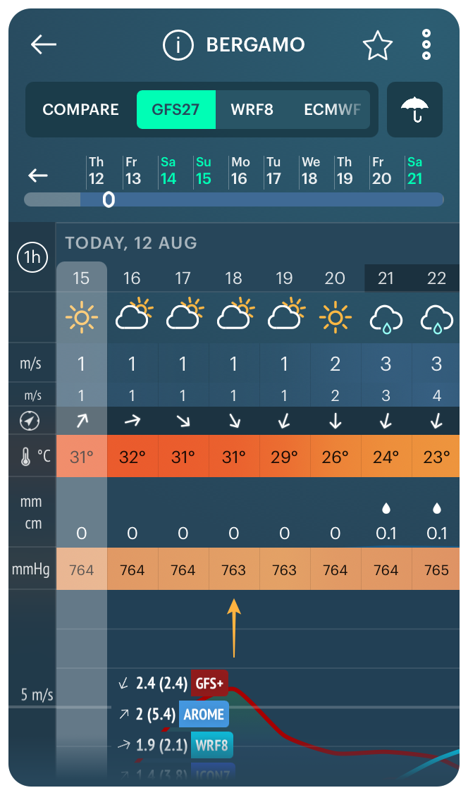
Atmospheric pressure for Bergamo, Italy, in Windy.app for iOS
How to get atmospheric pressure in Windy.app
1. Open your favorite spot or the nearest one to your current location.
2. Choose Lite Weather Profile.
3. Check the pressure in the weather parameters table.
Weather Fronts
The atmosphere consists of air masses that are constantly moving. A weather front is the boundary of huge air masses. If cold air moves into warm air territory, it is a cold front; if warm air moves into cold air territory, it is a warm front. The cold fronts bring colder air and good visibility. With a warm front, the sky is usually completely overcast. Warm fronts pass with rains, sometimes with thunderstorms.

Weather Fronts for North America in the Windy.app for iOS
How to get weather fronts in Windy.app
1. Open the Weather Map from the Home screen of the app.
2. Choose Weather Fronts and Isobars feature.
3. Check the front on the app: red, blue, orange, and purple lines.
Solunar forecast
You can use the power of the moon to catch more fish. Because, in theory, animal activity depends on the phase of the moon. Using it wisely can help you catch a bigger fish. Solunar forecast helps you to choose the best time to catch more fish. The chart is also very useful: it is a percentage of biting to make the situation even clearer.
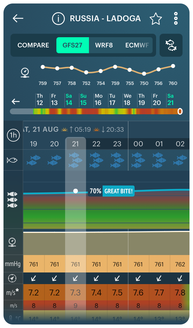
Solunar forecast for Ladoga Lake fishing spot in the Windy.app for iOS
How to get the solunar forecast in Windy.app
1. Open your favorite spot or the nearest one to your current location.
2. Choose Fish and Fish Pro Weather Profile.
3. Check the solunar forecast and chart in the weather parameters table.
Text: Ilia Ponomarev, a linguist and translator from Dzerzhinsk, Nizhny Novgorod Oblast, Russia. His favorite sports are cycling and hiking. Ivan Kuznetsov contributed to this article
Cover photo: NASA / Unsplash
You will also find useful
What Aurora is and where it comes from
Where and when to better look at the stars
What is Halo — a circle around the Sun
Latest News
Professional Weather App
Get a detailed online 10 day weather forecast, live worldwide wind map and local weather reports from the most accurate weather models.
Compare spot conditions, ask locals in the app chat, discover meteo lessons, and share your experience in our Windy.app Community.
Be sure with Windy.app.


