Okta — must-know measurement unit of clouds amount
Okta is a measurement unit of clouds amount. You are unlikely to see this symbol in a modern weather map in a mobile application or on a site like this. However, given that you may still encounter it, for example, in forecasts for aviation, let's understand what an okta is and how to read it. In general, if you are interested in meteorology, knowing oktas is a must.
What is the okta measurement unit?
Okta is the unit of measurement of clouds, or rather a cloud amount or cover, as it is also called, which is a part of the sky covered by clouds in relation to an observer (weather station) at a certain point on land or at sea. In other words, cloud cover is the amount of clouds in the sky or the degree of cloud cover. This is one of the main weather elements.
Today in meteorology it is expressed mainly as a percentage. For example, if the sky is 100% covered by clouds, it is a totally cloudy day. If the cloud cover is 25% — the day is more clear than cloudy. The cloud cover of 0% means it is a clear day with no visible clouds at all. So it is also called the percentage of the cloud coverage of the sky.
But in the past to indicate the cloud coverage on the paper weather maps people used a special sign called “okta,” which shows just the same. Or almost the same.
How to read okta symbols?
An okta is a circle divided into eight parts, each part representing how many eighths of the sky is covered by clouds. Therefore, the okta is also called “eighths”. Abbreviations are also used to refer to the oktas. So, here’s what each okta looks like and exactly what it means according to the World Meteorological Organization:
- 0 oktas (SKC): Sky clear — Fine
- 1 okta (FEW, Few clouds): 1/8 of the sky covered or less, but not zero — Fine
- 2 oktas (FEW): 2/8 of the sky covered — Fine
- 3 oktas (SCT, Scattered clouds): 3/8 of the sky covered — Partly Cloudy
- 4 oktas (SCT): 4/8 of the sky covered — Partly Cloudy
- 5 oktas (BKN, Broken clouds): 5/8 of the sky covered — Partly Cloudy
- 6 oktas (BKN): 6/8 of the sky covered — Cloudy
- 7 oktas (BKN): 7/8 of sky covered or more, but not 8/8 — Cloudy
- 8 oktas (OVC): 8/8 of sky completely covered, no breaks — Overcast
In addition, there are also two more oktas. An okta 9 is used when the sky itself is not visible (obscured sky). This may be for example due to low-lying fog or heavy snowfall and other similar phenomena. An okta 10, or rather no okta, is a special sign — two horizontal lines in a circle. It is used when no measurements were taken at all.
Oktas values are usually presented in tables like this one:

Oktas cloud cover scale. Valerya Milovanova / Windy.app
It’s important to know that the oktas estimate cloudiness only in terms of sky area. They do not take cloud type or height into account, meaning these are clouds of any type and at any height, which limits the use of oktas to estimate cloud reflectivity, another clouds measurement parameter.
Here’s an example of the use of oktas on a weather map — they’re very small here. Interestingly, they are partly labeled along with other weather symbols, in particular, a wind barb usually extends from the okta to indicate wind direction and speed, and there may be numbers around the oktas indicating air temperature, precipitation, and other weather data.
Image source: Amaris Dalton / Researchgate.net
Where to get clouds forecast?
The forecast of clouds is one of the main in the Windy.app, along with the wind speed and direction, air and water temperatures, precipitation and other forecasts. Of all the above types of cloud measurements, you can find two of them in the app: cloud base and cloud cover (clouds).
Cloud base
You can find the cloud base parameter in a special weather profile for all wind sports in the air called the same — "Air". To do so:
1. Open your favorite or nearest spot from the Home Screen of the app or from the Weather Map. Let's take the Monte Avena paragliding spot located in the Dolomites mountains in Veneto region in Italy, as an example. It is a fairly flat mountain that is easy to jump from. The height of this mountain is 1,450 m (4,770 ft) above sea level.
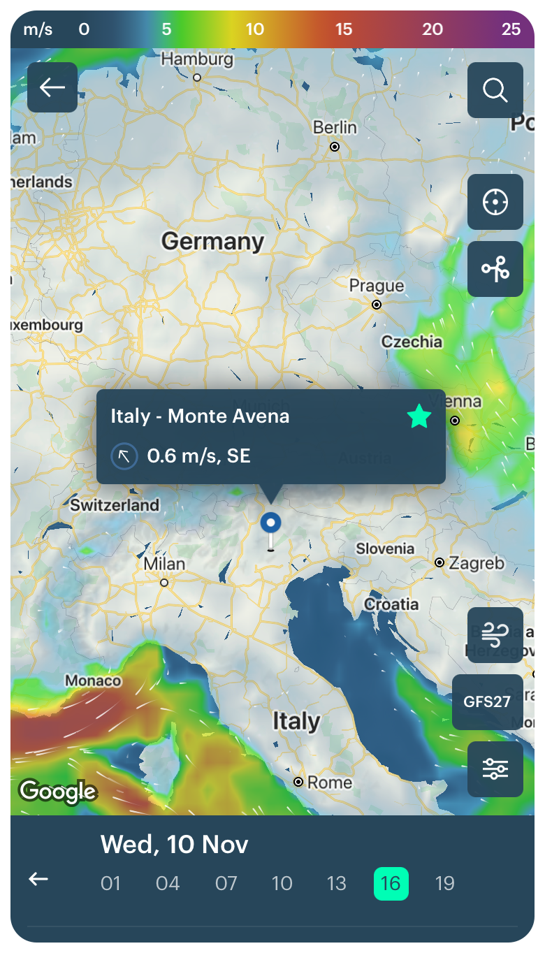
Monte Avena paragliding spot in the Dolomites, Italy, in the Windy.app for iOS
2. Select the Air Weather Profile using the icon to the right of the weather models:
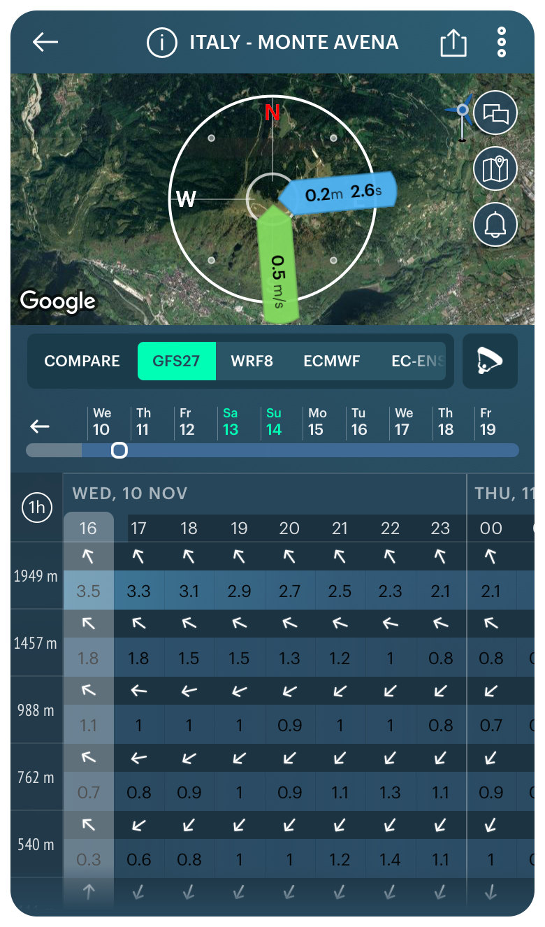
Air Weather Profile in the Windy.app for iOS
3. Get a cloud base forecast for today as well as for the next 10 days. You can also change the forecast step from 1 to 3 hours.
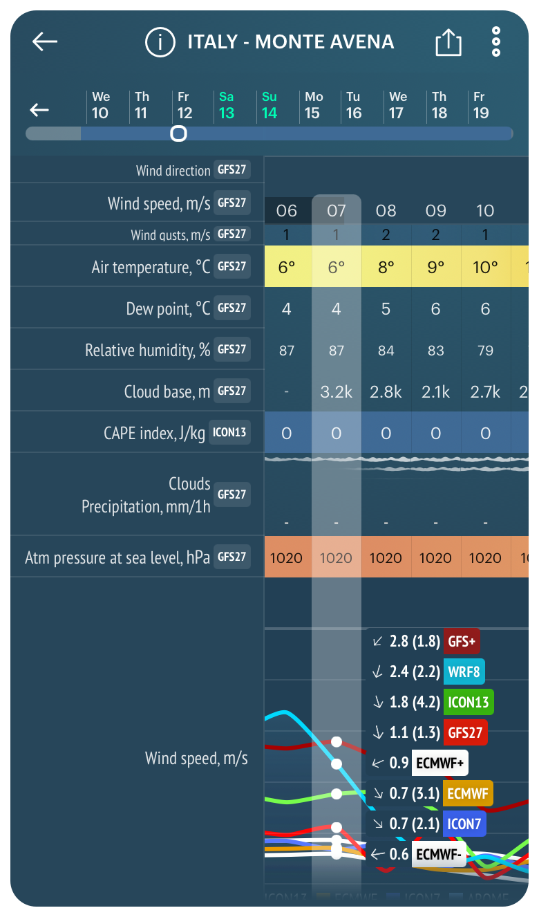
On the date of the writing of this particular text, in the forecast we see that the maximum cloud base on Monte Avena in the next three days will be 3,200 m (10,498 ft) on Friday, November 12 at 7 am, and the minimum cloud base will be 1,100 m (3,608 ft) on Saturday, November 12 at 08 am.
Maximum cloud base for Monte Avena in the Dolomites, Italy, in the Windy.app for iOS
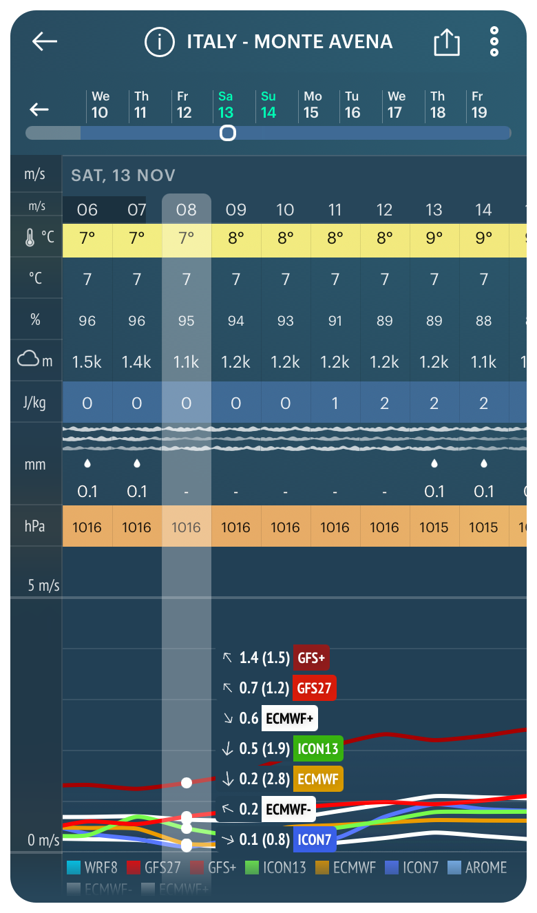
Minimum cloud base for Monte Avena in the Dolomites, Italy, in the Windy.app for iOS
This means that at the minimum cloud base the clouds will cover the highest point of the mountain, so jumping on that day and at that time may be problematic.
Looking at the forecast for many days, you can also calculate the average base of clouds for the spot by yourself. This is somewhere around 1500–2000 m (4,921–6,561 ft).
Clouds (cloud cover)
The cloud cover is available in the same Air Weather Profile, as well as in all other 10 weather profiles according to all 10 weather models in the app under the general name “Clouds”.
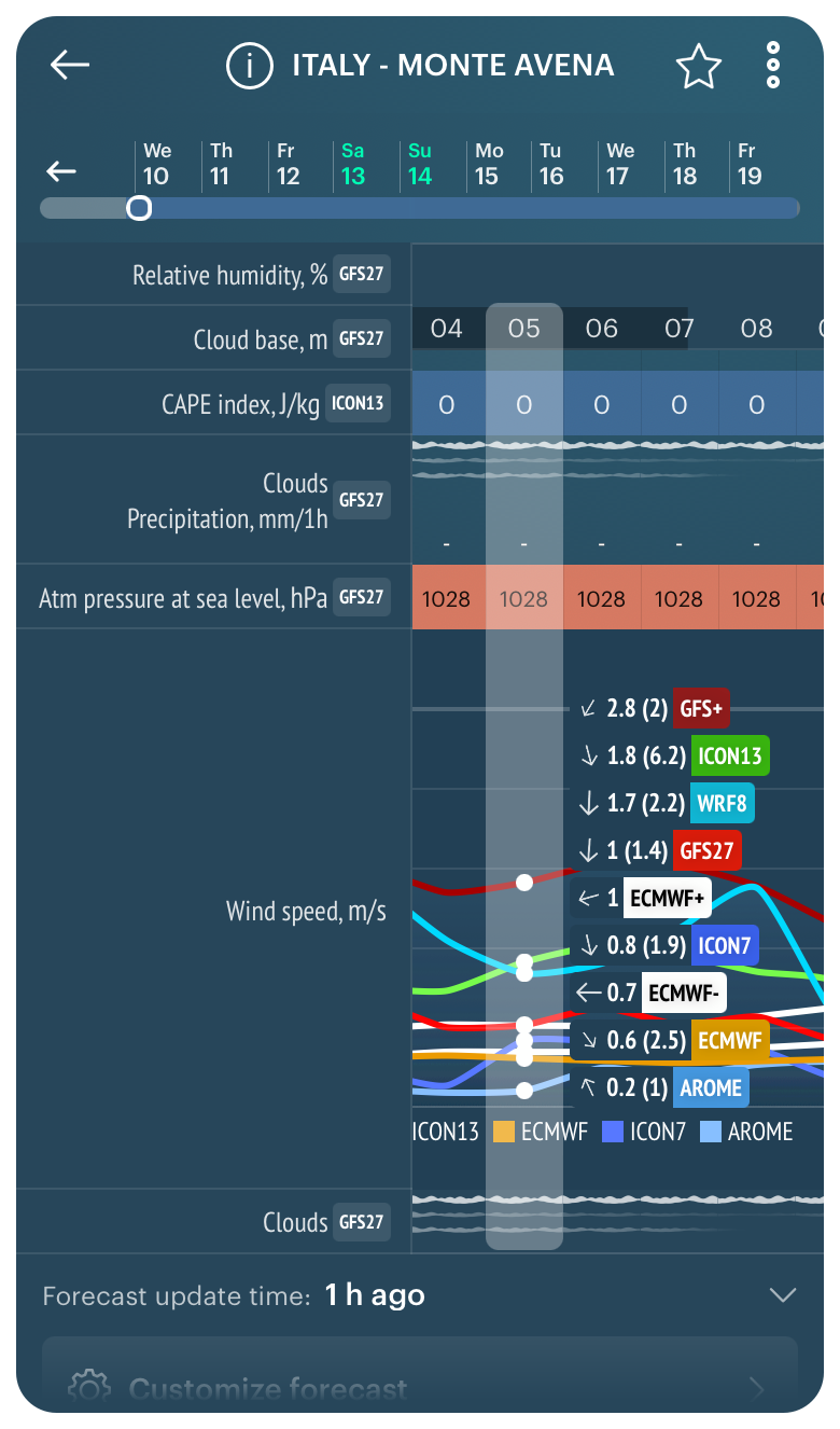
Cloud cover in the Windy.app for iOS
In contrast to the common expression of the parameter in percentages or oktas on weather maps, in the Windy.app you see a graph with layers of clouds. It can be one layer, two layers, or three layers — but no more, or no layers at all.
- One layer means few clouds — up to 50% cloud coverage of the sky
- Two layers — middle amount of clouds — about 50% cloud coverage
- Three layers — lots of clouds — more than 50% cloud coverage
- No layers — no clouds — 0% or so of the sky is covered by clouds
The number of layers also literally shows how many layers of clouds are in the sky in a system of three main layers, which refers to the clouds layers parameter.
Pay attention also to the color and thickness of each layer itself, I mean, the line. The darker it is and the thicker it is, the more clouds are in the sky and the denser the layer. And vice versa: the lighter and thicker the line, the thinner the layer, and the fewer clouds in the sky.
In any case, before you get in the air to do your favorite wind sport, check the forecast by different models, as well as just visually on the day of your trip.
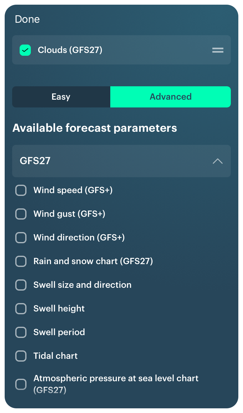
Last but not least, you can select the Clouds forecast as a separate item and add it to your Custom Weather Profile using the Customization feature. To do this, go to the Weather Profiles Screen and select it in one of the models. Then check the forecast.
Adding cloud cover on the Weather Profile Screen in the Windy.app for iOS
Learn more about clouds in the Windy.app Meteorological Textbook.
Text: Ivan Kuznetsov, an outdoor journalist, editor and writer from the Dolomites, Italy, and Karelia, Finland, with 10 years of professional experience. His favorite sports are cycling, hiking and sauna. Read his other articles
Cover photo: Lennart Heim / Unsplash
You will also find useful
Explore the different types of clouds
What is cloud base and how else do we measure clouds
Aerological diagram — a useful tool for weather forecasting at different heights
Latest News
Professional Weather App
Get a detailed online 10 day weather forecast, live worldwide wind map and local weather reports from the most accurate weather models.
Compare spot conditions, ask locals in the app chat, discover meteo lessons, and share your experience in our Windy.app Community.
Be sure with Windy.app.


