
How to get the most accurate weather forecast. Is it really possible?
The weather forecast could be a mess — unhappily familiar to anyone who uses weather apps and sites.
"Real weather outside differs from predicted one", "It spoiled my long-expected and deserved outdoor activity", "I want another mobile weather application". You end with five weather apps on your device or weather sites in your browser's bookmarks looking through all of them trying to get a clue and find a consensus. If only it could help to get the most accurate weather forecast.
It would be much easier to know exactly if it’s going to rain tomorrow and when or what the wind picture is in the area you’re looking at.
However, it's impossible to predict the weather with 100% sure. But it is possible to improve your "gut feeling" understanding what an accurate weather forecast is and how it works.

Ilya Drigo, professional meteorologist, developer, and researcher
What is weather forecast accuracy?
— The fact is that the initial data for calculating weather forecasts can never be absolutely accurate: weather stations work differently, weather satellites have some errors, and the like. So, in general, we just can’t measure the weather absolutely accurately.
There is a thing called the Butterfly Effect, which is usually associated with the American mathematician and meteorologist Edward Norton Lorenz. Because we don’t have very accurate initial data from these and many other weather instruments and because the atmosphere is terribly chaotic, we get a huge variation in how the weather model can predict the weather. This is what the idea of ensemble forecasting (right next), in particular, is based on.
Imagine a giant tub of cold water: you pour a glass of boiling water in there. What will happen? Some waves will start to move around in it, the water of different temperatures will start to mix, so there will be some processes for sure. Now imagine that you need to predict where dust at one end of the tub will move, and the tub is big. And you have to predict it a day in advance, more — three, five, ten days... That’s about what meteorologists do when they make a weather forecast.
Again, the weather system is very chaotic, and so it is impossible to predict absolutely precisely, so the “Butterfly Effect” occurs, the essence of which is that even a small change, in the beginning, gives a huge change later. The same with the weather forecast accuracy.
Because of peculiarities of calculation and numerical scheme of weather model, the relief of the model is always averaged. The bigger is the square of the weather model grid for which the weather forecast is calculated, the lower is the resolution and the smoother is the forecast — that is less accurate.
For example, for some global weather models like GFS or ECMWF, a small strait in the ocean or sea may not even exist, simply because the model grid does not allow to see such “small” details in the relief. Because of this, errors in weather forecasting accordingly arise. That is, the model averages the data over space.
But let us not forget that space is not only a horizontal plane, but also a vertical one. Didn't you know that wind is predicted for 10 meters height in any weather service? It's related to the way the wind is observed: weather stations measure the wind on this particular altitude. So adjust the predicted wind to your activity: height of your mast, your personal height, the level your kite flies, and so on. In general, the wind rises with height (but not always).
The model also averages in time because the model makes a forecast usually for an hour or three hours ahead, what is called the "weather forecast step". In an hour, the atmosphere can change completely.
For example, the weather model will say that in some particular hour you will have a wind speed of 10 m/s, but you will have 50 minutes of calm, and in the last 10 minutes a squall will come, and this 10 m/s that you saw in the forecast will not suit you very well, right? But to give out so every minute forecast — it’s very difficult, almost impossible to calculate for weather forecast models.
Therefore, both meteorologists and consumers of weather forecasts in fact have to put up with the fact that there is averaging of the forecast. In reality, of course, it is not as literal and simple as I told you: if there is a squall, we will see it as wind gusts (a brief increase of the moving air velocity, usually for no more than 20–30 seconds) in the forecast, but we need to understand that the model is always averaging.
By the way, if it's gusty outside, it feels like the wind is stronger than predicted. So always also look at gusts. Numerical forecasts also mess with light winds in general due to the same models' calculation process. Be cautious if you see wind less than 5 knots.

Chris Lawton / Unsplash
How accurate are weather forecasts for 3 days, 10 days, and more?
Forecast accuracy also depends on its duration. It's a little simpler here than in the previous part of the article. The main thing to know about the relationship between time and forecast accuracy is that over time, the accuracy keeps dropping. Unfortunately. The farther into the future we look, the worse our forecast is.
Moreover, forecasts depends on weather elements themselves. But weather elements do not exist out of context. Of course they are connected to time and space in different ways. So different weather elements or weather parameters have different accuracy. Let's deal with the three main ones: air temperature, precipitation, and wind.
- The air temperature is the easiest to predict, so we predict it pretty well. For today its accuracy is about 95–96% but every day it goes down by about 3%. The accuracy in a week's forecast is about 70% in general.
- Precipitation is the hardest weather element to predict. I think you have seen it yourself many times in the forecast: no rain was expected, and suddenly it rains. Or vice versa. Meteorological science is developing in this direction: for example, weather radars help us a lot, but it's still a very complicated thing.
- The wind is somewhere in between. We predict it is a little worse than the temperature but better than the precipitation. Every day we have a drop of about 4–6%, that's how the researchers estimate the accuracy of the wind forecast, i.e., pretty good overall.
Accuracy also depends on the types of some weather elements. For example, speaking about types of winds, especially the local ones like breezes, they are not fully considered by the global weather models. But these are exceptional regional weather forecast models like AROME for Europe and HRRR for the continental US, which are quite accurate.
Individual types of precipitation — and there are at least a few dozen of them besides rain and snow (hail, snowstorms, etc.) — are also easier and harder to predict.
As a result, taking into account the accuracy of the forecast for individual elements, we can be confident in the general accuracy using the following scale:
- For about three days, we give a good reliable forecast. I can say that this is a certain standard in weather forecasting that you should always be guided by.
- A week and 10 days are trustworthy, but it's better to double-check it and to use some extra other tools, about which I will tell right next.
- Two weeks is the physical limit of predictability for medium-term forecasts. This is due to the lifetime of a variety of weather formations, such as tropical cyclones, for example.
- The monthly forecast can be checked for general purposes, and should probably not be trusted too much.
If you need the weather for a month or more, it is better to look at the history of the weather to see how it has changed over the years in a particular place to catch the pattern yourself.
Weather patterns, or averages, are climate — another thing. And here the situation is reversed, or rather, different. In general, we can predict the climate more or less, not badly, 2–3 years ahead, and in general terms a week ahead. But anything in the middle is a sore point for us because of the uncertainty of the weather.

Arek Adeoye / Unsplash
Where to get the most accurate weather forecast?
Because weather models work a bit differently and small changes in the initial data can make big changes in what happens next (Butterfly Effect), we at Windy.app have come up with a few features and tools, which will help you to get accurate information about what's going on with the weather. Use one of them, or better yet, all three for an even more accurate forecast.
First way. Compare weather forecasts
In the Windy.app we can take all the models we have for the spot and compare them. To do this, we use a special Compare Mode feature where you can compare four important weather parameters: wind speed, wind gusts, temperature, and atmospheric pressure from the different models.
In other words, we can see how clear the weather situation is for the particular model. If all the models go together, i.e. if the lines on the graph are close to each other and if all the models have approximately the same values (numbers), this means that the general weather situation is clear to the models and the forecast as a whole can be trusted. If the models diverge, it means the weather situation is unstable, it means each model reads it a little differently. And the more they diverge, the worse it is.
We can also get information about maximum and minimum values and about the average value.
Comparing models is a good, but not ideal and not the only sure way to improve the accuracy of the forecast. It is not always suitable because the models are still (and first) different and they work in different ways.
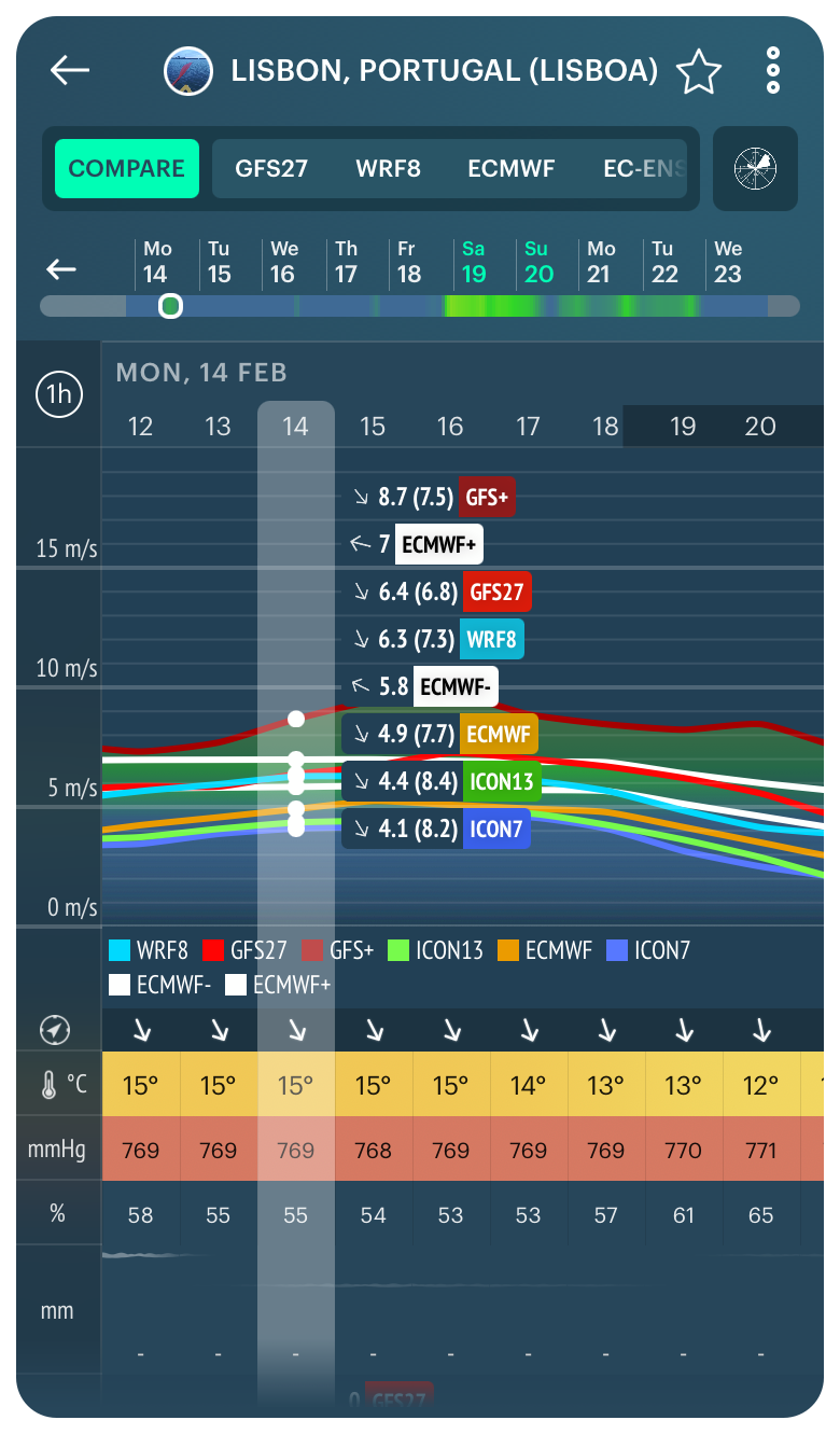
Compare mode of the weather forecasts for Lisbon, Portugal, in the Windy.app for iOS
Second way. Use Ensemble weather model
Let’s do the opposite: let’s take the same model and see how differently it behaves in unstable weather conditions.
An ensemble model is when we change values of weather elements slightly — for example, instead of the original 3 m/s for wind, we write 3.4 m/s — and make the forecast again. And then, we do it again and again — dozens of times — with the same model, but with slightly changed parameters for wind, precipitation, temperature, etc.
Both GFS and ECMWF and some other models do this kind of thing. GFS is run 20 times in particular. In the Windy.app, we use ensembles on ECMWF, which run 50 times.
The result is about the same as we see in the Compare Model: the maximum they predicted; the minimum; the control value (the value from the unchanged initial data); and how the regular ECMWF model behaves.
Here we can see how far apart these models are at all. The greater the difference, the less we can trust the forecast, and the more carefully we should look at this weather situation before making decisions. For example, in the case of yachting, what sails to take, when to go to the sea, and so on.
So ensemble models are a very useful thing. I encourage the use of them by all means.
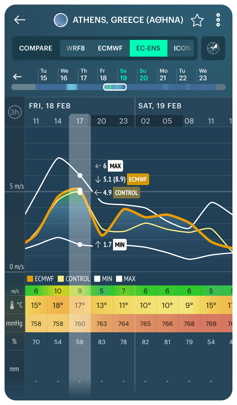
Ensemble model for Athens, Greece, in the Windy.app for iOS
Third way. Check weather history based on reanalyses
This is a very handy tool, which is also worth using for weather forecasting. While it is clear what weather history is: we take weather reports and put them together, let’s talk about reanalysis in more detail.
The name says that we have a history of weather and its analysis which was received due to the collected data from weather stations, satellites and so on. That is, we collect all the data that we have at a certain point in time. But we still do not have all the data because, for example, weather satellites do not cover the entire Earth at once, so there is a delay in getting the data. But when a few months or a year passes, the data come to us — we have a huge amount of data. Reanalyses combine this data, that is, it makes a procedure of assimilation of new data. It kind of reconstructs the weather puzzle of all the data and weather elements.
Okay, maybe I’m not being entirely accurate. Anyway, in fact, the reanalysis looks exactly the same as the weather history, it’s just put together a little differently.
You can find weather history in the Windy.app as well. Using it, you can see, for example, the wind roses for each day for the last 10 years (2021–2012).
I also highly recommend using this tool to improve the quality of the forecast, because this way you can learn which weather conditions are prevailing in a particular place and understand which winds are blowing here in July and so on.
It is useful to check the weather history as well as the weather forecast before you go to any spot.
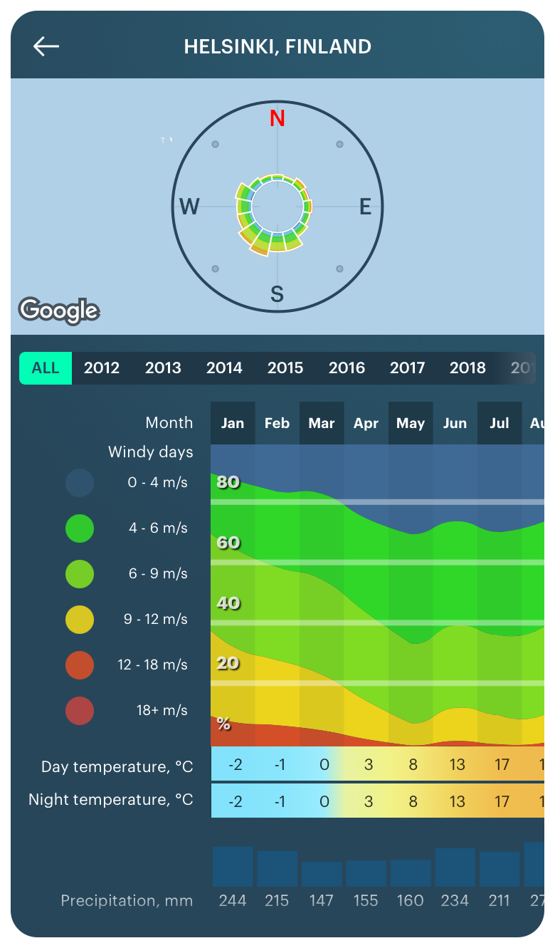
Weather history for Helsinki, Finland, in the Windy.app for iOS
Text: Ilya Drigo, pro meteorologist, developer, and researcher with a Bachelor’s degree in Oceanography, Meteorology and Hydrology from the Lomonosov Moscow State University (MSU), Windy.app’s ex-chief meteorologist. His favorite sports are hiking and sailing.
Cover photo: Jarrett Fifield / Unsplash
You will also find useful
How to read a weather map like an expert
What do weather symbols mean on your favorite app's screen
Contour lines — a useful tool for better weather forecasting
Three situations when you may need the offline weather forecast
What are wind alerts and how to use them
Latest News
Professional Weather App
Get a detailed online 10 day weather forecast, live worldwide wind map and local weather reports from the most accurate weather models.
Compare spot conditions, ask locals in the app chat, discover meteo lessons, and share your experience in our Windy.app Community.
Be sure with Windy.app.


