What are weather satellites and how do they help us get weather data
Weather satellites are one of the several main weather instruments along with weather stations, radars, buoys and balloons. In this article, we will get into the details of what weather satellites exactly are and how they help us obtain different meteorological information. We will also list the main types of satellites and some of their working features.
Weather satellites definition
Weather satellites are satellites launched by man for the purpose of collecting weather data from space.
They contain a set of tools that allow you to learn basic weather parameters like air temperature, precipitation, and wind but also advanced ones about, for example, snow and ice cover of the Earth, large-scale fires or volcanic eruptions, and the like, which are better “seen” from space, as well as to record space weather phenomena such as geomagnetic storms.
Weather satellites together with data reception and processing stations located on the ground form the meteorological space systems of different countries.
The main types of weather satellites
There are two main types of satellites: geostationary and polar orbiting.
Geostationary weather satellites orbit the Earth at an altitude of 35,880 km (22,300 miles) above the equator. This orbit ensures that they remain stationary with respect to the rotating Earth and can therefore continuously record data or transmit images using visible light and infrared sensors, which are then used by weather services. This allows the satellites to take a picture of the Earth in the same location every 30 minutes. It is interesting and important to note that during severe and extreme weather such satellites can take images every 5 to 15 minutes for a smaller area.
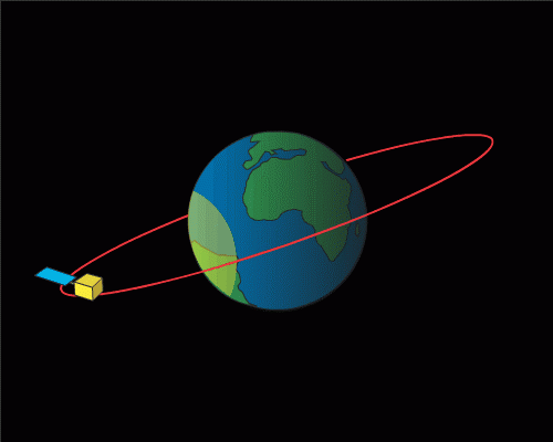
Geostationary weather satellite orbit in the yellow circle. Photo: NOAA
Polar orbiting weather satellites orbit the Earth at a much lower altitude of 850 km (530 miles) in a north-south (or vice versa) direction, passing over the North and South Poles. Unlike fixed satellites, they can observe any location on Earth: in particular, they see each location twice a day during the day and night. In general, these satellites are less useful for weather observation but, they are extremely valuable because they provide much better resolution than the first kind of satellite due to their proximity to the Earth, allowing us to get much more detailed images of storms, volcanoes, landslides, forest fires, and other natural phenomena on Earth simultaneously.

Polar orbiting weather satellite orbit in the yellow line. Photo: NOAA
There aren’t many satellites of either type — for example, no more than a dozen in the U.S., and a similar quantity elsewhere in the world.
Design and working features of weather satellites
Weather satellites look about the same as other satellites for cell phone and Internet distribution and other purposes.
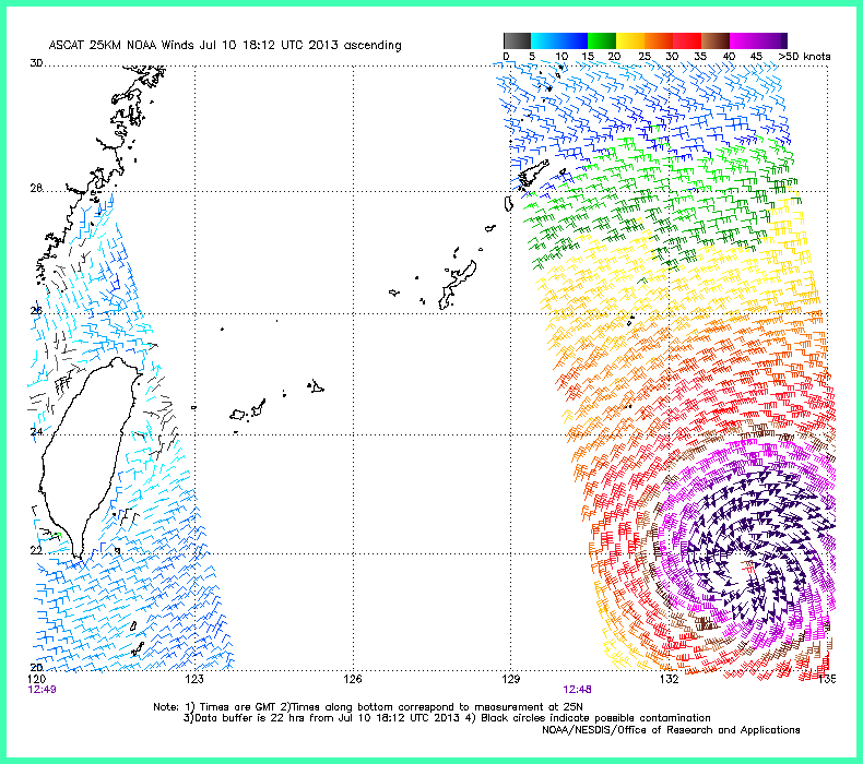
But these satellites have many operating features depending on the type, so let’s focus on weather elements that interest us the most — the wind. Wind speed and direction are measured on satellites with a device called a scatterometer or radar scatterometer.
In turn, the main feature of the scatterometer is that it measures wind only over water (the ocean makes up more than 70% of the Earth’s surface), thanks to radio or microwaves, which is similar to radar. It works exactly like this: by sending microwave pulses, the scatterometer receives signals reflected from the sea surface and by their intensity determines the degree of the wave caused by wind.
The scatterometer uses, among other things, a parabolic reflecting antenna to collect wind direction information. But we won't go into detail here to move on, because we have more specifics.
Another feature is that the satellite measures wind and other weather parameters in stripes. Typical stripe width range from 500 to 1,800 km, depending on the type of satellite. On weather maps, you can see that, for example, the Pacific Ocean is not completely covered because the satellite has not yet had time to fly over there, so when the satellite flies, it leaves a strip behind it. Why is this important for us? It is not a fact that a satellite will fly over the area you are interested in exactly when you need it to. Accordingly, if we want to get data from the satellite, we have to make sure that our area falls under his route.
A picture of category 4 typhoon Soulik made my weather satellite. Image: Wikipedia
Finally, we have two more features:
Satellite resolution averages between 12.5 and 50 km. This is not the highest resolution, but, as meteorologists say today, "thank goodness we have at least that". Because satellites are used to collect data in many areas of the world’s oceans. It’s essentially the only source of this kind of information.
The data from satellites is updated every 22 hours, depending, again, on the type of satellite.
Disadvantages of weather satellites
For all its unquestionable advantages for meteorology, satellites have three main disadvantages:
- Satellites perform rather poorly near ocean or sea shore. This applies more or less to all satellites, and scatterometers in particular.
- Data from the satellites get “contaminated” in stormy conditions when the wind often coincides with some precipitation, particularly rain.
- Radar scatterometers have a rather drastic drop inaccuracy. This is a tool you need to know how to use professionally.
Text: Ivan Kuznetsov, an outdoor journalist, editor and writer from the Dolomites, Italy, and Karelia, Finland, with 10 years of professional experience. His favorite sports are hiking, cycling and sauna. Read his other articles. Ilya Drigo contributed to this article
Cover photo: NASA / Unsplash
You will also find useful
How do we measure weather. The complete guide to weather instruments
The collection of articles about weather forecasting
Latest News
Professional Weather App
Get a detailed online 10 day weather forecast, live worldwide wind map and local weather reports from the most accurate weather models.
Compare spot conditions, ask locals in the app chat, discover meteo lessons, and share your experience in our Windy.app Community.
Be sure with Windy.app.


